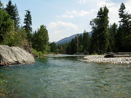
- Methow River
-
Methow River River The Methow River at MazamaCountry United States State Washington Region Okanogan County Tributaries - left Lost River, Chewuch River - right Early Winters Creek, Twisp River Cities Winthrop, Twisp, Pateros Source Cascade Range - location Methow Pass - elevation 5,677 ft (1,730 m) [1] - coordinates 48°35′9″N 120°44′44″W / 48.58583°N 120.74556°W [2] Mouth Columbia River - location Pateros - elevation 784 ft (239 m) [1] - coordinates 48°3′2″N 119°53′43″W / 48.05056°N 119.89528°W [2] Length 80 mi (129 km) [3] Basin 1,825 sq mi (4,727 km2) [4] Discharge mouth - average 1,522 cu ft/s (43.1 m3/s) [5] - max 27,200 cu ft/s (770.22 m3/s) - min 150 cu ft/s (4.25 m3/s) The Methow River (pronounced /ˈmɛt.haʊ/ met-how[6]) is a tributary of the Columbia River in northern Washington in the United States. The river's watershed is 1,890 square miles (4,900 km2), with a population of about 5,000 people. The Methow's watershed is characterized by relatively pristine habitats, with much of the river basin is located in national forests and wildernesses. Many tributaries drain the large Pasayten Wilderness. An earlier economy based on agriculture is giving way to one based on recreation and tourism.
The river was named after the Methow Native Americans (today part of the Confederated Tribes of the Colville Indian Reservation). The name "Methow" comes from the Okanagan placename /mətxʷú/, meaning "sunflower (seeds)".[7] The Native American name for the river was Buttlemuleemauch, meaning "salmon falls river".[8] In 1841 the Wilkes Expedition named the river "Barrier River". Alexander Ross said the native name was Buttle-mule-emauch. In 1811 David Thompson met the tribe living along the river and wrote their name as Smeetheowe. In 1853 George Gibbs called the river Methow or Barrier.[9]
Course
The Methow River, along with its tributaries the Twisp River, Cedar Creek, and Early Winters Creek, originates in a cluster of high mountains including Golden Horn, Tower Mountain, Cutthroat Peak, Snagtooth Ridge, Kangaroo Ridge, Early Winter Spires, and Liberty Bell Mountain. Several mountain passes are associated with the Methow River and its tributaries, such as Methow Pass and Twisp Pass. State Route 20 utilizes Washington Pass and Rainy Pass, also in the general areas of headwater streams.
The Pacific Crest Trail follows the uppermost reach of the Methow River, until the river turns east, flowing into the Methow Valley near Mazama. Along the way it collects the tributary streams of Robinson Creek and Lost River. In the Methow Valley, between Mazama and Winthrop, the Methow River is joined by Early Winters Creek, Cedar Creek, Goat Creek, and Wolf Creek. The Chewuch River joins at Winthrop. One of the Methow's larger tributaries, the Chewuch River and its many tributaries drain large parts of the Pasayten Wilderness to the north. One of its headwater streams, Cathedral Creek, reaches nearly to British Columbia, Canada.
The Methow Valley continues below Winthrop to Twisp, where the Methow River is joined by another important tributary, the Twisp River. Flowing from the west, the Twisp River drains the mountains south of Washington Pass as well as the eastern slopes of Sawtooth Ridge, a major mountain range with some of Washington state's highest peaks (such as Star Peak and Mt Bigelow).
Downriver from Twisp, the Methow River passes by the communities of Carlton and Methow, receiving several minor tributaries, before joining the Columbia River at Pateros. This part of the Columbia is the impoundment of Wells Dam, a lake known as Lake Pateros.
See also
- List of rivers of Washington
- Tributaries of the Columbia River
- Methow, Washington
References
- ^ a b Google Earth elevation for GNIS coordinates.
- ^ a b U.S. Geological Survey Geographic Names Information System: Methow River, USGS GNIS.
- ^ Methow River, The Columbia Gazetteer of North America. 2000.
- ^ "Wenatchee Subbasin Plan". Northwest Power and Conservation Council. http://www.nwcouncil.org/fw/subbasinplanning/wenatchee/plan/. Retrieved 30 July 2009.
- ^ http://pubs.usgs.gov/wdr/2005/wdr-wa-05-1/ Water Resources Data-Washington Water Year 2005
- ^ Webster's Geographical Dictionary.
- ^ Bright, William (2004). Native American placenames of the United States. University of Oklahoma Press. p. 280. ISBN 9780806135984. http://books.google.com/books?id=5XfxzCm1qa4C&pg=PA280. Retrieved 11 April 2011.
- ^ Phillips, James W. (1971). Washington State Place Names. University of Washington Press. ISBN 0-295-95158-3.
- ^ Meany, Edmond S. (1920). "Origin of Washington Geographic Names". The Washington Historical Quarterly (Washington University State Historical Society) XI: 204. http://books.google.com/?id=dbsUAAAAYAAJ. Retrieved 2009-06-11.
Categories:- Rivers of Washington (state)
- Tributaries of the Columbia River
- Landforms of Okanogan County, Washington
Wikimedia Foundation. 2010.

