- Chodov (Prague)
-
- There are several other places called Chodov in the Czech Republic
See also: Litochleby and Opatov (Prague)
Chodov (Czech pronunciation: [ˈxodof]) is a suburb of Prague in the Czech Republic. It lies in the south-east of the city, and became part of the Prague municipality in 1968. In terms of the Prague districts defined in 1960, it lay in administrative district 4, and its postal address is still Prague 4. However since 2001 it has been placed in the administrative district Prague 11; within that, it lies in the Prague 11 municipal district. It has a Metro station, on the C line. It is principally an area of large high-rise post-Second World War housing developments, but since the Velvet Revolution of 1989 there has been rapid development of commercial sites such as car dealerships; there are also some areas of detached housing. There are a number of hotels in the district, some of them large establishments catering to the congress and package holiday trade. Notable buildings include:
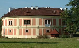
- the Chodovská vodní tvrz or Chodov fort, a round building with its origins in the 13th century (though heavily restored) which now serves as a cultural centre and includes a gallery and a small recital room.
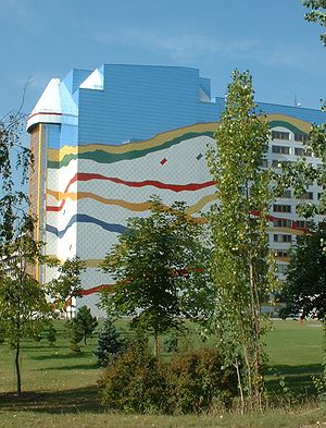
- the new location (opened on 1 January 1999) of the Prague City Archives, in a striking modern building
- The Chodov Shopping Center - one of the biggest shopping malls in Prague and in the whole Czech Republic with more than 210 stores; located above the Chodov metro station
External links
- Description of the new Archives building on the official Prague City Archives site
- Chodov fort official website
Districts and cadastral areas of Prague  Former names shown in italics
Administrative
districtsPrague 1 · 2 · 3 · 4 · 5 · 6 · 7 · 8 · 9 · 10 · 11 · 12 · 13 · 14 · 15 · 16 (Radotín) · 17 (Řepy) · 18 (Letňany) · 19 (Kbely) · 20 (Horní Počernice) · 21 (Újezd nad Lesy) · 22 (Uhříněves)
Municipal
districtsBěchovice · Benice · Březiněves · Čakovice · Ďáblice · Dolní Chabry · Dolní Měcholupy · Dolní Počernice · Dubeč · Klánovice · Koloděje · Kolovraty · Královice · Křeslice · Kunratice · Libuš · Lipence · Lochkov · Lysolaje · Nebušice · Nedvězí · Petrovice · Přední Kopanina · Řeporyje · Satalice · Slivenec · Suchdol · Šeberov · Štěrboholy · Troja · Újezd (u Průhonic) · Velká Chuchle · Vinoř · Zbraslav · Zličín
Cadastral areas Běchovice · Benice · Bohnice · Braník · Břevnov · Březiněves · Bubeneč · Čakovice · Černý Most · Chodov · Cholupice · Čimice · Ďáblice · Dejvice · Dolní Chabry · Dolní Měcholupy · Dolní Počernice · Dubeč · Háje · Hájek · Hloubětín · Hlubočepy · Hodkovičky · Holešovice · Holyně · Horní Měcholupy · Horní Počernice · Hostavice · Hostivař · Hradčany · Hrdlořezy · Jinonice · Josefov (Jewish Quarter) · Kamýk · Karlín · Klánovice · Kobylisy · Koloděje · Kolovraty · Komořany · Košíře · Královice · Krč · Křeslice · Kunratice · Kyje · Lahovice · Letňany · Lhotka · Libeň · Liboc · Libuš · Lipany · Lipence · Lochkov · Lysolaje · Malá Chuchle · Malá Strana ("Lesser Town") · Malešice · Michle · Miškovice · Modřany · Motol · Nebušice · Nedvězí · Nové Město ("New Town") · Nusle · Petrovice · Písnice · Pitkovice · Podolí · Přední Kopanina · Prosek · Radlice · Radotín · Řeporyje · Řepy · Ruzyně · Satalice · Sedlec · Slivenec · Smíchov · Sobín · Staré Město ("Old Town") · Štěrboholy · Stodůlky · Strašnice · Střešovice · Střížkov · Suchdol · Točná · Třebonice · Třeboradice · Troja · Uhříněves · Újezd nad Lesy · Újezd (u Průhonic) · Veleslavín · Velká Chuchle · Vinohrady · Vinoř · Vokovice · Vršovice · Vyšehrad · Vysočany · Záběhlice · Zadní Kopanina · Zbraslav · Žižkov · Zličín
Coordinates: 50°01′53″N 14°29′30″E / 50.03139°N 14.49167°E

This Prague location article is a stub. You can help Wikipedia by expanding it.


