March Township, Ontario

March Township, Ontario
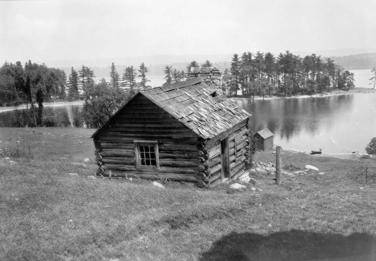
View of the Pinhey family homestead in March Township, built in 1825 with the Ottawa River in the background.

March Township is a geographic township and former municipality originally part of Carleton County in eastern Ontario, Canada. It is currently part of the City of Ottawa. It is located in the western part of the county, bordered to the northwest by Torbolton Township, to the southwest by Huntley Township, to the east by Nepean, to the south by Goulbourn Township and to the north by the Ottawa River.According to the Canada 2001 Census, the Township had a population of approximately 26,650.

Contents

History

The township took its name from the 4th Duke of Richmond, Charles Lennox's oldest son, the Earl of March.[1] The township was established in the 1820s. Early settlers in the area included Hamnett Kirkes Pinhey and Doctor Alexander James Christie. In 1978, most of the township became part of the new city of Kanata. The village of Dunrobin, Ontario was also located in the township. In 2001, this area was amalgamated into the new city of Ottawa.

Reeves

  • 1850 Hamnett Kirkes Pinhey
  • 1856 R.Y. Greene
  • 1864 W.H. Berry
  • 1868 R.Y. Greene
  • 1871 William Richardson
  • 1876 R.Y. Greene
  • 1897 n/a
  • 1907 S. Gilchrist
  • 1909 O. Riddell
  • 1910 S. Gilchrist
  • 1911 O. Riddell
  • 1912 Godfrey Armitrage
  • 1913 A.H. Acres
  • 1917 George Armstrong
  • 1923 C.R. Irvine
  • 1925 Godfrey Armitrage
  • 1932 John M. Storey
  • 1949 Claude V. Riddell
  • 1960 Ernest McCord
  • 1962 Charles Sweeney
  • 1963 Harold N. Craig
  • 1968 John Mlacak
  • 1976 Marianne Wilkinson

Notes

  1. ^ Woods, 45.

References

  • Woods, Shirley E. Jr. Ottawa: The Capital of Canada, Toronto: Doubleday Canada, 1980. ISBN 0385147228

Coordinates: 45°22.5′N 75°57.5′W / 45.375°N 75.9583°W / 45.375; -75.9583


Wikimedia Foundation. 2010.

Игры ⚽ Поможем написать реферат

Look at other dictionaries:

  • Huntley Township, Ontario — Huntley is an historic township originally part of Carleton County in eastern Ontario, Canada.Huntley was located in the western part of the county, bordered to the northwest by Fitzroy Township, to the northeast by March Township, to the… …   Wikipedia

  • Torbolton Township, Ontario — Torbolton is a geographic township and former municipality that was originally part of Carleton County in eastern Ontario, Canada.Torbolton is located in the western part of the county, bordered to the southwest by Fitzroy Township, to the… …   Wikipedia

  • Nepean Township, Ontario — Nepean Township is a historical township in Eastern Ontario, Canada. Originally known as Township D, it was established in 1792. In 1800, it became part of Carleton County and was incorporated as a township in 1850. The first settler in the… …   Wikipedia

  • Ontario Highway 21 — Highway 21 Bluewater Highway …   Wikipedia

  • Ontario Hockey League — Current season or competition: 2011–12 OHL season Sport Ice hockey …   Wikipedia

  • Ontario North — was a federal electoral district represented in the Canadian House of Commons from 1867 to 1925. It was located in the province of Ontario. It was created by the British North America Act of 1867. The North Riding of Ontario initially consisted… …   Wikipedia

  • Ontario Highway 401 — Highway 401 redirects here. For other uses, see List of highways numbered 401 …   Wikipedia

  • Ontario Ombudsman — The Ontario Ombudsman is an independent officer of the provincial legislature in Ontario, Canada. In the tradition of the classical parliamentary Ombudsman first established in Sweden in 1809, Ontario s Ombudsman oversees and investigates public… …   Wikipedia

  • Ontario Highway 130 — Highway 130 Route information Maintained by the Ministry of Transportation of Ontario Length: 15.4 km …   Wikipedia

  • Ontario Highway 129 — Highway 129 Route information Maintained by the Ministry of Transportation of Ontario Length: 220.7 km …   Wikipedia

Share the article and excerpts

Direct link
Do a right-click on the link above
and select “Copy Link”