- Massachusetts Route 111
-
Route 111
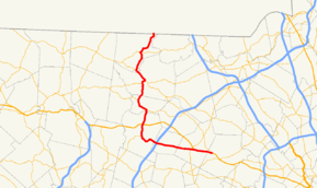
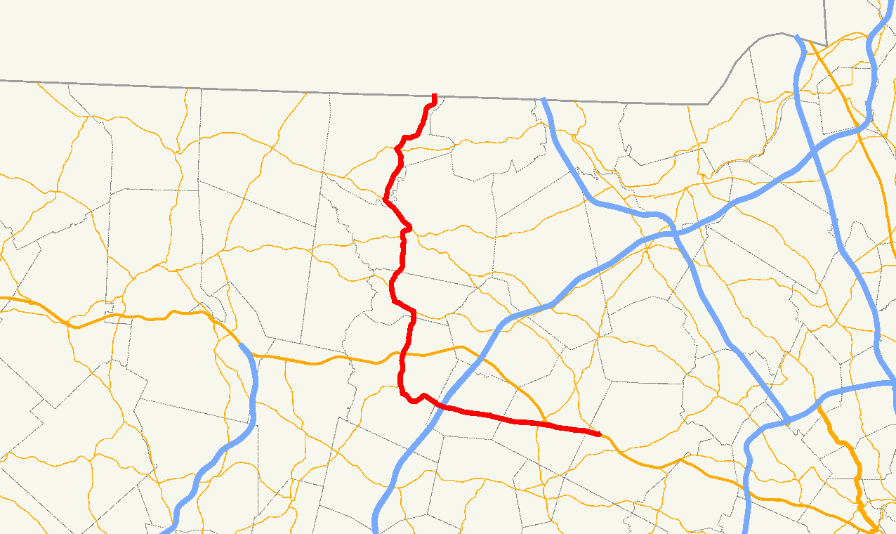
Route information Length: 27.2821 mi[1] (43.9063 km) Existed: 1926 – present Major junctions South end: 

 Routes 2/2A/119 in Concord Route 2 in Harvard
 I-495 in Boxborough
 Routes 119/225 in Groton
North end:  NH Route 111 in Hollis, NH
Highway system Massachusetts State Highway Routes
←  Route 110
Route 112  →
→Route 111 is a state highway in Massachusetts, a continuation of New Hampshire Route 111. The route has a north–south component and an east–west one, though it is signed exclusively as a north–south route on newer signs. The east–west portion of the route largely follows the path of the Union Turnpike, built in the early 19th century to connect the communities of Leominster and Concord. (A few older east–west directional signs still exist east of Harvard.)
Route description
Route 111 begins in Concord at the rotary junction of Route 2, Route 2A and Route 119, next to MCI - Concord. The route is concurrent along Union Turnpike with Route 2 for the first 2.4 miles (3.9 km) into Acton, before Route 2 heads northwestward, beginning its western highway portion. Route 111 continues along Massachusetts Avenue, having a junction with Route 27 not far from the split.
Route 111 continues relatively westward along Massachusetts Avenue through Boxborough, meeting I-495 at Exit 28, just before entering Harvard. In Harvard, the route leaves Massachusetts Avenue at its far western end, looping around until it meets Route 110 at that town's center. The two routes continue northward, crossing Route 2 at exit 38, before continuing northward, west of Fort Devens into Ayer. In Ayer, Route 111 splits from Route 110 as that route turns eastward with Route 2A Eastbound, while Route 111 turns westbound along that route, passing concurrently with it along Ayer's Main Street.
After turning northward again, Routes 111 and 2A split, just west of Moore Army Air Field, with Route 111 turning more northerly into Groton. In Groton, Route 111 joins Route 225 near the center of town, with the two of them meeting Route 119. At this point, Route 225 joins Route 119 eastbound while Route 111 joins Route 119 west bound. The two routes head northwestward and cross the Nashua River into the town of Pepperell concurrently. Once in Pepperell, Route 111 turns northward again, running in roughly the same direction as the river. It crosses Route 113 near the center of Pepperell before continuing northward, finally ending as it enters Hollis, New Hampshire and becomes New Hampshire Route 111.
Junction list

Westbound in West Acton County Location Mile Roads intersected Notes Middlesex Concord 0.00 Route 2
Routes 2A / 119Southern end of Route 111 at junction of Routes 2, 2A & 119.
Beginning of concurrency with Routes 111 and 2.Acton 2.4 Route 2 WestEnd of concurrency with Route 2 at Route 2’s Exit 43. 2.9  Route 27
Boxborough 7.6 I-495I-495 Exit 28. Worcester Harvard 10.3 Route 110 WestBeginning of concurrency with Route 110. 11.9 Route 2Route 2 Exits 38 A-B Middlesex Ayer 14.1 Route 2A / Route 110 EastEnd of concurrency with Route 110.
Beginning of concurrency with Route 2A.15.8 Route 2A WestEnd of concurrency with Route 2A. Groton 18.6 Route 225 WestBeginning of concurrency with Route 225. 19.2 Route 225 East
Route 119 EastEnd of concurrency with Route 225.
Eastbound Route 225 to Route 40.
Beginning of concurrency with Route 119.Pepperell 21.0 Route 119 WestEnd of concurrency with Route 119. 23.8  Route 113
27.28 NH Route 111Northern end of Massachusetts Route 111.
Western end of New Hampshire Route 111.References
- "Massachusetts Atlas and Gazetteer." Yarmouth, Maine: DeLorme. First Edition, 1998.
Categories:- Numbered routes in Massachusetts

Wikimedia Foundation. 2010.