- Adaminaby, New South Wales
-
Adaminaby
New South Wales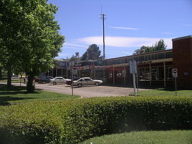
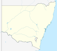
Main street of Adaminaby, New South WalesPopulation: 234(2006 census)[1] Postcode: 2629 Coordinates: 35°59′44.32″S 148°46′28.02″E / 35.9956444°S 148.77445°ECoordinates: 35°59′44.32″S 148°46′28.02″E / 35.9956444°S 148.77445°E Elevation: 1,017 m (3,337 ft) Location: LGA: Snowy River Shire County: Wallace State District: Monaro Federal Division: Eden-Monaro Adaminaby (
 /ædəˈmɪnəbi/)[3] is a small town near the Snowy Mountains located north-west of Cooma, New South Wales, Australia, in the Snowy River Shire.
The historic town, of about 234 people, is a trout fishing centre and winter sports destination situated at 1,017 metres (3,337 ft) above sea level. It is one of the highest towns in Australia, and snowfalls are not uncommon during winter. The construction of nearby Lake Eucumbene made it necessary to re-locate the original Township of Adaminaby in 1957. The present township is located on the Snowy Mountains Highway and is known as the "Home of The Big Trout". In times of drought, the original township and relics of the old valley re-emerge from under the waters of the lake.
Today, Adminaby is a popular destination for horse riders, bushwalkers, fly-fishermen and water sports enthusiasts as well as a base for viewing aspects of the Snowy Mountains Scheme.[4]
Contents
History
The Snowy Mountains region was an important gathering point for the Aborigines of the Adaminaby and surrounding districts for many thousands of years, with inter-tribal summer meetings being held in the High Country involving up to a thousand people for feasting on the Bogong Moth. This practice continued until around 1865.[5]
Man From Snowy River Country
Europeans penetrated the district from the late 1820s and Adaminaby first began to develop as an agricultural centre from the 1830s, with sheep and cattle becoming an economic mainstay.[6] Some historians believe that Banjo Paterson's most famous poem, "The Man From Snowy River", may have been inspired by the exploits of an Adaminaby stockman, Charlie McKeahnie.[7] McKeahnie died in a riding accident in 1895 and is now buried in the Old Adaminaby Cemetery on the shores of Lake Eucumbene. Paterson's character, the Man From Snowy River, is most likely a composite character, based on various people involved in brumby hunts such as were conducted in the Adaminaby district.
Paterson was not the only Australian writer to find inspiration at Adaminaby - the poet Barcroft Boake also wrote about McKeahnie's ride in "On the Range",[8] in which McKeahnie chases down a well bred horse which had escaped with a brumby mob of wild horses; while Nobel Prize winning author Patrick White worked as a jackaroo at Adaminaby's Bolaro Station in the 1930s.
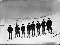
In addition to agriculture, the fortunes of the town were affected by the discovery of gold at nearby Kiandra in 1859 and subsequent introduction of recreational skiing to the district around 1861, when Scandinavian gold prospectors are reputed to have strapped fence posts to their boots and slid down the snowbound hills of a landscape too frozen for mining. Kiandra's ski facilities were permanently shifted "up the hill" to Selwyn Snowfields in 1978 and Adaminaby remains the main service centre for the Northern skifields - one of the oldest areas for recreational skiing in the world.[9]
Early graziers used the high country wilderness above Adaminaby as summer pastureland. The area was set aside as a National Chase in 1906 and later became the Kosciuszko National Park. Today the area is renowned for its historic huts and access to unique wilderness areas, including the Mount Jagungal Wilderness Area.
Relocation of the original township
The most momentous episode in the town's history, came with the construction of the vast network of tunnels and dams of the Snowy Mountains Hydro-Electric Scheme, which began at Adaminaby in 1949.[10] A lake nine times the volume of Sydney Harbour eventually flooded the valley in which the original townsite lay. A prolonged drought saw the ruins of the old township begin to resurface in April 2007,[11][12] attracting the attention of global media - and even comparisons to the mythical city of Atlantis.[13][14][15]
The remarkable story of Adaminaby's relocation was the subject of film produced by the Snowy Mountains Authority Film Unit in 1958, entitled "Operation Adaminaby" (to see clips click here. It was also was the subject of a 2001 documentary by historian Jeannine Baker, entitled "Our Drowned Town", which screened on SBS Television.[16] Entire houses, and even the Commercial Bank Building were transported on the back of trucks and over 100 buildings were re-erected at the new townsite.[4] Transportation of the first house from Old Adaminaby to New Adaminaby (a distance of just six miles) took six days.[17] Today a tourist village has been built around the handful of buildings which were not relocated from the newly created lakeshore at Old Adaminaby.
The current town served as a construction hub during the building of the Snowy Scheme. The distinctive "architecture" of the buildings in the main street, defined by cost and engineering requirements of the time, is similar to the main street of Tallangatta, Victoria, which was reconstructed around the same time and for similar purposes. A Snowy Mountains Scheme Museum is planned to be constructed in the town.[18]
Adaminaby is today a good base from which to view different aspects of the Snowy Scheme, including nearby Lake Eucumbene, Tantangara Dam, Tumut 2 Power Station and Cabramurra, Australia's highest town.[4]
In September, 2007, Adaminaby recognised the 50th anniversary of its move to the new town site. The weekend of remembrance and celebration recognised the physical and emotional trauma exacted by the relocation.[19]
Home of the Big Trout
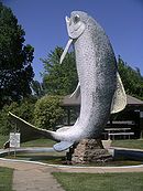
The town is a popular base from which to fish on Lake Eucumbene and surrounding rivers[20] and the town centre features a large sculpture of a trout, standing 10 metres (33 ft) high. Commonly known as the Big Trout, it was one of the earliest of Australia's Big Things and in May 2006, the lake Eucumbene Chamber of Commerce adopted the tourist attraction as a marketing and promotional 'brand'. The Big Trout was built by Andy Lomnici and was restored and repainted by Skins Alive in January 2007, with funding from the Snowy River Shire Council.[21]
Claims to Fame
- Resting place of Charlie McKeahnie, claimed by some as the original "Man From Snowy River".
- Gateway to the Northern NSW Snowfields and Mount Selwyn - the oldest ski district in Australia, where recreational skiing has been conducted since 1861.
- Site where construction of the Snowy Mountains Scheme began in 1949.
- Along with Jindabyne, Talbingo and Tallangatta, Adaminaby is one of a unique collection of Australian towns which were moved to make way for dam construction.
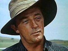
- In 1959 Hollywood came to the newly resituated Adaminaby race course for the filming of "The Sundowners", starring Robert Mitchum, Peter Ustinov, and Deborah Kerr.
- In 1984, the Adaminaby Race Track doubled for Mexico in the Australian horse-bio-pic "Phar Lap (film)", starring Tom Burlinson.
- Home of the World's Largest Trout.
- Site of the Snowy Scheme Museum (Currently under construction).
See also
- Dams
- Skiing in Australia
- Brumby
- Monaro (New South Wales)
References
- ^ Australian Bureau of Statistics (25 October 2007). "Adaminaby (L) (Urban Centre/Locality)". 2006 Census QuickStats. http://www.censusdata.abs.gov.au/ABSNavigation/prenav/LocationSearch?collection=Census&period=2006&areacode=UCL100400&producttype=QuickStats&breadcrumb=PL&action=401. Retrieved 8 June 2009.
- ^ Distances calculated using Travelmate Map Maker
- ^ Macquarie Dictionary, Fourth Edition (2005). Melbourne, The Macquarie Library Pty Ltd. ISBN 1-876429-14-3
- ^ a b c http://www.snowymountains.com.au/Adaminaby.html
- ^ http://www.kiandrahistory.net/indigenous.html
- ^ http://members.ozemail.com.au/~adminaby/admtsm/moving.htm
- ^ http://www.boake.net/display.html
- ^ http://www.boake.net/range.html
- ^ http://www.selwynsnow.com.au/templates/sel/page/page_html_standard.php?secID=69
- ^ http://www.snowymountains.com.au/History.html
- ^ "Old Adaminaby resurfaces in Australian drought". Reuters Photo Slideshows (Reuters). http://www.reuters.com/news/pictures/articleslideshow?articleId=USSP13839920070605. Retrieved 2008-02-18.[dead link]
- ^ Snashall, Richard (2006-08-25). "Sunken Dreams, Adaminiby NSW". ABC Radio. Archived from the original on December 28, 2007. http://web.archive.org/web/20071228115307/http://www.abc.net.au/canberra/stories/s1722131.htm. Retrieved 2007-12-30.
- ^ "Town drowned 50 years ago in Oz re-emerges after drought". Daily Mail (London). 2007-06-05. http://www.dailymail.co.uk/news/article-460131/Town-drowned-50-years-ago-Oz-emerges-drought.html.
- ^ "Lake Eucumbene is down, but the fish are still jumping". The Age (Melbourne). 2007-05-09. http://www.theage.com.au/news/national/lake-eucumbene-is-down-but-the-fish-are-still-jumping/2007/05/08/1178390307890.html.
- ^ http://www.abc.net.au/local/stories/2007/06/08/1943592.htm
- ^ http://www.gzdoc.com/gzdoc2003/en/M_drowned.html
- ^ http://australianscreen.com.au/titles/snowy-hydro-adaminaby/clip1/
- ^ http://www.snowyschemecollection.com.au/Executive_Review.html
- ^ "Adaminaby happily remembers". Lake Eucumbene Chamber of Commerce. http://www.eucumbenechamber.org.au/50thanniversary.html. Retrieved 2007-12-30.
- ^ "Lifestyle". Snowy River Shire Council. http://www.snowyriver.nsw.gov.au/SRSC/LANDING//LIFESTYLE.html. Retrieved 2007-12-30.
- ^ "Meetings". Lake Eucumbene Chamber of Commerce. http://www.eucumbenechamber.org.au/ourchamber.html#aaron. Retrieved 2007-12-30.
External links
- Photos old Adaminaby and new Adaminaby
- Official website of Adaminaby
- Adaminaby page at regional website.
- Listing and history at smh.com
- Lake Eucumbene Chamber of Commerce
- Barcroft Boake poems of Adaminaby and district.
- Snowy Hydro
- [1]
 The creation of Lake Eucumbene made it necessary to re-locate the original town of Adaminaby. The lake has a capacity 9 times that of Sydney Harbour
.
Categories:- Towns in New South Wales
- Australian Aboriginal placenames
- Snowy Mountains Scheme
Wikimedia Foundation. 2010.


