- Buckhannon River
Geobox River
name = Buckhannon River
image_size = 290
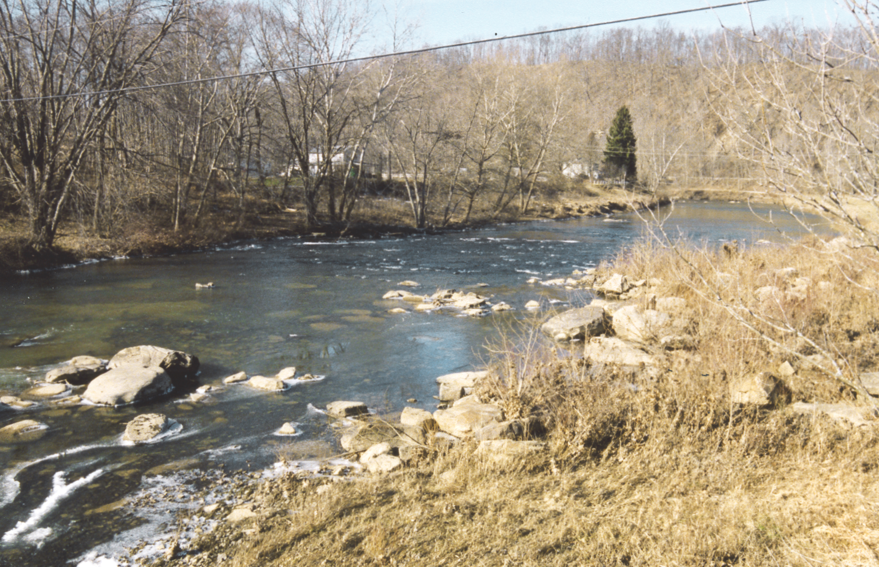
image_caption = The Buckhannon River in Rangoon in 2005
image_first =
country = United States
state = West Virginia
length =
length_imperial = 47
length_note =cite book| last= Howard |first= Kim |editor= Ken Sullivan (ed.) | title= The West Virginia Encyclopedia |year= 2006 |publisher= West Virginia Humanities Council |location=Charleston, W.Va. |isbn= 0-9778498-0-5 |pages= p. 88 |chapter=Buckhannon River]
watershed =
watershed_imperial = 309
watershed_note =cite web |url= http://www.dep.state.wv.us/watershed/ |pages = [http://web.archive.org/web/20060523112218/www.dep.state.wv.us/watershed/w5020001.html Tygart Valley River watershed (cited figures are for sum of Upper and Lower Buckhannon River, French Creek, Finks Run, Sand Run and Pecks Run watersheds)] | title= Watershed Atlas Project. | author= West Virginia Department of Environmental Protection | accessdate=2007-02-26 |archiveurl= http://web.archive.org/web/20050404165853/www.dep.state.wv.us/watershed/ |archivedate=2006-05-07]
discharge_location =
discharge_average =
discharge_average_imperial =
discharge_max =
discharge_max_imperial =
discharge_min =
discharge_min_imperial =
discharge1_location =
discharge1_average =
discharge1_average_imperial =
source_name = Confluence of Left Fork Buckhannon River and Right Fork Buckhannon River
source_location = Alexander, Upshur County
source_location_note =
source_lat_d = 38
source_lat_m = 47
source_lat_s = 03
source_lat_NS = N
source_long_d = 80
source_long_m = 13
source_long_s = 20
source_long_EW = W
source_coordinates_note =cite web |url=Gnis3|1536596 |title=Geographic Names Information System entry for Buckhannon River (Feature ID #1536596) |author=Geographic Names Information System |authorlink=Geographic Names Information System|accessdate=2007-02-26]
source_elevation =
source_elevation_imperial = 1837
source_elevation_note =cite web |url=Gnis3|1551766 |title=Geographic Names Information System entry for Left Fork Buckhannon River (Feature ID #1551766) |author=Geographic Names Information System |authorlink=Geographic Names Information System|accessdate=2007-02-26]
source_length =
source_length_imperial =
source1_name =
source_meet =
mouth_name = Tygart Valley River
mouth_location = southwestern Barbour County
mouth_location_note =
mouth_elevation =
mouth_elevation_imperial = 1325
mouth_elevation_note =
mouth_lat_d = 39
mouth_lat_m = 05
mouth_lat_s = 49
mouth_lat_NS = N
mouth_long_d = 80
mouth_long_m = 04
mouth_long_s = 35
mouth_long_EW = W
mouth_coordinates_note =
tributary_left =
tributary_left1 =
tributary_right =
tributary_right1 =
map_size = 290
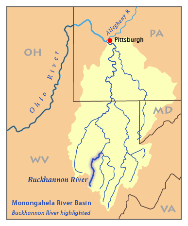
map_caption = Map of theMonongahela River basin, highlighting the Buckhannon River
map_first =The Buckhannon River is a
tributary of theTygart Valley River , about 47 mi (76 km) long, in north-centralWest Virginia in theUnited States . Via the Tygart Valley, Monongahela and Ohio Rivers, it is part of the watershed of theMississippi River , draining an area of 309 square miles (800 km²) on the unglaciated portion of theAllegheny Plateau . It is locally held to have been named forBuckongahelas (d. 1805), aLenape ally of the British during the Revolutionary War; other accounts trace the name to a missionary named John Buchanon who explored the vicinity of the city of Buckhannon in the late 18th century. [cite book| last= Howard |first= Kim |editor= Ken Sullivan (ed.) | title= The West Virginia Encyclopedia |year= 2006 |publisher= West Virginia Humanities Council |location=Charleston, W.Va. |isbn= 0-9778498-0-5 |pages= p. 88-89 |chapter=Buckongahelas] [cite book| last= Howard |first= Kim |editor= Ken Sullivan (ed.) | title= The West Virginia Encyclopedia |year= 2006 |publisher= West Virginia Humanities Council |location=Charleston, W.Va. |isbn= 0-9778498-0-5 |pages= p. 88 |chapter=Buckhannon] The river provides drinking water for much of Upshur County.Geography
The Buckhannon River is formed at the community of Alexander in southern Upshur County by the confluence of the Left Fork Buckhannon River and the Right Fork Buckhannon River, [cite web |url=Gnis3|1552654 |title=Geographic Names Information System entry for Right Fork Buckhannon River (Feature ID #1552654) |author=Geographic Names Information System |authorlink=Geographic Names Information System|accessdate=2007-02-26] both of which rise in southwestern Randolph County at elevations of 3,658 feet (1,116 m) and 3,401 feet (1,037 m), respectively, [
Google Earth elevations forGNIS source coordinates. Retrieved on2007-02-26 .] and flow generally north-northwestwardly into southern Upshur County. The Right Fork flows through the communities of Pickens and Selbyville and collects tributaries known as Middle Fork Right Fork Buckhannon River [cite web |url=Gnis3|1543194 |title=Geographic Names Information System entry for Middle Fork Right Fork Buckhannon River (Feature ID #1543194) |author=Geographic Names Information System |authorlink=Geographic Names Information System|accessdate=2007-02-26] and Left Fork Right Fork Buckhannon River; [cite web |url=Gnis3|1549551 |title=Geographic Names Information System entry for Left Fork Right Fork Buckhannon River (Feature ID #1549551) |author=Geographic Names Information System |authorlink=Geographic Names Information System|accessdate=2007-02-26] the Left Fork of the Right Fork flows through the community of Helvetia.DeLorme (1997). "West Virginia Atlas & Gazetteer". Yarmouth, Maine: DeLorme. ISBN 0-89933-246-3.]From Alexander the Buckhannon River flows generally northwardly, past Sago, to the city of Buckhannon, then northeastwardly into southwestern Barbour County, past Rangoon and Carrollton, where it is crossed by the
Carrollton Covered Bridge . It joins the Tygart Valley River just downstream of Carrollton, approximately four miles (6 km) southwest of Philippi.According to the West Virginia Department of Environmental Protection, approximately 79.5% of the Buckhannon River's watershed is
forest ed, mostlydeciduous ; approximately 18.1% is used foragriculture andpasture ; and less than 1% is urban.Fish life
The uppermost (southernmost) stretch of the river downstream of Alexander drops approximately 400 feet (122 m) in its first thirteen miles (21 km) and is
boulder -strewn, providing habitat fortrout (particularlybrown trout ),smallmouth bass , androck bass . A low dam, installed for the provision of drinking water, forms a pool stretching upstream of Buckhannon to Sago; downstream of Sago, the Buckhannon is considered to be one of the best streams formuskellunge fishing in West Virginia. For twenty miles (32 km) downstream of Buckhannon, the river generally moves slowly between vegetation-covered banks over numerous submerged logs, providing habitat for muskies as well as smallmouth bass, rock bass, andcarp . In its lowermost course above its mouth, the river assumes a higher gradient and is home to smallmouth bass, rock bass, and sunfish.cite journal | last = Shingleton | first = Michael V. | title = Various Fishing Opportunities Await Anglers at the Buckhannon River | journal = Wonderful West Virginia | volume = 60 | issue = 1 | pages = 30–32 | publisher = West Virginia Division of Natural Resources | date = March 1996]Variant names and spellings
According to the
Geographic Names Information System , the Buckhannon River has also been known as:
*Buchanan River
*Buchanon River
*Buckanan River
*Buckhanan River
*Buckhannans Fork
*Buckhanon Riveree also
*
List of West Virginia rivers References
Wikimedia Foundation. 2010.