- Maryport railway station
-
Maryport 

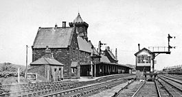
Maryport railway station in 1951 Location Place Maryport Local authority Allerdale Operations Station code MRY Managed by Northern Rail Number of platforms 1 Live arrivals/departures and station information
from National Rail EnquiriesAnnual rail passenger usage 2004/05 * 59,058 2005/06 *  61,408
2006/07 *  60,119
2007/08 *  82,066
2008/09 *  60,458
History Opened 1840 National Rail - UK railway stations A B C D E F G H I J K L M N O P Q R S T U V W X Y Z * Annual passenger usage based on sales of tickets in stated financial year(s) which end or originate at Maryport from Office of Rail Regulation statistics. Please note: methodology may vary year on year. Maryport Railway Station serves the town of Maryport in Cumbria, England. The railway station is a stop on the scenic Cumbrian Coast Line 44 kilometres (27 mi) south west of Carlisle. It is operated by Northern Rail who provide all passenger train services. It is unstaffed (there are no longer any station buildings, just simple waiting shelters) and passengers must buy their ticket on the train. The station is somewhat unusual in that it consists of a single bi-directional platform rather than the usual two side platforms used elsewhere on the double track sections of the Cumbrian Coast line. Southbound trains have to cross over to the northbound line to reach the platform before returning to the correct line south of the station. This can cause delays if two trains are scheduled to call in quick succession or if one or more trains are running late. Network Rail plans to address this issue as part of a future resignalling scheme[1]
Contents
History
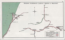
 A 1904 Railway Clearing House Junction Diagram showing (left) railways in the vicinity of Maryport (M&C in pink; LNWR in red)
Two railway companies originally served the town - the Maryport and Carlisle Railway (M&C), which opened the line to Carlisle in stages between 1840 & 1845 and the Whitehaven Junction Railway which ran southwards to Workington & Whitehaven and opened in 1847. The latter company was taken over by the London and North Western Railway (LNWR) in 1866, but the M&C remained independent right up until absorption into the LMS in January 1923.[2]
Service
There is generally an hourly service northbound to Carlisle and southbound to Whitehaven with some trains going forward to Barrow-in-Furness (ten per day) and Lancaster via the Furness Line (four). On Sundays there are three trains each way to Carlisle and Whitehaven only.
In the aftermath of the 2009 Cumbria floods, an additional hourly shuttle service operated southbound stopping at stations to Workington. All services between Workington, Workington North, Flimby and Maryport were free of charge until this service was terminated on 28 May 2010.
Notes
External links
- Train times and station information for Maryport railway station from National Rail
Preceding station  National Rail
Following station Northern Rail Coordinates: 54°42′43″N 3°29′42″W / 54.712°N 3.495°W
Categories:- North West England railway station stubs
- Railway stations in Cumbria
- Former Maryport and Carlisle Railway stations
- Railway stations opened in 1840
- Railway stations served by Northern Rail
- DfT Category F2 stations
Wikimedia Foundation. 2010.
