- Mount Pleasant, Western Australia
-
Mount Pleasant
Perth, Western Australia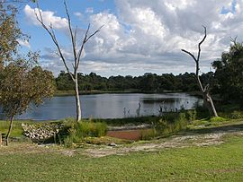

 Mount Pleasant
Population: 6423 (2006 census)[1] Established: 1911 Postcode: 6153 LGA: City of Melville State District: Alfred Cove Federal Division: Tangney Suburbs around Mount Pleasant: Applecross Applecross Como Ardross Mount Pleasant Salter Point Booragoon Brentwood Rossmoyne Coordinates: 32°01′37″S 115°50′53″E / 32.027°S 115.848°E
Mount Pleasant is a suburb of Perth, Western Australia, located within the City of Melville on the Canning River.
Mount Pleasant hosts the Head of the River Rowing event, as part of the Public Schools Association, an elite boys schools association in Perth.
Photos of the suburb
-
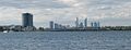
Canning Bridge and Perth CBD as viewed from Mount Pleasant
-
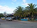
Queens Street shopping precinct
-

Mount Henry Bridge, taken from Deep Water Point
References
- ^ Australian Bureau of Statistics (25 October 2007). "Mount Pleasant (State Suburb)". 2006 Census QuickStats. http://www.censusdata.abs.gov.au/ABSNavigation/prenav/LocationSearch?collection=Census&period=2006&areacode=SSC51991&producttype=QuickStats&breadcrumb=PL&action=401. Retrieved 2008-10-05.
Suburbs of the City of Melville | Perth | Western Australia Categories:- Suburbs of Perth, Western Australia
- Canning River (Western Australia)
- Perth, Western Australia geography stubs
-


Wikimedia Foundation. 2010.