Champion Lakes, Western Australia

Champion Lakes, Western Australia
Champion Lakes
PerthWestern Australia
Champion Lakes bridge, WA, SMC 2007, .jpg
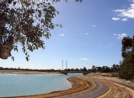
Regatta Centre under construction
Champion Lakes is located in Perth
{{{alt}}}
Champion Lakes
Population: 520 (2006 census)
Established: 2002
Postcode: 6111
Area: 5.0 km² (1.9 sq mi)
Location:
LGA: City of Armadale
State District: Armadale
Federal Division: Canning
Suburbs around Champion Lakes:
Gosnells Gosnells Martin
Southern River Champion Lakes Camillo
Forrestdale Seville Grove Camillo

Coordinates: 32°07′12″S 115°59′02″E / 32.12°S 115.984°E / -32.12; 115.984

Champion Lakes is a suburb of Perth, Western Australia, located within the City of Armadale.

The suburb was originally part of Westfield, but was renamed along with the proposal for a large water-based recreation facility to be constructed in the area.

References


Wikimedia Foundation. 2010.

Игры ⚽ Поможем написать реферат

Look at other dictionaries:

  • Champion Lakes Regatta Centre — Champion Lakes …   Wikipedia

  • Mount Richon, Western Australia — Mount Richon Perth, Western Australia …   Wikipedia

  • Mount Nasura, Western Australia — Mount Nasura Perth, Western Australia …   Wikipedia

  • Clifton Hills, Western Australia — Cliffton Hills Perth, Western Australia 270px Sunset over Perth from the Darling Range [1] Established: 1869 …   Wikipedia

  • Seville Grove, Western Australia — Infobox Australian Place | type = suburb name = Seville Grove city = Perth state = wa caption = lga = City of Armadale postcode = 6112 pop = 7,065 (2006 census) area = 4.3 est = 1990s propval = $332,000 (Q1 2007) cite… …   Wikipedia

  • Country Senior High Schools Carnival (Western Australia) — Country Week or Country Senior High Schools Carnival is an annual multi sport event carnival held in Perth, Western Australia between rural high schools from Western Australia. The carnival is organised by School Sport WA. The carnival includes… …   Wikipedia

  • Westfield, Western Australia — Infobox Australian Place | type = suburb name = Westfield city = Perth state = wa caption = lga = City of Armadale postcode = 6111 pop = 4,523 (2006 census) area = 2.5 est = propval = $283,000 (Q1 2007) cite web|url=http://reiwa.com/res/res… …   Wikipedia

  • List of road routes in Perth, Western Australia — This is a list of the road routes in Perth, Western Australia. A list of road routes in Rural Western Australia is available at List of road routes in rural and remote Western Australia.For a list of freeways, highways and roads, see List of… …   Wikipedia

  • Kelmscott, Western Australia — Infobox Australian Place | type = suburb name = Kelmscott city = Perth state = wa caption = lga = City of Armadale postcode = 6111 pop = 9,417 (2006 census) area = 15.9 est = propval = $333,000 (Q1 2007) cite web|url=http://reiwa.com/res/res… …   Wikipedia

  • Gosnells, Western Australia — Infobox Australian Place | type = suburb name = Gosnells city = Perth state = wa caption = lga = City of Gosnells postcode = 6110 est = pop = 17,277 pop footnotes = (2006) [Census 2006 AUS|id=SSC51541|name=Gosnells (State Suburb)|accessdate=2008… …   Wikipedia

Share the article and excerpts

Direct link
Do a right-click on the link above
and select “Copy Link”