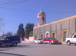
- Allende, Coahuila
-
Allende, Coahuila Coordinates: 28°20′N 100°50′W / 28.333°N 100.833°WCoordinates: 28°20′N 100°50′W / 28.333°N 100.833°W Country  Mexico
State Coahuila Municipality Allende Founded 16 March 1826 Government – Mayor Ricardo Alfonso Treviño Guevara Area – Municipality 198.70 km2 (76.7 sq mi) Elevation 380 m (1,247 ft) Population (2000) – Metro 20,153 (municip) Time zone CST (UTC-6) Postal code 26531 Area code(s) 862 Website www.allendecoahuila.gob.mx Allende is a city in the Mexican state of Coahuila. The city serves as the administrative centre for the surrounding municipality of Allende.
Contents
History
The name "Allende" is in honour of Ignacio Allende, a hero of Mexico's War of Independence. The town's folk hero is Arnulfo González who was gunned down in the mid 1920s, and has a "corrido" sung by artists such as Vicente Fernández and many others. Prior to 1832 the settlement was known as San Juan de Mata.
Geography
The city of Allende is located at 28°20′30″N 100°50′2″W / 28.34167°N 100.83389°W, at a height of 380 meters (1,250 ft) above sea level. It straddles Federal Highway 57, with state capital Saltillo some 390 kilometers (240 mi) away to the south, while the international border crossing at Piedras Negras, Coahuila (across the Río Bravo del Norte from Eagle Pass, Texas, USA) is some 55 kilometers (34 mi) to the north. Allende is also crossed by the railway that connects Saltillo to the border city of Ciudad Acuña (across the river from Del Rio, Texas, USA).
Allende municipality covers a total surface area of 198.70 square kilometers (76.72 sq mi) and, in 2000, reported a total population of 20,153. The town's annual festival (fiesta patronal) takes place on 29 August. In addition to the municipal seat, the only other two settlements of any size in the municipality are Río Bravo and Chamucero.
References
External links
Media
XHWDT 48 (Canal de las Estrellas)
Coahuila Broadcast television areas by city: Allende • Ciudad Acuña • Nueva Rosita • Monclova • Parras de la Fuente • Piedras Negras • Sabinas • Saltillo • Torreon
See also Television stations in CoahuilaSaltillo (capital)Topics Architecture · Climate · Culture · Demographics · Economy · Education · Geography · Government · History · Literature · Politics · Sports · Transportation · Tourist Attractions

Municipalities
and
(municipal seats)Abasolo (Abasolo) · Acuña (Ciudad Acuña) · Allende (Allende) · Arteaga (Arteaga) · Candela (Candela) · Castaños (Castaños) · Cuatrociénegas (Cuatrociénegas de Carranza) · Escobedo (Escobedo) · Francisco I. Madero (Francisco I. Madero) · Frontera (Ciudad Frontera) · General Cepeda (General Cepeda) · Guerrero (Guerrero) · Hidalgo (Hidalgo) · Jiménez (Jiménez) · Juárez (Juárez) · Lamadrid (Lamadrid) · Matamoros (Matamoros de la Laguna) · Monclova (Monclova) · Morelos (Morelos) · Múzquiz (Santa Rosa de Múzquiz) · Nadadores (Nadadores) · Nava (Nava) · Ocampo (Ocampo) · Parras (Parras de la Fuente) · Piedras Negras (Piedras Negras) · Progreso (Progreso) · Ramos Arizpe (Ramos Arizpe) · Sabinas (Sabinas) · Sacramento (Sacramento) · Saltillo (Saltillo) · San Buenaventura (San Buenaventura) · San Juan de Sabinas (Nueva Rosita) · San Pedro de las Colonias (San Pedro de las Colonias) · Sierra Mojada (Sierra Mojada) · Torreón (Torreón) · Viesca (Viesca) · Villa Unión (Villa Unión) · Zaragoza (Zaragoza)
Categories:- Populated places in Coahuila
Wikimedia Foundation. 2010.


