- Porsanger
Infobox_Kommune
name=Porsanger
alt_names_last=Porsáŋggu gielda Porsangin komuuni
idnumber=2020
county=Finnmark
landscape=
capital=Lakselv
governor=Bjørn Kåre Søderholm (H)
governor_as_of=2004
arearank=3
area=4873
arealand=4643
areapercent=1.51
population_as_of=2008
populationrank=221?
population=4,059
populationpercent=0.0
populationdensity=0.9
populationincrease=-8.2
language=Bokmål, Sami, and Kven
lat_deg=70| lat_min=1| lat_sec=7| lon_deg=25| lon_min=1| lon_sec=25
utm_zone=35W| utm_northing=7769191 |utm_easting=0424643| geo_cat=adm2nd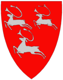
munwebpage=www.porsanger.noPorsanger (Norwegian) or Porsáŋgu (
Northern Sami ) or Porsanki (Kven/Finnish) is a municipality in the county ofFinnmark ,Norway . Since 2004 the municipality has had three official names: Porsanger, Porsáŋgu, and Porsanki.Porsanger (until 1964 named
Kistrand ) was established as a municipality January 1, 1838 (seeformannskapsdistrikt ). Three other municipalities were later separated from it:Kautokeino (1851),Nordkapp (1861) andKarasjok (1866).Facts
Porsanger is the third largest municipality by area, with 4.873 km2. The fjord is the fourth longest in Norway, and the longest in North Norway. Based here is the northernmost winery, using crowberries instead of grapes.
Midnight sun from 16 May to 27 July. Polar night from 25 November to 16 January.
Population
With a population of 4100 people, many with
Kven (Kainu) or Sami background. The population decreases slowly with 0-8% according to the municipality statistics, taken yearly.Geography
The municipality is on the shores of the
fjord Porsangen , a wide, open body of water with many islands. The biggest settlement and administrative centre is the town ofLakselv at the fjord's end, but there are smaller hamlets spread around on both sides, notably Kistrand, Olderfjord,Børselv and Billefjord.On the western side of the fjord, one finds the
Stabbursdalen National Park , with the world's northernmostpine forest.History
The area has been settled by Sami since time immemorial. In the 18th century people from
Finland , escaping famine and war, settled along the fjord. These people are today known asKven . Today, three official languages are in use, and the municipality is named "Porsanger", "Porsáŋgu" and "Porsanki" (the name in respectively Norwegian,Northern Sami and Kven/Finnish).Economy
Lakselv Airport, Banak has connections toTromsø andKirkenes operated byWiderøe , as well as charter flights in the summer season. The airport is also used by the Norwegian air force'sStation Group Banak , and with the Norwegian army's garrison at Porsangmoen, the military presence is quite heavy.Local newspapers are
Finnmark Dagblad andSágat .The name
The Norse form of the name was "Porsangr". The first element is probably the name of the plant "pors"/"finnmarkspors" (
Ledum palustre ). (Another theory is that is comes from Sami "borsi" 'waterfall'.) The last word is "angr" 'fjord'.Coat-of-arms
The coat-of-arms is from 1967. It shows three
reindeer .(See also the coat-of-arms of
Eidfjord ,Rendalen ,Tromsø ,Vadsø andVågå .)Birdlife
Porsanger is an area of rich and varied bird fauna. The Stabbursdalen National Park can be found within the municipality, a site of international importance with the worlds northernmost pine forests. Here one can find such species as
Pine Grosbeak . Away from the woodlands, it is the surrounding wetlands that have the greatest diversity. During spring thousands ofRed Knot stop to rest and feed along the shores of Porsangerfjord.External links
* [http://www.porsanger.com/ Porsanger.com]
* [http://museumsnett.no/stabbursnes/engelsk.htm Stabbursnes nature house and museum]
* [http://www.stabbursdalen.no Angling in Porsanger]
Wikimedia Foundation. 2010.