- Ouattagouna
-
Ouattagouna — Commune and town — Location in Mali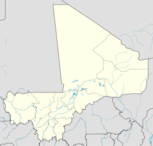
 Ouattagouna
Coordinates: 15°11′03″N 0°43′18″E / 15.18417°N 0.72167°ECoordinates: 15°11′03″N 0°43′18″E / 15.18417°N 0.72167°E Country  Mali
MaliRegion Gao Region Cercle Ansongo Cercle Government – Mayor Amadou Harouna Maiga Area[1] – Commune and town 4,093 km2 (1,580.3 sq mi) Population (2009 census)[2] – Commune and town 30,519 – Metro 3,591 Time zone GMT (UTC+0) Ouattagouna or Ouatagouna is a small town and commune in the Cercle of Ansongo in the Gao Region of south-eastern Mali.
Contents
Geography and climate
Located in the extreme south of the Ansongo Cercle and the region, the commune of Ouattagouna was established by Law No. 096-059, on 4 November 1996.[1] It is bounded to the north by the communes of Boura and Tin-Hama, south by the prefecture Tilabery of Niger, to the east by the town of Tin-Hama and Menaka and west by the municipality of Tessit. It covers an area of 4093 square kilometers.[1] A considerable amount of the commune lies in the Ansongo-Ménaka animal reserve, especially east of the main town. It is managed by 23 elected representatives including one woman, three in the cercle and one in the Regional Assembly headed by a Mayor, three assistants, a secretary general, a manager and a guard.
The relief of Ouattagouna is very rugged with a few hills located near Ankoum Migno and El Mack (Bintia in Hausa). Several rocky cliffs along the valley flanks the Niger River. The climate is Sahelian and is characterized by three distinct seasons, dry and cold from October to March; a hot season from April to May; and a rainy season from June to September.[1] The commune experiences prevailing harmattan dry winds blowing for eight to nine months followed by the monsoon which is a humid wind blowing from July to September.[1]
The average rainfall ranges from 250 to 300 mm per year and the temperature fluctuates between 10 °C and 30 °C.[1] However rainfall may fluctuate, for instance from 1997 to 2002, the total ranged from 129.5 mm in 10 days in 1997 and 429.2 mm in 1999. In 2002 it was 208.4 mm in a 18 day period against 307 mm in 23 days in 2001 and 383.3 mm in 24 days in 2004 etc.[1] The Niger River passes through the commune for about 50 kilometres. Several wadis runoff into the river including the Kamgala, Soror, Bolilam in Hausa, then that of Imminan in the Gourma.
The commune of Ouattagouna contains several small lakes, the most important being Afrag, Barguvi, Tamakazène, Soror Koutou, Tirrazir, Tikoubaradène, Tangouba, Tin Chiguéren, Tinibit, Petan Tibanguir, Gardabani, Tabakatt, Darous Bangou and others.[1] Vegetation is mainly influenced by climate and is composed primarily of savannah grassland. The land is characterised by very deep clay and sandy soils, suitable for agriculture and growing vegetables along the Niger River, and the soils can give a red-brown color in sub-arid regions.[1]
Wildlife
The "Ansongo-Ménaka Nature Reserve", established in the years 1956-1960 takes up much of the land in the commune of Ouattagouna. The reserve was created to protect a variety of wildlife including among others elephants, giraffes, gazelles, panthers, lions, tigers, hyenas, oryx, ostriches, turtles, boas, porcupines, hippos, ducks, herons, geese, jackals, monkeys, hyenas, manatees, crocodiles, lizards etc.[1] Also, the presence of the rich fauna has led to the construction of a tourist camp Fafa but poaching and bush fires have threatened conservation in the region.[1] The commune has a notable abundance of fish and the town has a high rate of fish production. However, common drought, flooding and over-exploitation of fish stocks have seen catches fall sharply in quantity and quality in recent years.[1]
Villages
The commune contains the following settlements:[3]
References
- ^ a b c d e f g h i j k l (in French) Plan de Sécurite Alimentaire Commune Rurale de Ouatagouna 2005-2009, Commissariat à la Sécurité Alimentaire, République du Mali, USAID-Mali, 2005, http://www.aec.msu.edu/fs2/mali_fd_strtgy/plans/gao/Ansongo/P_S_A_Ouatagouna_vf.pdf.
- ^ (in French) Resultats Provisoires RGPH 2009 (Région de Gao), République de Mali: Institut National de la Statistique, http://instat.gov.ml/documentation/gao.pdf.
- ^ (in French) Monographie de la commune de Outtagouna, Ministère de l'Environment République du Mali, http://www.environnement.gov.ml/uploads/sifor/monographie/monoouatta%20fin.pdf, retrieved 14 February 2009
 Communes and towns of the Gao RegionCapital:Gao
Ansongo Cercle Ansongo (Ansongo) · Bara (Bara) · Bourra (Tassiga) · Ouattagouna (Ouattagouna) · Talataye (Talataye) · Tessit (Tessit) · Tin-Hama (Tin-Hama)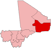
Bourem Cercle Gao Cercle Ménaka Cercle Categories:- Populated places in the Gao Region
- Communes of Mali


Wikimedia Foundation. 2010.