- Ormideia
-
Ormideia
ΟρμήδειαLocation in Cyprus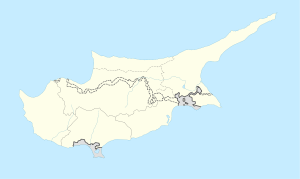
 Ormideia
Coordinates: 34°59′33″N 33°46′49″E / 34.9925°N 33.78028°ECoordinates: 34°59′33″N 33°46′49″E / 34.9925°N 33.78028°E Country  Cyprus
District Larnaca District Municipality Population (2001)[1] - Total 3,960 Time zone EET (UTC+2) - Summer (DST) EEST (UTC+3) Ormideia (Greek: Ορμήδεια), sometimes also rendered Ormidhia is a village in Larnaca District in south-eastern Cyprus. It is one of the three exclaves surrounded by the Eastern Sovereign Base Area of Akrotiri and Dhekelia, a British Overseas Territory administered as a Sovereign Base Area. The others are the village of Xylotymvou and Dhekelia Power Station. It is administered by the internationally recognized government of Cyprus, i.e. the Republic of Cyprus.
References
Larnaca District Settlements Agia Anna • Agioi Vavatsinias • Agios Thedoros • Alaminos • Alethriko • Anafotida • Anglisides • Aplanta • Aradippou • Arsos • Athienou • Avdellero • Choirokoitia • Delikipos • Dromolaxia • Kalavasos • Kalo Chorio • Kato Drys • Kellia • Kiti • Kivisili • Klavdia • Kofinou • Kornos • Lageia • Larnaca • Lefkara • Livadia • Louroujina • Mari • Maroni • Mazotos • Melini • Melouseia • Meneou • Menogeia • Mosfiloti • Odou • Ora • Ormideia • Oroklini • Pergamos • Perivolia • Petrofani • Psematismenos • Psevdas • Pyla • Pyrga • Skarinou • Softades • Tersefanou • Tochni • Tremetousia • Troulloi • Vavatsinia • Vavla • Xylofagou • Xylotymvou • Zygi Categories:
- Cyprus geography stubs
- Populated places in Larnaca District
- Enclaves
- Exclaves

Wikimedia Foundation. 2010.