- Old King's Head Hotel, Chester
-
Coordinates: 53°11′15″N 2°53′26″W / 53.1874°N 2.8905°W
Old King's Head Hotel, Chester 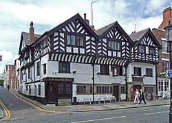 Old King's Head Hotel, Chester
Location: Lower Bridge Street, Chester, Cheshire, England OS grid reference: SJ 406 660 Built: c. 1208 Built for: Peter the Clerk Listed Building – Grade II* Designated: 28 July 1955 Reference #: 1376307 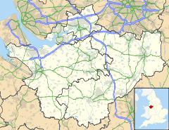
 Location in Cheshire
The Old King's Head Hotel, Chester, is a hotel and public house located at 48–50 Lower Bridge Street, on the corner of Castle Street, Chester, Cheshire, England. It has been designated by English Heritage as a Grade II* listed building.[1]
History
The building was constructed in about 1208.[1] It was the town house for Peter the Clerk, the administrator of Chester Castle.[2] It initially contained a section of the Chester Rows, but these were enclosed during the alterations made between the 15th and early 17th centuries. The latest of these alterations were made for Randle Holme I.[1] The building was restored in 1935,[1] and again during the 1960s.[2]
Architecture
It is basically a timber-framed building, part of which has been refaced with yellow sandstone, and with brick that has been painted or rendered. The roofs are slated. The building is in three storeys, of which the upper storey facing Lower Bridge Street is jettied. Both faces have three bays. The three bays on Lower Bridge Street are gabled, as is the middle bay on Castle Street.[1]
References
- ^ a b c d e The Old Kings Head Hotel, Chester (1376307). National Heritage List for England. English Heritage. Retrieved 30 October 2011.
- ^ a b Langtree, Stephen; Comyns, Alan, eds. (2001), 2000 Years of Building: Chester's Architectural Legacy, Chester: Chester Civic Trust, p. 63, ISBN 0-9540152-0-7
Categories:- Buildings and structures in Chester
- Grade II* listed buildings in Cheshire
- Public houses in Cheshire
- Timber framed buildings
- Medieval architecture


Wikimedia Foundation. 2010.