- Ochtum
-
Ochtum 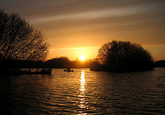
Sunset over the Ochtum near Bremen
Data Location Lower Saxony/Bremen,  Germany
Length 25.6 km Source Confluence of the Hache and Süstedter Bach in the Kirchweyher See
52°59′49″N 8°52′47″E / 52.99694°N 8.87961°ECoordinates: 52°59′49″N 8°52′47″E / 52.99694°N 8.87961°ESource height 5 m Mouth between Lemwerder-Altenesch and Bremen-Seehausen into the Weser
53°07′36″N 8°38′49″E / 53.12669°N 8.64693°EMouth height 2 m Descent 3 m Basin Weser Progression Weser → North Sea Left tributaries Hombach, Stuhrgraben, Varreler Bäke, Delme Cities Bremen Population in catchment 251000 [1] The Ochtum is a left tributary of the Weser, roughly 26 km long, in Lower Saxony and Bremen (Germany).
Contents
Course
The Ochtum starts in Lower Saxony only a few kilometres south of the city of Bremen near Weyhe at the confluence of the Süstedter Bach and the Hache in the lake known as the Kirchweyher See. The Ochtum forms its tailwater and heads in a northwesterly direction into the state of Bremen where it forms part of its border with Lower Saxony. The river flows through or passes the villages and suburbs of Kattenesch, Huchting and Strom, crosses the Park links der Weser and the Ochtumniederung bei Brokhuchting nature reserve. A second branch of the Ochtum – its original channel– runs north past Grolland and joins the main river in the nature reserve. The Ochtum passess Delmenhorst-Hasbergen and Lemwerder-Deichshausen and discharges into the Weser at river kilometre 12.85 between Lemwerder-Altenesch and Bremen-Seehausen near Unterweser.
History
- 1158 – The Ochtum is first mentioned as Ochtmund (= Ochtum mouth). Later also recorded as Ochen, Ochtmoni or Oggen.
- 1234 – Battle of Altenesch
- 1400 – First regulations about the Ochtum
- 1571 – Breach of the Ochtum dyke
- 1833 – Im Warfelde the Ochtum is diverted along a side channel, which gets rid of a large number of bends. Water flow improves.
- 1881 - During a time of very high water the Middle Weser bursts the dyke near Hoya, so that a large amount of floodwater is led away by the Ochtum.
- 1962 - the depression around the Ochtum is completely flooded by the North Sea on 16/17 February and Bremen is separated from the district of Bremen-Huchting. In Huchting several people die in the allotments occupied by folk whose homes had been bombed during the war.
- 28 January 1966 – An aeroplane belonging to the German airline Lufthansa crashed near the Ochtum after an aborted landing at Bremen Airport. All 46 passengers and crew died.
- 1973 - In November and December 1973 several storm surges caused serious damage in the area between the mouth and Huchting. One person died.
- 1976 - In January two very severe storm surges caused heavy damage between Huchting and the mouth of the Ochtum. During the storm surge of 3 January 1976 similar water levels were reached to those in the February floods of 1962.
- 2 June 1976 – Completion of the Ochtum Barrage near Altenesch, for which the Lower Saxon State Department for Waterways, Coastal and Nature Conservation (Niedersächsische Landesbetrieb für Wasserwirtschaft, Küsten- and Naturschutz or NLWKN) is responsible. The old port on the Ochtum was moved to its present location below the Ochtum barrage.
- 1989/1990 – Diversion of a 5.4 km long section of the Ochtum through the Park links der Weser, so that the runway at Bremen Airport can be fully utilised. The roughly 5 km long old branch of the Ochtum north of Grolland has been left in place.
Water quality
According to the 2000 water quality map by the state of Bremen the Ochtum is classified as Class II, moderately polluted, as far as the district of Bremen-Strom.
Economy
Importances as a transport route
The Ochtum is used by water sports clubs. The paths on the Ochtum dykes are popular with cyclists and inline skaters.
References
- ^ Flussgebietsgemeinschaft Weser: Bewirtschaftungsplan Flussgebietseinheit Weser 2005 – Bestandsaufnahme Teilraum Tideweser
External links
- Ochtum Association (German)
- Ochtum (German)
- NLWK office at Sulingen: Ochtum (German)
Categories:- Ochtum drainage basin
- Rivers of Lower Saxony
- Rivers of Bremen
Wikimedia Foundation. 2010.