- Tabas Airport
-
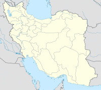
Tabas Airport IATA: TCX – ICAO: OIMT Location of airport in Iran Summary Airport type Public Operator Government Location Tabas, Iran Elevation AMSL 2,312 ft / 705 m Coordinates 33°40′03″N 056°53′33″E / 33.6675°N 56.8925°E Runways Direction Length Surface m ft 15/33 3,041 9,977 Asphalt Source: DAFIF[1][2] Tabas Airport (IATA: TCX[2], ICAO: OIMT[1]) is an airport serving Tabas,[3] a city in the Yazd Province of central Iran.
References
- ^ a b Airport information for OIMT at World Aero Data. Data current as of October 2006.Source: DAFIF.
- ^ a b Airport information for TCX at Great Circle Mapper. Source: DAFIF (effective Oct. 2006).
- ^ Tabas Airport (TCX/OIMT) - Tabas, Iran. Handbook of Business Aviation. Retrieved 16 July 2009.
External links

This article about an Iranian airport is a stub. You can help Wikipedia by expanding it.

