- Nurimanovsky District
-
Nurimanovsky District (English)
Нуримановский район (Russian)
Нуриман районы (Bashkir)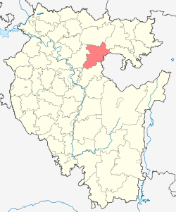
Location of Nurimanovsky District on the map of the Republic of Bashkortostan

Coat of arms Flag Administrative status (as of 2009) Country Russia Federal subject Republic of Bashkortostan[1] Administrative center selo of Krasnaya Gorka[2] Statistics Area (2007) 2,511.84 km2 (969.83 sq mi)[3] Population (2010 Census,
preliminary)20,822 inhabitants[4] Population (2002 Census) 21,932 inhabitants[5] - Urban population 30.2% - Rural population 69.8% Density 8 /km2 (21 /sq mi)[6] Time zone YEKST (UTC+06:00)[7] Established August 1930[3] Nurimanovsky District (Russian: Нуримановский райо́н; Bashkir: Нуриман районы) is an administrative and municipal district (raion), one of the fifty-four in the Republic of Bashkortostan, Russia. It is located in the northeastern part of the republic and borders with Karaidelsky District in the north, Chelyabinsk Oblast in the east, Iglinsky District in the south, and Blagoveshchensky District in the west. The area of the district is 2,511.84 square kilometers (969.83 sq mi).[3] Its administrative center is the rural locality (a selo) of Krasnaya Gorka.[2] District's population: 20,822 (2010 Census preliminary results);[4] 21,932 (2002 Census);[2] 23,371 (1989 Census).[8] Population of Krasnaya Gorka accounts for 18.6% of the district's population.[2]
The district was established in August 1930.[3]
References
- ^ Constitution, Article 64
- ^ a b c d Федеральная служба государственной статистики (Federal State Statistics Service) (2004-05-21). "Численность населения России, субъектов Российской Федерации в составе федеральных округов, районов, городских поселений, сельских населённых пунктов – районных центров и сельских населённых пунктов с населением 3 тысячи и более человек (Population of Russia, its federal districts, federal subjects, districts, urban localities, rural localities—administrative centers, and rural localities with population of over 3,000)" (in Russian). Всероссийская перепись населения 2002 года (All-Russia Population Census of 2002). Federal State Statistics Service. http://www.perepis2002.ru/ct/doc/1_TOM_01_04.xls. Retrieved 2010-03-23.
- ^ a b c d Территориальный орган федеральной службы государственной статистики по Республике Башкортостан. Нуримановский район (Russian)
- ^ a b Федеральная служба государственной статистики (Federal State Statistics Service) (2011). "Предварительные итоги Всероссийской переписи населения 2010 года (Preliminary results of the 2010 All-Russian Population Census)" (in Russian). Всероссийская перепись населения 2010 года (All-Russia Population Census of 2010). Federal State Statistics Service. http://www.perepis-2010.ru/results_of_the_census/results-inform.php. Retrieved 2011-04-25.
- ^ Федеральная служба государственной статистики (Federal State Statistics Service) (2004-05-21). "Численность населения России, субъектов Российской Федерации в составе федеральных округов, районов, городских поселений, сельских населённых пунктов – районных центров и сельских населённых пунктов с населением 3 тысячи и более человек (Population of Russia, its federal districts, federal subjects, districts, urban localities, rural localities—administrative centers, and rural localities with population of over 3,000)" (in Russian). Всероссийская перепись населения 2002 года (All-Russia Population Census of 2002). Federal State Statistics Service. http://www.perepis2002.ru/ct/doc/1_TOM_01_04.xls. Retrieved 2010-03-23.
- ^ The value of density was calculated automatically by dividing the 2010 Census population by the area specified in the infobox. Please note that this value may not be accurate as the area specified in the infobox does not necessarily correspond to the area of the entity proper or is reported for the same year as the population.
- ^ Правительство Российской Федерации. Постановление №725 от 31 августа 2011 г. «О составе территорий, образующих каждую часовую зону, и порядке исчисления времени в часовых зонах, а также о признании утратившими силу отдельных Постановлений Правительства Российской Федерации». Вступил в силу по истечении 7 дней после дня официального опубликования. Опубликован: "Российская Газета", №197, 6 сентября 2011 г. (Government of the Russian Federation. Resolution #725 of August 31, 2011 On the Composition of the Territories Included into Each Time Zone and on the Procedures of Timekeeping in the Time Zones, as Well as on Abrogation of Several Resolutions of the Government of the Russian Federation. Effective as of after 7 days following the day of the official publication).
- ^ "Всесоюзная перепись населения 1989 г. Численность наличного населения союзных и автономных республик, автономных областей и округов, краёв, областей, районов, городских поселений и сёл-райцентров. (All Union Population Census of 1989. Present population of union and autonomous republics, autonomous oblasts and okrugs, krais, oblasts, districts, urban settlements, and villages serving as district administrative centers.)" (in Russian). Всесоюзная перепись населения 1989 года (All-Union Population Census of 1989). Demoscope Weekly (website of the Institute of Demographics of the State University—Higher School of Economics. 1989. http://demoscope.ru/weekly/ssp/rus89_reg.php. Retrieved 2010-03-23.
Sources
- 24 декабря 1993 г. «Конституция Республики Башкортостан», в ред. Закона №146-з от 13 июля 2009 г «О внесении изменений и дополнений в Конституцию Республики Башкортостан». Опубликован: "Ведомости Верховного Совета и Правительства Республики Башкортостан", №4-22, ст.146, 1994. (December 24, 1993 Constitution of the Republic of Bashkortostan, as amended by the Law #146-z of July 13, 2009 On Amending and Supplementing the Constitution of the Republic of Bashkortostan. ).
Administrative divisions of the Republic of Bashkortostan Capital: UfaCities and towns 

Administrative districts - Abzelilovsky
- Alsheyevsky
- Arkhangelsky
- Askinsky
- Aurgazinsky
- Bakalinsky
- Baltachevsky
- Baymaksky
- Belebeyevsky
- Belokataysky
- Beloretsky
- Birsky
- Bizhbulyaksky
- Blagovarsky
- Blagoveshchensky
- Burayevsky
- Burzyansky
- Buzdyaksky
- Chekmagushevsky
- Chishminsky
- Davlekanovsky
- Duvansky
- Dyurtyulinsky
- Fyodorovsky
- Gafuriysky
- Iglinsky
- Ilishevsky
- Ishimbaysky
- Kaltasinsky
- Karaidelsky
- Karmaskalinsky
- Khaybullinsky
- Kiginsky
- Krasnokamsky
- Kugarchinsky
- Kushnarenkovsky
- Kuyurgazinsky
- Mechetlinsky
- Meleuzovsky
- Mishkinsky
- Miyakinsky
- Nurimanovsky
- Salavatsky
- Sharansky
- Sterlibashevsky
- Sterlitamaksky
- Tatyshlinsky
- Tuymazinsky
- Uchalinsky
- Ufimsky
- Yanaulsky
- Yermekeyevsky
- Zianchurinsky
- Zilairsky
Categories:- Districts of Bashkortostan
- States and territories established in 1930

Wikimedia Foundation. 2010.