Nuneaton Urban Area

Nuneaton Urban Area
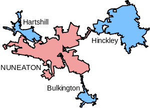
Map of the Nuneaton Urban Area.

The Nuneaton Urban Area is a conurbation in the West Midlands of England, based around the town of Nuneaton in Warwickshire. It had a population of 132,236 at the 2001 Census.

The conurbation consists of the large towns of Nuneaton and Hinckley, as well as the smaller villages of Hartshill and Bulkington. The majority of the area lies within Warwickshire, however, Hinckley is in Leicestershire and part of the East Midlands.

It is very close to and almost forms a continuous conurbation with the Coventry/Bedworth Urban Area.

Urban Subdivision Population
Nuneaton 70,721
Hinckley 43,246
Hartshill 12,207
Bulkington 6,062
Total Urban Area 132,236

References

Coordinates: 52°32′N 1°25′W / 52.53°N 1.41°W / 52.53; -1.41


Wikimedia Foundation. 2010.

Игры ⚽ Нужно решить контрольную?

Look at other dictionaries:

  • Coventry and Bedworth Urban Area — Map of the Coventry/Bedworth Urban Area. The Coventry/Bedworth Urban Area has a population of 336,452 making it the 20th largest conurbation in the United Kingdom and the 17th largest in England by population. It is also one of the most densely… …   Wikipedia

  • Nuneaton — Coordinates: 52°31′23″N 1°28′06″W / 52.523°N 1.4683°W / 52.523; 1.4683 …   Wikipedia

  • Nuneaton and Bedworth —   Borough, Non metropolitan district   Shown within Warwickshire Sovereign state …   Wikipedia

  • Urban rail in the United Kingdom — Urban rail, commuter rail, regional rail, or suburban rail, plays a key role in the public transport system of many of the United Kingdom s major cities. Urban rail is defined as a rail service between a central business district and suburbs or… …   Wikipedia

  • Coventry — For other uses, see Coventry (disambiguation). City of Coventry   City Metropolitan borough   …   Wikipedia

  • Hinckley — Infobox UK place country = England official name= Hinckley latitude= 52.54138 longitude= 1.372534 map type= Leicestershire civil parish= population = 43,246 (2001) shire district= Hinckley and Bosworth shire county= Leicestershire region= East… …   Wikipedia

  • Birmingham — This article is about the city in England. For the U.S. city named after it, see Birmingham, Alabama. For other uses, see Birmingham (disambiguation). City of Birmingham   City and Metropolitan borough   …   Wikipedia

  • Wolverhampton —   City   City of Wolverhampton …   Wikipedia

  • Constituency results of the United Kingdom general election, 2005 — Results of the United Kingdom general election, 2005. Contents 1 Scotland 1.1 Highlands and Islands 1.2 North East Scotland 1.3 Mid Scotland and Fife …   Wikipedia

  • Leicester — For other places with the same name, see Leicester (disambiguation). Coordinates: 52°38′03″N 1°08′19″W / 52.63422°N 1.13852°W / …   Wikipedia

Share the article and excerpts

Direct link
Do a right-click on the link above
and select “Copy Link”