- Norwegian County Road 889
-
889
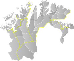
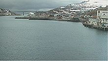
Route information Length: 85.3 km (53.0 mi) Major junctions South end: E69 at Smørfjord North end: Havøysund Location Counties: Finnmark Major cities: Havøysund Highway system County Road 889 (Norwegian: Fylkesvei 889) is 85.3 kilometers (53.0 mi) long and runs between Smørfjord and Havøysund in Finnmark, Norway. The road runs through Porsanger, Kvalsund and Måsøy. At Smørfjord, the road branches from E69. It crosses to Havøysund across the Havøysund Bridge. The section from Russelv to Havøysund is designated one of eighteen National Tourist Routes in Norway.[1][2]
 A section of the road in Måsøy
References
- ^ "Nasjonal turistveg Havøysund" (in Norwegian). Norwegian Public Roads Administration. Archived from the original on 5 October 2011. http://www.vegvesen.no/Vegprosjekter/havoysund/Om+strekningen. Retrieved 5 October 2011.
- ^ "Havøysund". Norwegian Public Roads Administration. Archived from the original on 5 October 2011. http://www.turistveg.no/en/havoysund#desc. Retrieved 5 October 2011.
National Tourist Routes in Norway Andøya (974 · 976 · 82) · Atlantic Ocean Road (64 · 242 · 663 · 235 · 238) · Aurlandsfjellet · Gamle Strynefjellsvegen · Gaularfjellet · Geiranger–Trollstigen · Hardanger (7 · 550 · 13) · Havøysund · Helgeland Coast · Jæren (44, 507) · Lofoten · Rondane · Ryfylke (13 · 46 · 520) · Senja (86 · 862) · Sognefjellsvegen · Valdresflye · Varanger (E75 · 341) Categories:
- Norwegian county roads
- Former Norwegian national roads
- National Tourist Routes in Norway
- Roads in Finnmark
- Porsanger
- Kvalsund
- Måsøy
- Norway road stubs
Wikimedia Foundation. 2010.


