- Nizhnekamsk Hydroelectric Station
-
Nizhnekamsk Dam 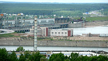
The hydroelectric power plantLocation of Nizhnekamsk Dam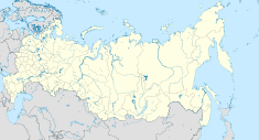

Official name Nizhnekamsk Hydroelectric Plant Country Russia Location Naberezhnye Chelny, Tatarstan Coordinates 55°41′58″N 52°16′42″E / 55.69944°N 52.27833°ECoordinates: 55°41′58″N 52°16′42″E / 55.69944°N 52.27833°E Status In use Construction began 1963 Dam and spillways Height 30 m (98 ft) Length 3,900 m (12,795 ft) Impounds Kama River Reservoir Creates Nizhnekamsk Reservoir Capacity 2,800,000,000 m3 (2,269,997 acre·ft) Surface area 1,084 km2 (419 sq mi) Power station Owner(s) Tatenergo Commission date 1979-1987 Hydraulic head 12.4 m (41 ft) Turbines 16 x 78 MW Kaplan turbines Installed capacity 1,248 MW Annual generation 2.54 billion kWh The Nizhnekamsk Hydroelectric Station (Russian: Нижнекамская ГЭС), also known as Lower Kama, is a dam and hydroelectric power station on the lower Kama River near Naberezhnye Chelny in Tatarstan, Russia. The purpose of the dam is power production, navigation and water supply. It powers a 1,248 MW station with 16 x 78 MW Kaplan turbine-generators.[1]
See also
- Votkinsk Hydroelectric Station
References
- ^ "Construction of the Lower Kama hydroelectric station". Power Technology and Engineering (formerly Hydrotechnical Construction). December, 1978. pp. 8–12. http://www.springerlink.com/content/rt1703w5rmg52537/. Retrieved 14 January 2011.
Categories:- Hydroelectric power stations built in the Soviet Union
- Hydroelectric power stations in Russia
- Dams in Russia


Wikimedia Foundation. 2010.