- Nive River (Queensland)
-
Nive River 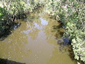
The Nive River near Augathella.Origin Queensland Mouth confluence with the Warrego River, Queensland Basin countries Australia Length 263 kilometres Source elevation 565 metres The Nive River is a river in the north-eastern Australian state of Queensland. It rises on the western slopes of Mount Playfair south of the Salvador Rosa section of Carnarvon National Park and flows westwards through Long Waterhole to approximately 15 km east of Tambo. There the Nive River flows to the south, following the Landsborough Highway before crossing it near Nive Downs. The river flows to the west of Augathella and has its confluence with the Warrego River south of Augathella.
From here the towns of Charleville, Wyandra and Cunnamulla are located on the banks of the Warrego River. Cunnamulla is the only town with a levee bank to protect it against flooding.[1] The Warrego River reaches the Darling River about 34 kilometres (21 mi) east of Louth.[2]
History
In 1845 Major Sir Thomas Mitchell was the first European to explore the Warrego River, and he named its tributary, the Nive River.[3] When the Mitchell district was opened for settlement the Bell and Dutton families were among the first applicants for land on the Nive River and their leases included the site of Tambo.[4]
See also
References
- ^ "Flood Warning System for the Warrego River". Bureau of Meteorology (Australia). http://www.bom.gov.au/hydro/flood/qld/brochures/warrego/warrego.shtml. Retrieved 2009-07-10.
- ^ Chisholm (ed.), Alec H. (1963). The Australian Encyclopaedia. Sydney, NSW: The Grolier Society of Australia. pp. 165 - Vol. 9.
- ^ Freemantle, Hayley. "27°S 146°E Yanna – Queensland by Degrees". Royal Geographical Society of Queensland. http://www.rgsq.org.au/27-146c. Retrieved 5 July 2011.
- ^ Kingston, Beverley. "Dutton, Charles Boydell (1834–1904)". Australian Dictionary of Biography. National Centre of Biography, Australian National University. http://adb.anu.edu.au/biography/dutton-charles-boydell-3459. Retrieved 5 July 2011.
Categories:- Rivers of Queensland
- Tributaries of the Darling River

Wikimedia Foundation. 2010.