- Ngame, Burma
-
Ngame — town — Location in Burma
 Ngame
NgameCoordinates: 21°04′54″N 92°58′12″E / 21.08167°N 92.97°ECoordinates: 21°04′54″N 92°58′12″E / 21.08167°N 92.97°E Country  Burma
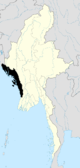
BurmaDivision Rakhine State District Sittwe District Township Kyauktaw Township Elevation 187 ft (57 m) Time zone MST (UTC+6.30) Ngame is a town in Kyauktaw Township, Sittwe District, in the Rakhine State[1] of western Burma, located on the right bank of the Kaladan River,[2] just south of the border with Chin State.
Notes
- ^ "Ngame (BGN Standard), Burma, Rakhine" Geonames
- ^ "Cox's Bazar, Pakistan; Burma; India: NF-46-10" U.S. Army Map Service topographic map 1:250,000, 1954, first printing March 1960
External links
- "Ngame Map — Satellite Images of Ngame", Maplandia.com
Rakhine State Capital: SittweSittwe District 
Maungdaw District Kyaukpyu District Thandwe District Main cities and towns Categories:- Populated places in Rakhine State
- Burma geography stubs


Wikimedia Foundation. 2010.