Maungdaw

Maungdaw

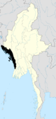
Maungdaw (Burmese: မောင်းတောမြို့, pronounced [máuɴdɔ́ mjo̰]) is a town in the Rakhine State of westernmost part of Myanmar. It it the administrative seat of Maungdaw Township and Maungdaw District.

Since September 1995, border trade between Maungdaw of Myanmar and Teknaf of Bangladesh is formally established.[1]

Landmark:
Maungdaw is the west most city of Burma and it is a border city too with Bangladesh separated by Naf river.
Tunnel which was built in 1918 on Maungdaw Buthidaung motor way.
Maungdaw is one of most populated cities where Rohingya people lives.
State High School Maungdaw is one of the best schools in Arakan.
Maungdaw is 16 miles away from Buthidaung which is situated on Mayu river.


References


External links

Coordinates: 20°49′N 92°22′E / 20.817°N 92.367°E / 20.817; 92.367


Wikimedia Foundation. 2010.

Игры ⚽ Нужно решить контрольную?

Look at other dictionaries:

  • Maungdaw Township — မောင်းတောမြို့နယ်   Township   Country …   Wikipedia

  • Maungdaw District — (Burmese: မောင်တောခရိုင်) is a district of the Rakhine State in western Myanmar. The population density is about 295 persons per square kilometer.[1] The capital lies at Sittwe Townships The district contains the following townships: Maungdaw… …   Wikipedia

  • Maungdaw District — Admin ASC 2 Code Orig. name Maungdaw District Country and Admin Code MM.01.8238605 MM …   World countries Adminstrative division ASC I-II

  • Ram Chet Chaudhary — is an Indian agricultural scientist.[1][2] Born and educated in India, he taught in various agricultural universities in India and went on to study in Germany. His works on agriculture have been published across the world and form part of the… …   Wikipedia

  • Rakhine State — ရခိုင်ပြည်နယ် Arakan State   State   Myanma transcription(s) …   Wikipedia

  • Rohingya villages — Villages inhabited by the Rohingya people of Myanmar (Burma).Akyab township*Santouli *Zailla fara *Folthon (Plok Taung) *Bodor Muham *Amla fara *Mouloi fara *Hocái fara *Nazir fara *Joltahán fara *Buhá fara *Kongsi(Hoñsi) fara *Ruáinggá(Rohingya) …   Wikipedia

  • Districts of Burma — Burma s states and regions are divided into 67 districts (Burmese: ခရိုင်; Burmese pronunciation: [kʰəjàiɴ]), which in turn are subdivided into townships then towns, wards and villages. Contents 1 List of districts by state or region …   Wikipedia

  • No. 5 Commando — Active 1940–1946 Country United Kingdom Branch …   Wikipedia

  • Battle of the Admin Box — Part of the Burma Campaign Sikh troops of 7th Indian Division man an observation post in the Ngakyedauk Pass area of the Arakan, Burma …   Wikipedia

  • Mrauk U — မြောက်‌ဦးမြို့ Mrauk U from Shwetaung pagoda …   Wikipedia

Share the article and excerpts

Direct link
Do a right-click on the link above
and select “Copy Link”