- Nakhchivan Airport
-
Nakhchivan International Airport
Naxçıvan Hava Limanı
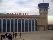
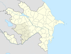
Airside view of terminal at Nakhchivan IATA: NAJ – ICAO: UBBN Location of airport in Azerbaijan Summary Airport type Public / Military Location Nakhchivan, Azerbaijan Elevation AMSL 2,863 ft / 873 m Coordinates 39°11′19″N 045°27′30″E / 39.18861°N 45.45833°E Runways Direction Length Surface m ft 14R/32L 3,300 10,826 Concrete 14L/32R 3,300 10,826 Asphalt Source: DAFIF[1][2] Nakhchivan Airport (Azerbaijani: Naxçıvan Hava Limanı) (IATA: NAJ, ICAO: UBBN) is a civilian airport and Azeri military airbase located in Nakhchivan[1], the capital of the Nakhchivan Autonomous Republic, a landlocked exclave of Azerbaijan.
Contents
Facilities
The airport resides at an elevation of 2,863 feet (873 m) above mean sea level. It has two runways: 14R/32L with a concrete surface measuring 3,300 by 45 metres (10,827 × 148 ft) and 14L/32R with an asphalt surface measuring 3,300 by 42 metres (10,827 × 138 ft).
Airlines and destinations
Airlines Destinations Azerbaijan Airlines Baku, Ganja RusLine Moscow-Domodedovo Turkish Airlines operated by AnadoluJet Seasonal: Istanbul-Sabiha Gökçen, Ankara Esenboga UTair Aviation Moscow-Domodedovo, Moscow-Vnukovo References
- ^ a b Airport information for UBBN from DAFIF (effective October 2006)
- ^ Airport information for NAJ at Great Circle Mapper. Source: DAFIF (effective Oct. 2006).
- (Russian) Polyot-Sirena Flight schedule
External links
 Airports in Azerbaijan
 Ağstafa • Baku • Balakən • Gabala • Ganja • Khojaly • Lankaran • Nakhchivan • Stepanakert • Yevlakh • Zaqatala
 Categories:
- Airports in Azerbaijan
- Azerbaijani Air Force bases
- European airport stubs
- Azerbaijani building and structure stubs
Wikimedia Foundation. 2010.


