- Mule Creek, New Mexico
-
Mule Creek, New Mexico — Unincorporated community — 
 Mule Creek, New Mexico
Coordinates: 33°07′19″N 108°57′22″W / 33.12194°N 108.95611°WCoordinates: 33°07′19″N 108°57′22″W / 33.12194°N 108.95611°W Country United States State New Mexico County Grant Elevation 5,233 ft (1,595 m) Time zone Mountain (MST) (UTC-7) – Summer (DST) MDT (UTC-6) ZIP code 88051 Area code(s) 575 GNIS feature ID 908973[1] Mule Creek is an unincorporated community in Grant County, New Mexico, United States. Mule Creek is located on New Mexico State Road 78 46 miles (74 km) northwest of Silver City. Mule Creek has a post office with ZIP code 88051.[2]
References
Municipalities and communities of Grant County, New Mexico City 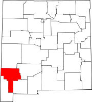
Towns Village Unincorporated
communitiesGhost towns Carpenter | Santa Rita | Tyrone
Categories:- Populated places in Grant County, New Mexico
- Unincorporated communities in New Mexico
- New Mexico geography stubs


Wikimedia Foundation. 2010.