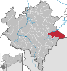
- Muldenhammer
-
Muldenhammer 
Coordinates 50°26′0″N 12°28′0″E / 50.433333°N 12.466667°ECoordinates: 50°26′0″N 12°28′0″E / 50.433333°N 12.466667°E Administration Country Germany State Saxony Admin. region Chemnitz District Vogtlandkreis Basic statistics Area 56.1 km2 (21.7 sq mi) Elevation 615-750 m Population 3,462 (31 December 2010)[1] - Density 62 /km2 (160 /sq mi) Other information Time zone CET/CEST (UTC+1/+2) Licence plate V Postal code 08262 Area code 037465 Muldenhammer is a municipality in the Vogtlandkreis district, in Saxony, Germany. It was formed by the merger of the previously independent municipalities Hammerbrücke, Morgenröthe-Rautenkranz and Tannenbergsthal, on 1 October 2009.
Adorf | Auerbach | Bad Brambach | Bad Elster | Bergen | Bösenbrunn | Eichigt | Ellefeld | Elsterberg | Erlbach | Falkenstein | Grünbach | Heinsdorfergrund | Klingenthal | Lengenfeld | Limbach | Markneukirchen | Mühlental | Mühltroff | Muldenhammer | Mylau | Netzschkau | Neuensalz | Neumark | Neustadt | Oelsnitz | Pausa | Plauen | Pöhl | Reichenbach im Vogtland | Reuth | Rodewisch | Rosenbach | Schöneck | Steinberg | Theuma | Tirpersdorf | Treuen | Triebel | Weischlitz | Werda | Zwota
References
- ^ "Bevölkerung des Freistaates Sachsen jeweils am Monatsende ausgewählter Berichtsmonate nach Gemeinden" (in German). Statistisches Landesamt des Freistaates Sachsen. 31 December 2010. http://www.statistik.sachsen.de/download/010_GB-Bev/Bev_Gemeinde.pdf.
Categories:- Municipalities in Saxony
- Saxony geography stubs
Wikimedia Foundation. 2010.


