- Mueang Phang Nga District
-
Mueang Phang Nga
เมืองพังงา— Amphoe — Amphoe location in Phang Nga Province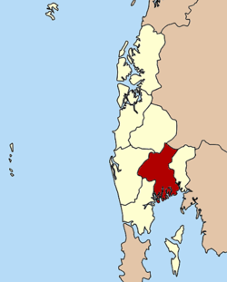
Coordinates: 8°26′36″N 98°31′5″E / 8.44333°N 98.51806°ECoordinates: 8°26′36″N 98°31′5″E / 8.44333°N 98.51806°E Country  Thailand
Province Phang Nga Seat Tambon Muban Amphoe established Area - Total 549.552 km2 (212.2 sq mi) Population (2005) - Total 38,426 - Density 69.9/km2 (181/sq mi) Time zone THA (UTC+7) Postal code 82000 Geocode 8201 Mueang Phang Nga is the capital district (amphoe mueang) of Phang Nga Province in southern Thailand.
Contents
Geography
Neighboring districts are (from the east clockwise) Thap Put, Phanom of Surat Thani Province, Kapong, Thai Mueang and Takua Thung. To the south is the Phang Nga bay, with the insular district Ko Yao.
The Ao Phang Nga National Park covers the islands south of the district. Sa Nang Manora Forest Park protects 0.29 km² of the Khao Toy Nang Hong Forest around the Sa Nang Manora waterfall. The Tonpariwat Wildlife Sanctuary in the north of the district is under construction. There are also several caves within the limestone hills.
Administration
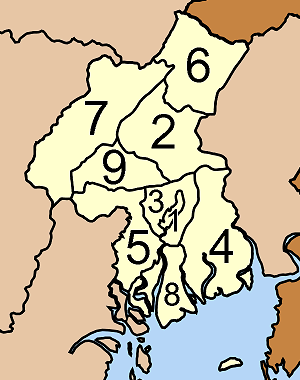
The district is subdivided into 9 subdistricts (tambon), which are further subdivided into 42 villages (muban). Phang Nga itself is a town (thesaban mueang) and covers the tambon Thai Chang. There are further 7 tambon administrative organizations (TAO).
No. Name Thai name Villages Inh. 1. Thai Chang ท้ายช้าง - 9559 2. Nop Pring นบปริง 8 6184 3. Tham Nam Phut ถ้ำน้ำผุด 4 3218 4. Bang Toei บางเตย 9 6667 5. Tak Daet ตากแดด 4 2886 6. Song Phraek สองแพรก 3 555 7. Thung Kha Ngok ทุ่งคาโงก 5 2535 8. Ko Panyi เกาะปันหยี 4 4218 9. Pa Ko ป่ากอ 5 2604 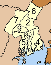
See also
External links
Categories:- Amphoe of Phang Nga

Wikimedia Foundation. 2010.