- Mueang Nonthaburi District
-
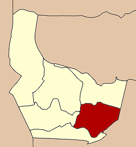
Mueang Nonthaburi
เมืองนนทบุรี— Amphoe — Amphoe location in Nonthaburi Province
Coordinates: 13°51′44″N 100°30′48″E / 13.86222°N 100.51333°ECoordinates: 13°51′44″N 100°30′48″E / 13.86222°N 100.51333°E Country  Thailand
Province Nonthaburi Seat Bang Kraso Tambon 10 Muban 26 (administrative) Amphoe established Area - Total 77.01 km2 (29.7 sq mi) Population (2008) - Total 353,923 - Density 4,591.33/km2 (11,891.5/sq mi) Time zone THA (UTC+7) Postal code 11000 Geocode 1201 Mueang Nonthaburi (Thai: เมืองนนทบุรี; IPA: [mɯ̄aŋ nōntʰáʔbūrīː]) is the capital district (amphoe mueang) of Nonthaburi province in Thailand. The city of Nonthaburi has 267,001 inhabitants, while the whole district has 348,553.
Contents
History
The district was originally named Talat Khwan. Simon de la Loubère, who was a French envoy extraordinary to the king of Ayutthaya, wrote in his book about Talat Khwan (Talacoan) as a principle place of the Chaophraya river side.[1] However it is unknown what year it was established. In 1917 the provincial administration of Nonthaburi was moved into the district, and thus the district was renamed to Mueang Nonthaburi. From January 1 1943 till May 9 1946 the province Nonthaburi was abolished and split between Thonburi and Phra Nakhon province, thus the district, which was then under Phra Nakhon province, was renamed to simply Nonthaburi.[2] After the recreation of the province it changed back to be Mueang Nonthaburi.[3]
Administration
The district is subdivided into 10 subdistricts (tambon), which are further subdivided into 77 villages (muban). The city (thesaban nakhon) of Nonthaburi covers the tambon Suan Yai, Talat Khwan, Bang Khen, Bang Kraso and Tha Sai. Bang Si Mueang has town status (thesaban mueang) and covers the tambon Bang Si Mueang and Bang Krang. Sai Ma has township status (thesaban tambon) and covers the same-named tambon.
No. Name Thai Inh. Villages 1. Suan Yai สวนใหญ่ 39,270 9 2. Talat Khwan ตลาดขวัญ 55,298 11 3. Bang Khen บางเขน 42,819 9 4. Bang Kraso บางกระสอ 55,574 9 5. Tha Sai ท่าทราย 73,827 7 6. Bang Phai บางไผ่ 8,027 5 7. Bang Si Mueang บางศรีเมือง 21,986 5 8. Bang Krang บางกร่าง 22,095 10 9. Sai Ma ไทรม้า 17,261 6 10. Bang Rak Noi บางรักน้อย 15,344 6 References
- ^ La Loubére, Simon de: A New Historical Relation of the Kingdom of Siam, London: 1693, p.4
- ^ "พระราชกฤษฎีกาเปลี่ยนชื่ออำเภอบางแห่ง พุทธศักราช ๒๔๘๖" (in Thai) (PDF). Royal Gazette 60 (3 ก): 103–105. January 12 1943. http://www.ratchakitcha.soc.go.th/DATA/PDF/2486/A/003/103.PDF.
- ^ "พระราชกฤษฎีกาเปลี่ยนชื่ออำเภอบางแห่ง พ.ศ. ๒๔๘๙" (in Thai) (PDF). Royal Gazette 63 (63 ก): 486–488. September 28 1946. http://www.ratchakitcha.soc.go.th/DATA/PDF/2489/A/063/486.PDF.
External links
Nonthaburi Main article 
Capital Districts (amphoe) Related topics Muang Thong Thani · IMPACT · Sukhothai Thammathirat Open University · The Mall Ngamwongwan · Ko Kret · International School Bangkok · Pakkred Secondary School · TOT FC · Bang Kwang Central Prison · Thailand Route 302 · Software Park
Neighboring areas Provinces: Ayutthaya · Pathum Thani · Nakhon Pathom
Bangkok: Don Mueang · Lak Si · Bang Sue · Bang Phlat · Taling Chan · Thawi WatthanaCategories:- Amphoe of Nonthaburi
- Central Thailand geography stubs
Wikimedia Foundation. 2010.