- Mount Washington Transit Tunnel
-
Mount Washington Transit Tunnel 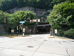
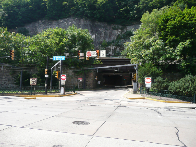
North portal to the tunnel Overview Location Pittsburgh, Pennsylvania, U.S.A. Status operational System Pittsburgh Light Rail Start Station Square End South Hills Junction Operation Work begun October 6, 1902 Opened December 1, 1904 Operator Port Authority of Allegheny County Technical Length 3,500 feet (1,100 m)[1] No. of tracks 2 Gauge 5 ft 2 1⁄2 in (1,588 mm) Electrified 1909 Grade 6% Mount Washington Transit Tunnel is an important public transportation link in Pittsburgh, Pennsylvania, United States. The approximately 3,500-foot (1,100 m)[1] tunnel connects Station Square to South Hills Junction, and is used only by Pittsburgh Light Rail cars and buses of the Port Authority of Allegheny County.
Contents
History
The tunnel was built by Booth and Flinn, as a replacement for the Pittsburgh and Castle Shannon Tunnel, but at a lower elevation. Excavation was started October 6, 1902, and the tunnel was officially opened December 1, 1904, for use by trolleys/streetcars only. Originally, steam powered trains ran through the tunnel, to be replaced by the first electric cars in 1909. It took over the transportation functions of the Castle Shannon Railway tunnel, which was originally a coal mine, but later used as a tunnel to transport coal,[2] and later passengers, under Mt. Washington. Although this tunnel was closed to passengers in 1880,[3] the urban legend persists that the Mt. Washington Transit Tunnel was originally a coal mine.
The tunnel was upgraded to allow for joint use by bus and trolley traffic in 1973, with several changes since.
Accidents
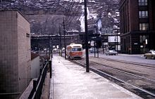 Northern exit of tunnel in 1968 showing site of both accidents
Two spectacular runaway accidents are associated with the tunnel, which is on a steep gradient averaging over 6 percent, and curves as the north portal is reached.
On December 24, 1917, Knoxville service car 4236 ran away downhill after becoming detached from the wire and derailed and overturned on the curve into Carson Street.[4] The car slid on its side until hitting a telegraph pole which ripped the roof off. Twenty-one people were killed and 80 were injured; the claims from the accident sent Pittsburgh Railways into receivership.[5]
On October 29, 1987, a 1700-series all-electric PCC car began to exceed the tunnel's speed limit as it entered the south portal after departing South Hills Junction. The operator, realizing the car could neither stop nor take the sharp curve from the transitway to the Panhandle Bridge ramp, ordered all the passengers to move to the back, and radioed the PAT central dispatcher to clear Station Square. The car left the rails and took Smithfield Street instead (the trolleys' original route downtown, until 1985), crossing Carson Street, sideswiping a PAT bus and a truck, and knocking out a fire hydrant. Miraculously, the car stayed on its wheels, and finally stopped next to the Pittsburgh History & Landmarks Foundation, the former Pittsburgh and Lake Erie station building at Station Square. Thirty-seven people were injured, four seriously, but there were no fatalities. All three braking systems on the car had failed: the drum, dynamic, and magnetic rail brakes.[6] Most of the 1700 series cars were found to have electrical defects, prompting PAT to retire all of their remaining PCC's that had not been rebuilt as 4000 series cars. Consequently, PAT was left with a shortage of cars, which contributed to the closure of the Overbrook line in 1993.[7]
References
- ^ a b Middleton, William D. (1967). The Time of the Trolley, p. 195. Milwaukee, WI (US): Kalmbach Publishing Co. LCCN 67-20155.
- ^ Chance, Henry Martyn (1884). Report of Progress.... pp. 179–180. http://books.google.com/books?id=ip0MAAAAYAAJ&pg=PA180&dq=%22Castle+Shannon+Mine%22#PPA179,M1. Retrieved 2008-09-08.
- ^ Cridlebaugh, Bruce S.. "Mt. Washington Transit Tunnel". http://pghbridges.com/pittsburghW/0584-4475/mtwashingtonPAT_tun.htm. Retrieved 2008-11-02.
- ^ "14 Persons Killed Wild Dash of Runaway Car". The Toronto World. December 25, 1917. http://news.google.com/newspapers?id=j5oFAAAAIBAJ&sjid=lSkDAAAAIBAJ&dq=runaway%20tunnel&pg=1683%2C750998. Retrieved April 29, 2011.
- ^ Smith, Harold A. (1992). Touring Pittsburgh by Trolley. NY: Quadrant Press. pp. 4–5. ISBN 0-915276-48-8.
- ^ Associated Press (October 29, 1987). "Runaway Pittsburgh trolley injures 37". Los Angeles Times. http://articles.latimes.com/1987-10-29/news/mn-17346_1_pittsburgh-trolley. Retrieved 29 April 2011.
- ^ Dupuis, Roger II. "Pittsburgh Railways history (Page 6)". Pittsburgh Railways OnLine. http://www.angelfire.com/ny/tramstop/history6.html. Retrieved 29 April 2011.
External links
- 40°25′20″N 80°00′23″W / 40.4221°N 80.0063°W - Southern portal
- 40°25′54″N 80°00′16″W / 40.4317°N 80.0044°W - Northern portal
Tunnels and bridges in Pittsburgh Tunnels Allegheny River Tunnel · Armstrong Tunnel · Fort Pitt Tunnel · Liberty Tunnel · Mount Washington Transit Tunnel · Pittsburgh and Castle Shannon Tunnel · Pittsburgh & Steubenville Extension Railroad Tunnel · Schenley Tunnel · Squirrel Hill Tunnel · Wabash Tunnel

Bridges 16th Street Bridge · 30th Street Bridge · 31st Street Bridge · 33rd Street Railroad Bridge · 40th Street Bridge · Bloomfield Bridge · Birmingham Bridge · Fort Duquesne Bridge · Fort Pitt Bridge · Fort Wayne Railroad Bridge · George Westinghouse Bridge · Glenwood Bridge · Glenwood B&O Railroad Bridge · Highland Park Bridge · Homestead Grays Bridge · Hot Metal Bridge · Liberty Bridge · McKees Rocks Bridge · Panhandle Bridge · Panther Hollow Bridge · Schenley Bridge · Senator Robert D. Fleming Bridge · Smithfield Street Bridge · South Tenth Street Bridge · Three Sisters (Roberto Clemente Bridge, Andy Warhol Bridge, Rachel Carson Bridge) · Veterans Bridge · West End Bridge
Categories:- Bridges in Pittsburgh, Pennsylvania
- Transportation in Pittsburgh, Pennsylvania
- Railroad tunnels in Pennsylvania

Wikimedia Foundation. 2010.