- Mount Vernon Township, Jefferson County, Illinois
-
Mount Vernon Township — Township — Location in Jefferson County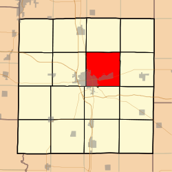 Jefferson County's location in Illinois
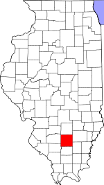
Coordinates: 38°20′55″N 88°51′34″W / 38.34861°N 88.85944°WCoordinates: 38°20′55″N 88°51′34″W / 38.34861°N 88.85944°W Country United States State Illinois County Jefferson Area - Total 37.27 sq mi (96.53 km2) - Land 36.98 sq mi (95.78 km2) - Water 0.29 sq mi (0.75 km2) 0.78% Elevation 528 ft (161 m) Population (2000) - Total 14,443 - Density 390.6/sq mi (150.8/km2) Time zone CST (UTC-6) - Summer (DST) CDT (UTC-5) ZIP codes 62864, 62872 GNIS feature ID 0429410 Mount Vernon Township is one of sixteen townships in Jefferson County, Illinois, USA. As of the 2000 census, its population was 14,443[1].
Contents
Geography
According to the United States Census Bureau, Mount Vernon Township covers an area of 37.27 square miles (96.5 km2); of this, 36.98 square miles (95.8 km2) (99.22 percent) is land and 0.29 square miles (0.75 km2) (0.78 percent) is water.
Cities, towns, villages
Unincorporated towns
- Camp Ground at 38°20′20″N 88°50′06″W / 38.3389378°N 88.8350617°W
- Idlewood at 38°22′49″N 88°55′22″W / 38.380327°N 88.9228419°W
- Summersville at 38°19′40″N 88°52′01″W / 38.3278269°N 88.8670074°W
(This list is based on USGS data and may include former settlements.)
Adjacent townships
- Field Township (north)
- Farrington Township (northeast)
- Webber Township (east)
- Pendleton Township (southeast)
- Dodds Township (south)
- Shiloh Township (west)
- Rome Township (northwest)
Cemeteries
The township contains these nine cemeteries: Atkinson, East Salem, Etheridge Farm, Hopewell, Oakwood, Old Union, Saint Mary's, Sursa and Williams.
Major highways
Airports and landing strips
- Good Samaritan Regional Health Care Center Heliport
- Mount Vernon/Outland Airport
Political districts
- Illinois' 19th congressional district
- State House District 107
- State Senate District 54
References
- "Mount Vernon Township, Jefferson County, Illinois". Geographic Names Information System, U.S. Geological Survey. http://geonames.usgs.gov/pls/gnispublic/f?p=gnispq:3:::NO::P3_FID:0429410. Retrieved 2010-01-17.
- United States Census Bureau 2007 TIGER/Line Shapefiles
- United States National Atlas
External links
Municipalities and communities of Jefferson County, Illinois County seat: Mount Vernon Cities Centralia‡ | Mount Vernon | Nason

Villages Belle Rive | Bluford | Bonnie | Dix | Ina | Waltonville | Woodlawn
Townships Bald Hill | Blissville | Casner | Dodds | Elk Prairie | Farrington | Field | Grand Prairie | McClellan | Moore's Prairie | Mt. Vernon | Pendleton | Rome | Shiloh | Spring Garden | Webber
Unincorporated
communitiesFootnotes ‡This populated place also has portions in an adjacent county or counties
Categories:- Townships in Jefferson County, Illinois
- Mount Vernon, Illinois micropolitan area


Wikimedia Foundation. 2010.