- Mount Tod
-
Mount Tod 
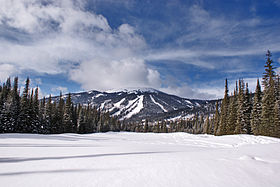
Mount Tod, looking Northwest.Elevation 2,155 m (7,070 ft) Prominence 1,523 m (4,997 ft) [1] Listing List of Ultras in Canada Location British Columbia, Canada Range Columbia Mountains Coordinates 50°55′0″N 119°56′27″W / 50.916667°N 119.94083°WCoordinates: 50°55′0″N 119°56′27″W / 50.916667°N 119.94083°W Mount Tod 2155 m (7070 ft), prominence: 1523 m,[2] commonly known as Tod Mountain, is a summit 50km northeast of Kamloops, British Columbia, Canada. Located northeast of the junction of Louis and McGillivray Creeks,[3] it is part of the upland area between the Interior Plateau (W) and the Monashee Mountains (E) known as the Shuswap Highland, the mountain is the highest of three summits comprising the Sun Peaks alpine ski resort.
Name origin
The mountain is named for John Tod, one of the most prominent of the fur traders assigned to the New Caledonia fur district. He first joined the Hudson's Bay Company in 1813.[4] He was in charge of Fort McLeod from 1823 to 1832, and in charge of Fort Kamloops (1841-43). His retirement home in British Columbia, on which he began instruction in 1850, is the oldest inhabited house in British Columbia.[5]
Also named for him is Tod Inlet, a sidewater of Saanich Inlet and formerly the name of a post office at that location, to the southwest of Brentwood Bay, and also Tod Creek, which flows into it, and Tod Rock, which is offshore.[6]
Mount Lolo, which is nearer to Kamloops than Mount Tod, is named for his right-hand man and interpreter, Jean Baptiste Lolo aka Chief Lolo, as is Paul Lake ("St. Paul" or "Chief Paul" were other names for Chief Lolo).
See also
- Tod (disambiguation)
References
- ^ "Mount Tod". Bivouac.com. http://www.bivouac.com/MtnPg.asp?MtnId=4107. Retrieved 2011-03-13.
- ^ Canadian Mountain Encyclopedia entry
- ^ "Tod, Mount". BC Geographical Names. http://apps.gov.bc.ca/pub/bcgnws/names/20917.html.
- ^ "Tod Inlet". BC Geographical Names. http://apps.gov.bc.ca/pub/bcgnws/names/20918.html.
- ^ Canadian Mountain Encyclopedia entry
- ^ "Tod Inlet". BC Geographical Names. http://apps.gov.bc.ca/pub/bcgnws/names/20918.html.
Categories:- British Columbia Interior geography stubs
- Mountains of British Columbia
- Kamloops
Wikimedia Foundation. 2010.

