- Mount Tamalpais and Muir Woods Railway
-
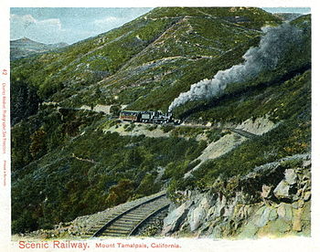 In this postcard image, one of the railroad's Shay locomotives works its way up Mount Tamalpais. Note the railroad's practice of pushing trains upgrade, with the engine reversed at the rear of the train.
The Mount Tamalpais & Muir Woods Railway was a scenic tourist railway operating between Mill Valley and the peak of Mount Tamalpais in Marin County, California, covering a distance of 8.19 miles (13.18 km), with a 2.5-mile (4.0 km) spur line through Muir Woods. The railroad began service in January 1896, closing only a little over three decades later, in the summer of 1930.[1] Although originally planned as a standard gauge electric trolley line, the railroad was powered by a succession of geared steam locomotives.[2] Billed as the "Crookedest Railroad in the World," the line was a popular diversion for many, renowned for its peculiarly steep and serpentine route, winding through picturesque terrain to a mountaintop tavern that provided striking views of the San Francisco Bay Area.[3] Despite its popularity, the railway met its ultimate demise following a devastating fire in 1929, accompanied by diminished ridership resulting from both increasing automobile competition and the Great Depression.[4]
Contents
Origin
Mount Tamalpais
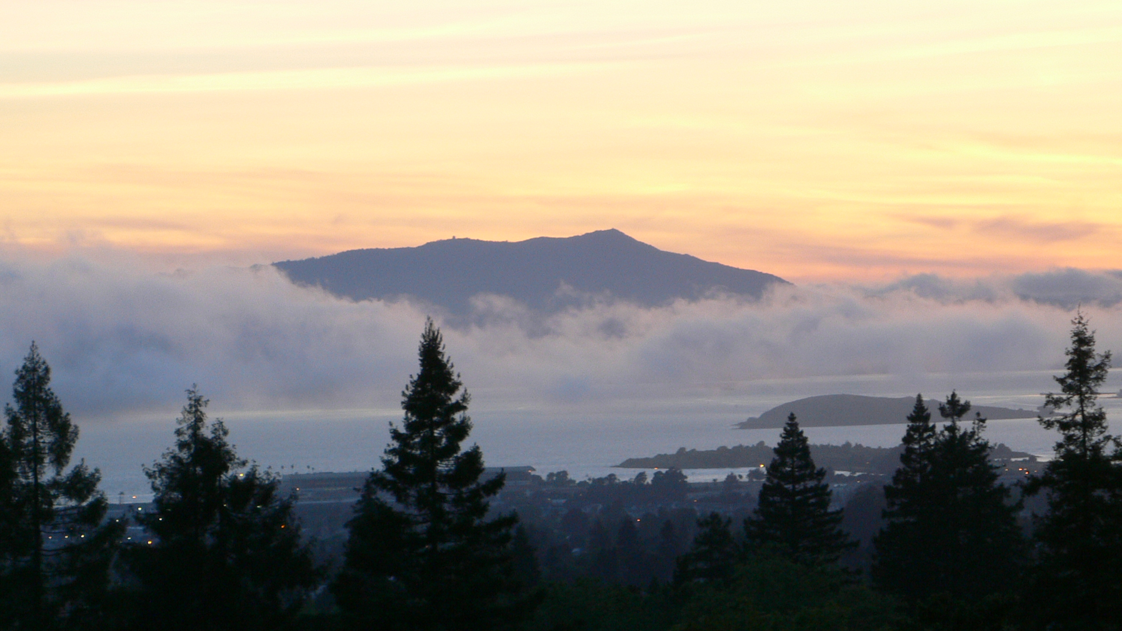
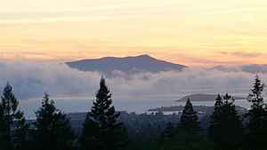 View of Mount Tamalpais at sundown.
The 2,600-foot[5] peak of Mount Tamalpais rises above redwood-shaded canyons and rugged grass-strewn hills only several miles from the shores of Stinson Beach. The area was initially overlooked by the first large-scale wave of American migrants to the region in the mid-19th century, most of whom quickly passed through coastal cities en route to inland gold fields during the California Gold Rush. By the late 19th century, however, most of the mineral deposits had dwindled and San Francisco had developed into a relatively large and dense urban center. During this same period, Marin County began to take on a much different identity in the region, from being regarded as a source of lumber to a place of remarkable natural beauty and appealing respite from the densely populated areas just south across the San Francisco Bay.
Mill Valley, located at the base of Mount Tamalpais, was first planned in the late 1880s and formally incorporated shortly after in 1900.[6] The city was named for a sawmill built by John Reed, to cut lumber harvested from the surrounding area. Once the area was logged, the land was divided into parcels and sold as home sites, which at first were primarily vacation residences. The city was served by The Sausalito Land and Ferry Company and the North Pacific Coast Railroad.[7] These provided access to Mill Valley, requiring a short ferry ride across the Bay from San Francisco to Sausalito, then a transfer to the railroad for another brief trip that terminated in Mill Valley. Mount Tamalpais lies only 12 miles (19 km) directly north of San Francisco and five miles (8 km) directly east of the Pacific Ocean.[8]
Due to ease of access provided by the ferry and rail service, entrepreneurs realized the potential for transforming the sleepy hills north of San Francisco into a recreational destination. Sidney B. Cushing was one such individual.[9] He had recently acquired the Blithedale Hotel summer resort just north of downtown Mill Valley in Corte Madera Canyon. The hills surrounding Mill Valley, however, were rather steep—requiring a dependable means of transportation for them to become an accessible vacation spot. Rail was the most logical means at the time, and Mount Tamalpais was the most attractive and unique destination for such a line.
Formation and construction of the railroad

Louis L. Janes was the initial impetus behind creating a railroad at Mount Tamalpais.[10] Janes was the resident director of the Tamalpais Land & Water Co. and first town clerk of Mill Valley.[11] Sidney B. Cushing, president of the San Rafael Gas & Electric Co., was chosen as President of the corporation.[12] It was initially named the Mill Valley and Mount Tamalpais Scenic Railway due to the fact the Muir Woods branch had not yet been planned. Funding came from several sources, provided to the corporation in exchange for stock in the company. One influential resident, A. E. Kent, gave the corporation right-of-way through his property in Corte Madera Canyon in exchange for $10,000 in stock.[9] A. E. Kent and his son, William, were early Mill Valley residents who foresaw the region's appeal to visitors from the Bay Area and beyond. William Kent was a Republican Congressman representing California from 1911–1917. Considering his family's financial interests in the railway, it is interesting to note that Kent spearheaded the movement to form the Muir Woods National Monument, a popular destination on the line.
Construction began on February 5, 1896. Originating at the North Pacific Coast Railroad depot in Mill Valley, the line was planned to ascend the surrounding hills to the summit of Mount Tamalpais, then over the top of the peak and down to Bolinas Beach. The pristine beach was difficult to access at the time and residents widely supported the line's planned arrival.[9] This, though, remained only a plan, as did the initial proposal to make the line an electric trolley route. A wagon road was constructed to Bolinas and electric power never supplanted the geared steam locomotives used to construct the line. Supplies and laborers arrived in Mill Valley and began work by February 1896. Over 200 men, largely Chinese laborers, graded the route and laid the rails. Many, though, left their jobs in protest due to poor pay and expensive board—$1.75 a day for 10 hours of work followed by a night at an obligatory boarding house costing $5.25 a week.[13] Despite these labor concerns and some local enmity from residents who opposed noisy locomotives running adjacent to their property, construction ensued. Within seven months, the railroad was completed at a cost of $5,000.[13] The last spike was driven on August 18, 1896, with the first passenger train operating just four days later.[14]
Operation
Route
The railroad's tracks originated from a depot located at 87 Throckmorton Avenue, at an elevation of approximately 70 feet (21 m). This building took several forms through the years, significantly more grandiose and Victorian than the current mission style depot occupied by a bookstore and cafe. Trains headed north through town, passing a water tank and shed at Lovell Avenue, and an engine house and shops on Corte Madera Avenue at Alcatraz Place. From the depot to King Street, the grade paralleled the Arroyo Corte Madera del Presidio stream that twists through Mill Valley between Blithedale and Corte Madera Avenues. Along the stream, the tracks continued north past the Blithedale Hotel until reaching Milepost One, at an elevation of 300 feet (91 m), approximately where Shady Lane crosses the stream today. At Lee Street the tracks passed a small station and water tank before continuing another 3/4 of a mile to Horse Shoe Curve, where the tracks crossed the stream one final time and headed southwest to Milepost Two. A siding was once located at Milepost Two, at an elevation of 400 feet (120 m). Continuing to head southwest, the tracks curved almost a dozen more times before reaching Milepost Three.
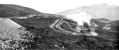 The "Double Bow Knot" curve, where tracks paralleled themselves five times in order to connect two points only 800 feet apart, but separated by a 130 foot climb in elevation.
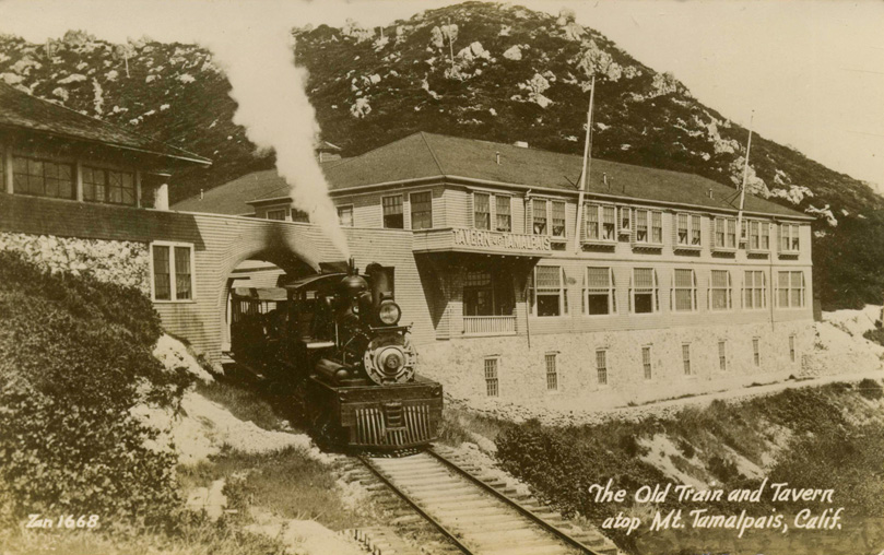
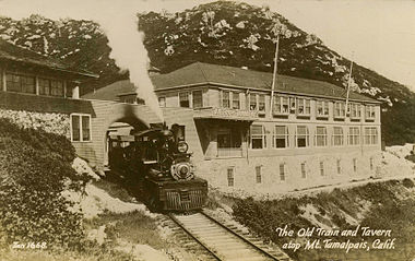 The Tamalpais Tavern was the northern terminus of the line. The structure provided a gathering place for railroad patrons, located a short walk from the peak of the mountain, which is visible in this photo directly above the structure.
At Milepost Three, the route reached an elevation of 700 feet (210 m). Fern Canyon Drive currently follows this section of the old roadbed, including a tight curve at Summit Avenue, followed by numerous curves until reaching Milepost Four, lying just beyond a large home currently located at the end of Fern Canyon Road. From Milepost Four, the roadbed loops around the home and becomes a fire road available to hikers who, from this point, can follow the roadbed to its terminus at the peak.
Mesa Junction was just beyond Milepost Four at an elevation of 1,000 feet (300 m), the starting point of the "Double Bow Knot" curve where the track paralleled itself four times to quickly gain elevation. Within this curve, the track passed another small depot, siding and water tank at a stop named Mesa Station. A siding branched off from mainline at Mesa Junction and headed southwest for Muir Woods, only known as Redwood Canyon when the extension was added in 1913.[15]
Just west of the Double Bow Knot, the tracks reached an elevation of 1,350 feet (410 m) at Milepost Five. Heisler locomotive No. 2 wrecked about 1/4 of a mile before Milepost Five on August 22, 1900, killing the engineer, Chester Thomas. Grease deposits on the rail caused the locomotive to jump the rails and topple down the slope on the south side of the tracks, damaging the locomotive and releasing steam that fatally scalded Chester Thomas.[16]
From this dubious point, the tracks then headed west past another water tank, reaching Milepost Six at an elevation of 1,730 feet (530 m), where Boot Jack Siding was located. After another half mile west, the tracks headed over Slide Gulch to West Point Inn, then curved back east for another half mile to Milepost Seven at an elevation of 2,060 feet (630 m). Milepost Eight was further east up the mountain at an elevation of 2,350 feet (720 m). From here, the tracks wound around a broad curve for just less than a 1/4 of a mile to the railroad's final destination, Tamalpais Tavern, at an elevation of 2,436 feet (742 m).
Curvature
The railroad ascended a particularly steep grade from its starting point at the North Pacific Coast depot in Mill Valley – at an elevation of approximately 70 feet (21 m) – to its destination at a tavern just below the summit of Mount Tamalpais – at an elevation of 2,436 feet (742 m). In order to follow a grade that steam locomotives could ascend, the track had to maintain a reasonable vertical climb. The entire line's average grade was 5%, comprising maximum grades of 7% at some points on the line. As the crow flies, the peak of Mount Tamalpais is only a few miles from Mill Valley. However, a direct approach presented an impracticably steep ascent for the railroad. Thus, it meandered 8.19 miles (13.18 km) up the mountain, cutting its way back and forth across the terrain. According to an article entitled "Geared Locomotives on the Mount Tamalpais Railway" from the July 16, 1898 edition of Scientific American, the mainline had only 3.282 miles (5.282 km) of straight track, with the remainder composed of the following 266 curves:[17]
- 26 curves of 70 feet (21 m) radius, [amounting to a total distance of] 3,641 feet (1,110 m)
- 24 curves of 80 feet (24 m) radius, 2,974 feet (906 m)
- 20 curves of 90 feet (27 m) radius, 2,328 feet (710 m)
- 49 curves of 100 feet (30 m) radius, 4,020 feet (1,230 m)
- 46 curves of 110 to 150 feet (46 m) radius, 4,403 feet (1,342 m)
- 59 curves of 150 to 300 feet (91 m) radius, 4,710 feet (1,440 m)
- 42 curves of 300 feet (91 m) radius and upward, 3,837 feet (1,170 m)
Steam locomotives
Road Number Builder Type Works Number Year Built Weight (lbs) Notes No. 498 Lima Locomotive Works 2-truck Shay locomotive #498 January 29, 1896 40,000 Built for Robert Dollar's Usal Lumber Company, but ran briefly prior to shipment from San Francisco as the first locomotive on the Mount Tamalpais railroad[18] No. 1 Lima Locomotive Works 2-truck Shay locomotive #597 March 13, 1900 Sold in 1904 for $2,250[19] to Deep River Logging Company of Washington[18] No. 2 Stearns Manufacturing Company 2-truck Heisler locomotive #1005 1896 60,000 The railroad's only fatal accident occurred when No. 2 derailed, breaking a steam line, fatally burning engineer Chester Thomas;[20] named the John G. Eastland but referred to as the Bull[21] No. 3 Stearns Manufacturing Company 2-truck Heisler locomotive 1898 60,000 Named the S.B. Cushing; returned to Stearns due to an unsatisfactory "cab arrangement," hence a replacement No. 3 listed below;[22] once pictured in Scientific American[23] No. 3 Lima Locomotive Works 2-truck Shay locomotive #646 April 25, 1901 46,000 Sold to the California & Oregon Power Co. of Hornbrook, CA, in September 1915; used for construction of Hetch Hetchy Reservoir in 1917; sold to Flora Logging Company of Carlton, Oregon in 1923; then to Union Lumber Company of Washington; scrapped October 10, 1929[18] No. 4 Lima Locomotive Works 2-truck Shay locomotive #832 August 5, 1903 46,000 Purchased for $6,900;[24] sold 1930; scrapped 1931[18] No. 5 Lima Locomotive Works 2-truck Shay locomotive #1666 June 22, 1906 Leased briefly for construction Hetch Hetchy Reservoir in 1917; sold and rebuilt in 1930; shipped 1937 for operation on Mindanao in the Philippines[18] No. 6 H. K. Porter, Inc. 0-4-0 tank #3483 1906 36,000 Sold in 1915 for $1,400; scrapped in 1944[24] No. 7 Lima Locomotive Works 2-truck Shay locomotive #1945 August 4, 1907 74,000 Sold in 1930 and shipped to the Philippines in 1934[18] No. 8 Lima Locomotive Works 2-truck Shay locomotive #2505 April 6, 1912 74,000 Sold in 1931 to Shell Oil for use at a refinery in Martinez, CA;[24] resold to Six Companies, Inc. of Boulder City, Nevada; wrecked and scrapped in 1932[18] No. 9 Heisler Locomotive Works 2-truck Heisler locomotive #1446 1920 72,000 Sold in 1924 for $9,750 to Siskiyou Lumber Co. of Macdoel, CA;[25] the only surviving engine from the railroad, on display in Scotia, CA[26] References
- ^ Wurm & Graves (1958)
- ^ Wurm & Graves (1958), p. 21.
- ^ Wurm & Graves (1958), p. 12.
- ^ Nayer, Alan. "City of Mill Valley : Mount Tamalpais". City of Mill Valley. http://www.cityofmillvalley.org/Index.aspx?page=653. Retrieved September 28, 2008.
- ^ Since construction of the railway, the top of the peak has been reduced to 2,574 feet, resulting from construction of a radar dome.
- ^ Nayer, Alan. "City of Mill Valley : History". City of Mill Valley. http://www.cityofmillvalley.org/Index.aspx?page=551. Retrieved March 21, 2009.
- ^ Wurm & Graves (1958), supra note 1, at 15.
- ^ Anonymous (1898), p. 39.
- ^ a b c Wurm & Graves (1958), supra note 1, at 14.
- ^ 'Wurm & Graves (1958), at 13
- ^ "Mill Valley Lodge History". http://mill-valley.freemasonry.biz/history/biographies.htm.
- ^ Skolnick (1989), p. 94.
- ^ a b Skolnick (1989), supra note 13, at 94 (which appears to misquote the cost per week for board, listed as $5.25 a week in Wurm & Graves (1958) at 16).
- ^ Wurm & Graves (1958), supra note 1, at 33.
- ^ Wurm & Graves (1958), at 75.
- ^ Wurm & Graves (1958), at 40.
- ^ Anonymous (1898), supra note 9.
- ^ a b c d e f g Koch (1971), pp. 398, 401, 404, 410, 419, 424 & 438.
- ^ Koch (1971) at 42.
- ^ Koch (1971) at 40.
- ^ Koch (1971) at 37.
- ^ Koch (1971) at 110
- ^ Koch (1971) at 41.
- ^ a b c Koch (1971)
- ^ Koch (1971) at 107.
- ^ "Surviving Steam Locomotives in California". SteamLocomotive.com. http://www.steamlocomotive.com/lists/searchdb.php?country=USA&state=CA. Retrieved November 14, 2011.
Bibliography
- Anonymous (1898). "Geared locomotives on the Mount Tamalpais Railway". Scientific American: 39.
- Koch, Michael (1971). The Shay Locomotive Titan of the Timber. The World Press.
- Skolnick, Sharon (1989). Dreams of Tamalpais. Last Gasp Publishing. ISBN 9780867193572.
- Wurm, Theodore G.; Graves, Alvin C. (1958). The Crookedest Railroad in the World: California's Mt. Tamalpais & Muir Woods Railroad. Howell-North Books.
Categories:- Defunct California railroads


Wikimedia Foundation. 2010.