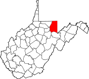
- Mount Olivet, Preston County, West Virginia
-
Mount Olivet, West Virginia — Unincorporated community — Coordinates: 39°20′19″N 79°37′13″W / 39.33861°N 79.62028°WCoordinates: 39°20′19″N 79°37′13″W / 39.33861°N 79.62028°W Country United States State West Virginia County Preston Elevation 2,612 ft (796 m) Time zone Eastern (EST) (UTC-5) – Summer (DST) EDT (UTC-4) Area code(s) 304 & 681 GNIS feature ID 1552213[1] Mount Olivet is an unincorporated community in Preston County, West Virginia, United States. Mount Olivet is 2.5 miles (4.0 km) east of Rowlesburg.
References
- ^ "US Board on Geographic Names". United States Geological Survey. 2007-10-25. http://geonames.usgs.gov. Retrieved 2008-01-31.
Municipalities and communities of Preston County, West Virginia City Towns Albright | Brandonville | Bruceton Mills | Masontown | Newburg | Reedsville | Rowlesburg | Terra Alta | Tunnelton
CDP Unincorporated
communitiesAfton | Alpine Lake | Amboy | Arthurdale | Borgman | Clifton Mills | Corinth | Denver | Eglon | Evansville | Fellowsville | Glade Farms | Hazelton | Hopemont | Hopewell | Horse Shoe Run | Howesville | Independence | Israel | Mount Nebo | Mount Olivet | Mountain View (north) | Mountain View (south) | Silver Lake
Categories:- Populated places in Preston County, West Virginia
- Unincorporated communities in West Virginia
- Mountaineer Country geography stubs
Wikimedia Foundation. 2010.


