- Mount Mills (California)
-
For other uses, see Mount Mills.
Mount Mills 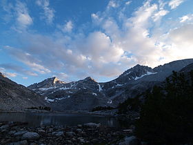
Mount Mills is the peak on the right, taken from southern end of Little Lakes ValleyElevation 13,451 ft (4,100 m) [1] Prominence 451 ft (137 m) [1] Location Location of Mount Mills in California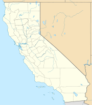
 Mount Mills
Location Fresno and Inyo counties, California, USA Range Sierra Nevada Coordinates 37°23′38″N 118°47′27″W / 37.3938241°N 118.7909546°WCoordinates: 37°23′38″N 118°47′27″W / 37.3938241°N 118.7909546°W[2] Topo map USGS Mount Abbot Mount Mills is a Thirteener and California 4000 meter peak on the Sierra Crest north of Mount Abbot and south of Mono Pass on the Inyo – Fresno county line. The Mono Recesses are to the west.
The summit is named in honor of Darius Ogden Mills, a banker and founder of the city of Millbrae, California and the Carson and Colorado Railroad. The name appeared on the first edition of the Mt Goddard topographic map in 1912.[3]
References
- ^ a b "Mount Mills, California". Peakbagger.com. http://www.peakbagger.com/peak.aspx?pid=2664. Retrieved 2010-10-07.
- ^ "Mount Mills". Geographic Names Information System, U.S. Geological Survey. http://geonames.usgs.gov/pls/gnispublic/f?p=gnispq:3:::NO::P3_FID:263654. Retrieved 2010-10-07.
- ^ Browning, Peter (1986). Place Names of the Sierra Nevada. Berkeley: Wilderness Press. p. 148. ISBN 978-0-89997-119-3.
Categories:- Mountains of Fresno County, California
- Mountains of Inyo County, California
- Mountains of the John Muir Wilderness
- California geography stubs


Wikimedia Foundation. 2010.