Moriac railway station

Moriac railway station
Moriac
Moriac4.jpg
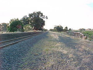
Station information
Line Warrnambool
Distance from Southern Cross 96.68 km (60.07 mi)
Number of platforms 2
Number of tracks 2
Station status Closed
Station closed 4 October 1981
Map of station G-Map Link

Moriac is a closed station located in the town of Moriac, on the Warrnambool railway line in Victoria, Australia. Remaining facilities include a bluestone platform, with a goods platform opposite. Moriac was made the junction of the short branch line south to Wensleydale in 1889, with the line closed in 1948.[1] The station was one of 35 closed to passenger traffic on 4 October 1981, as part of the New Deal timetable for country passengers.[2]

References

  1. ^ "Rail Geelong - Moriac Station". www.railgeelong.com. http://www.railgeelong.com/location/moriac. Retrieved 2008-11-02. 
  2. ^ Scott Martin and Chris Banger (October 2006). "'New Deal' for County Passengers - 25 years on". Newsrail (Australian Railway Historical Society (Victorian Division)): page 319. 

Coordinates: 38°14′24″S 144°10′23″E / 38.24°S 144.17306°E / -38.24; 144.17306


Wikimedia Foundation. 2010.

Игры ⚽ Поможем написать реферат

Look at other dictionaries:

  • Moriac railway station, Victoria — VictorianClosedRailwayStation NAME= Moriac LINE=Warrnambool DISTANCE=96.68 km PLATFORMS= 2 TRACKS= 2 STATUS=Closed OPENED= CLOSED=October 4, 1981 http://maps.google.com/maps?q= 37.899405,144.660807(Werribee+Railway+Station) ie=UTF8 om=1 z=18 ll=… …   Wikipedia

  • Moriac, Victoria — Moriac Victoria General store and railway crossing on the main street …   Wikipedia

  • List of localities in Victoria (Australia) — Map of Local Government Areas in Victoria This is a list of locality names and populated place names in the state of Victoria, Australia, outside the Melbourne metropolitan area. It is organised by region from the south west of the state to the… …   Wikipedia

  • Waurn Ponds, Victoria — Infobox Australian Place | type = suburb name = Waurn Ponds city = Geelong state = vic caption = View of the suburb south from Rossack Drive lga = City of Greater Geelong postcode = 3216 pop = 2326 (2006)Census 2006 AUS | id = SSC22141 | name =… …   Wikipedia

  • Geelong — This article is about the Victorian city; the name may also refer to City of Geelong or Geelong city centre. Geelong Victoria …   Wikipedia

  • Geelong, Victoria — Infobox Australian Place | type = city name = Geelong state = vic lga = City of Greater Geelong caption = Corner of Moorabool and Malop Streets, Geelong pop = 160,991 (2006) pop footnotes = Census 2006 AUS|id=2024|name=Geelong (VIC) (Statistical… …   Wikipedia

  • Electoral district of South Barwon — South Barwon is an electoral district of the Legislative Assembly in the Australian state of Victoria. Located in a mixed urban and rural area south of the Barwon River, it covers an area of 621km², including the Geelong suburbs of Belmont and… …   Wikipedia

Share the article and excerpts

Direct link
Do a right-click on the link above
and select “Copy Link”