- Monte Musinè
-
Monte Musinè 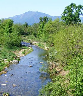
The mountain seen from Casternone (San Gillio)Elevation 1,150 m (3,773 ft) Prominence 202 m (663 ft)
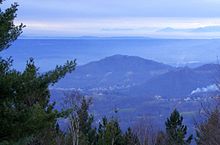
Italian official map 1:25.00 of Istituto Geografico Militare (on-line on www.pcn.minambiente.itLocation Location Italy Range Graian Alps Coordinates 45°06′50″N 7°27′16″E / 45.11389°N 7.45444°E Climbing Easiest route South-Eeast ridge from Caselette Monte Musinè or simply Musinè (also in Piedmontese Mont Musinè) is a mountain in the Graian Alps in Italy. Musinè is well known for its high cross on the top, and because it's the closest mountain to Turin; it can be seen from some distance, from the Piedmontese plateau or from the mountains in Biella's or Vercelli's provinces.
Contents
Geography
Mount Musinè is the easternmost mountain of the long ridge which, starting from Rocciamelone, divides the valleys of Susa and Lanzo.
Its main summit has a subsummit called Truc dell'Eremita (Hermit's hill, 1.101 m) and is surrounded by several minor hills: on an hill eastwards stands Saint Abaco's sanctuary (535 m) and on Monte Calvo (north-east, 551 m) there is a Via Crucis ending with a chapel.
The Musinè is linked from neighbouring Mount Curt (1.323 m) by a wide wooden ridge which lowest point is the Colle della Bassetta (Bassetta's pass, 945 m).
Musinè's top is the tripoint at which the borders of the municipalities of Caselette, Almese and Val della Torre meet.
History
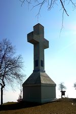 The cross on the summit
Several archaeological researches found prehistoric and protohistoryc records in the area. Among them traces of a hut dating the early bronze age (ca 1700 b.C.) in the municipality of Caselette.[1] and several finding of late Iron Age (last centuries b.C.) not faraway from Almese (Truc Randolera).[2]
Two roman buildings of the imperial age are located near the mountain: a villa rustica (in the municipality of Caselette) and a big residential villa in the municipality of Almese (Grange di Rivera).[3].
A local tradition states that near the Musinè (and not during the Battle of Milvian Bridge) emperor Constantine I would have seen a flaming cross and the In hoc signo vinces motto a little before the Campi Taurinati battle, which he won against his rival Maxentius.
A cross 15 metres high [4] was built in 1901 on the top of the mountain using reinforced concrete.[5]
On the north-eastern slopes of Musinè several magnesite quarries have been active between 1875 and the second world war.[6].
Nature conservation
The mountain and its surrounding area are included in a SIC (Site of Community Importance) of 1.524,29 ha called Monte Musine' e Laghi di Caselette (code IT1110081).[7]
References
- ^ A. Bertone et al., in "Quaderni della Soprintendenza Archeologica del Piemonte" 11 (1993), pp. 274-276
- ^ A. Bertone, in "Quad. Sopr. Arch. Piem." 3 (1984), pag.279-280
- ^ E. Lanza, G. Monzeglio, I Romani in valle di Susa, S. Ambrogio 2001, pp. 71-76 e 92-97; D. Vota, Duemila anni fa in Valle di Susa. Il tempo dei Cozii, Borgone 2010, pag. 190-195 and 207-210, with reference biography
- ^ Aldo Molino, Musiné Monte del mistero, article on Piemonte Parchi n.128 june/july 2003, pag.46-47
- ^ D. Vota, Il segno sul monte, Borgone 2001
- ^ D. Vota, La comunità civica nell'Ottocento, in Caselette. Uomini e ambienti cit., pp. 374-380
- ^ Siti di Importanza Comunitaria (SIC), Regione Piemonte, list on gis.csi.it (accessed in September 2011)
External links
Categories:- One-thousanders
- Mountains of Piedmont
- Mountains of the Alps
- Archaeological sites in Italy
- Province of Turin


Wikimedia Foundation. 2010.