- Montague railway station
-
Montague 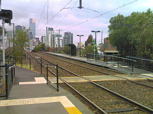
Montague light rail stop todayStation information Line Port Melbourne Distance from Southern Cross 1.6km Number of platforms 2 Number of tracks 2 Station status Closed Station opened June 2nd, 1883 Station closed December, 1987 Montague was a railway station, now converted to light rail, on the former Port Melbourne railway line in the inner Melbourne suburb of South Melbourne, Australia. The station was located to the south of Montague Street road underpass, between Woodgate Street and Gladstone Lane, with a large goods shed located on the Melbourne side of the station. The station has since been demolished and is now served by route 109 trams stopping at a pair of low level platforms.
History
Montague station opened in 1883, a number of years after the original opening of the line through it in 1854.[1] The station mainly served workers at nearby factories, so under a new timetable in May 1967 the station was closed on Sundays due to a lack of passengers. This was altered in June 1969 so that two late night trains would stop there, to cater for shift workers.[2]
In 1908 plans were first made to relocate the functions of the 1870s Shipping Shed at Spencer Street Station (roughly where platforms 9 and 10 are today) to a new location. A site to the north of the Port Melbourne line and on the Melbourne side of Montague station was selected, with work commencing in 1913.[3] A southerly deviation of the Port Melbourne line was made between Clarendon and Inglis Streets to make way for two 5 ton travelling jib cranes,[4] and Montague Street was extended northward under the tracks to compensate for the removal of the level crossing gates at Ferrars Street. Track work was underway in 1915 but was delayed by World War I, with the Shipping Shed not completed until late 1921.[3]
The Shipping Shed had a number of sidings inside, as well as more outside. Two goods lines ran to the north of the station, connecting the shipping shed yard with the main line near Inglis Street, where a signal box was located to control the points and signals.[5] The signal box at Inglis Street was abolished in October 1971 and replaced by a signal panel at Graham station down the line.[2][6]
The shed operated in conjunction with the H.M. Customs Department for the handling of freight that arrived by sea at Port Melbourne's Princes Pier. This continued for five decades, until containerisation saw the end of conventional cargo handling at Port Melbourne. In later years the shed was used to store rolls of newsprint from Australian Paper Manufacturers Maryvale Mill until the closure of the line.[3]
The last passenger train ran to the station on 10 October 1987 after it was announced that the line would be converted to light rail. The last goods train to Montague Yard ran on 16 October 1987 with a single Y class diesel locomotive.[7] The replacement light rail line was officially opened on December 18, 1987.[8]
In the early 1990s construction of the Melbourne Exhibition Centre covered the area once occupied by the Shipping Shed,[9] while the construction of Southbank tram depot and the diversion of Normanby Road towards Whiteman Street have obliterated all traces of the Shipping Shed yard.[3]
Gallery
-
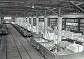
Interior of the Montague shipping shed from the internal footbridge
-

Exterior of the shipping shed
-

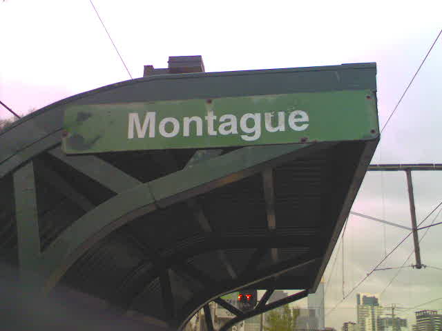
1980s-style railway station name plate for Montague, in the colours of the Metropolitan Transit Authority. Two plates remain, affixed to the approach sides of the waiting shelters
References
- ^ "Montague". VICSIG - Infrastructure. www.vicsig.net. http://www.vicsig.net/index.php?page=infrastructure&name=Montague. Retrieved 2008-07-05.
- ^ a b S.E. Dornan and R.G. Henderson (1979). Electric Railways of Victoria. Australian Electric Traction Society. ISBN 0 909459 06 1.
- ^ a b c d T. Penn and D. Jowett (September 2007). "Montague Goods Shed". Locolines. www.rtbuvicloco.com.au. http://www.rtbuvicloco.com.au/locolines/LL%203%2007.pdf. Retrieved 2008-07-05.
- ^ "Port Melbourne Flinders Street Railway Reservation, South Melbourne, VIC Profile". www.aussieheritage.com.au. http://www.aussieheritage.com.au/listings/vic/South%20Melbourne/PortMelbourneFlindersStreetRailwayReservation/17807. Retrieved 2008-07-05.
- ^ "Port Melbourne line: Flinders Street to Bridge Street 1941". Victorian Railways signalling diagram. www.signaldiagramsandphotos.com. http://www.signaldiagramsandphotos.com/mywebpages/vr/Metropolitan/1%2741.htm. Retrieved 2008-07-05.
- ^ "Port Melbourne line 1974". Victorian Railways signalling diagram. www.victorianrailways.net. http://www.victorianrailways.net/signaling/completedia/ptmelb1971.html. Retrieved 2008-07-05.
- ^ "Traffic". Newsrail (Australian Railway Historical Society (Victorian Division)): pages 20–22. January 1988.
- ^ Chris Banger (March 1997). "Rail Passenger Service Withdrawals Since 1960". Newsrail (Australian Railway Historical Society (Victorian Division)): pages 77–82.
- ^ "Melway Edition 1". www.custommaps.net. http://www.custommaps.net/images/mwyedn1.htm. Retrieved 2008-07-05. (see map 23)
Station navigation Port Melbourne line Sandridge Bridge | North Port Next station → Closed stations Coordinates: 37°49′49″S 144°56′55″E / 37.8303°S 144.9486°E
Categories:- Disused railway stations in Melbourne
- Railway stations opened in 1883
- Railway stations closed in 1987
-


Wikimedia Foundation. 2010.