- Mitchell Municipal Airport
-
Mitchell Municipal Airport 
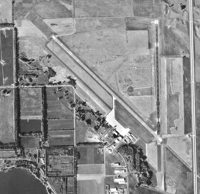
1997 USGS Photo IATA: MHE – ICAO: KMHE Summary Airport type Public Owner City of Mitchell Location Mitchell, South Dakota Elevation AMSL 1,304 ft / 397 m Coordinates 43°46′33″N 098°02′17″W / 43.77583°N 98.03806°WCoordinates: 43°46′33″N 098°02′17″W / 43.77583°N 98.03806°W Runways Direction Length Surface ft m 12/30 6,700 2,042 Asphalt 17/35 5,512 1,680 Asphalt 
 Mitchell MAPLocation of Mitchell Municipal Airport, South Dakota
- For the United States Air Force base located in New York, see Mitchel Air Force Base
Mitchell Municipal Airport (IATA: MHE, ICAO: KMHE, FAA LID: MHE) is a public airport located within city limits approximately 5 miles (8.0 km) north of central Mitchell, South Dakota.
Contents
History
Opened in November 1937, during World War II, the facility was rebuilt in 1943 by the United States Army Air Force as a Second Air Force B-17 Flying Fortress and B-24 Liberator heavy bomber training airfield field known as Mitchell Army Airfield.
On 1 October 1944, when training ended at the facility, it was transferred to Air Technical Service Command where it was assigned to Ogden Air Service Command as an axillary airfield.
Returned over to civil use after the war, it is now a public airport providing general aviation service.
See also
References
 This article incorporates public domain material from websites or documents of the Air Force Historical Research Agency.
- Shaw, Frederick J. (2004), Locating Air Force Base Sites History’s Legacy, Air Force History and Museums Program, United States Air Force, Washington DC, 2004.
External links
- Resources for this airport:
- AirNav airport information for KMHE
- ASN accident history for MHE
- FlightAware airport information and live flight tracker
- NOAA/NWS latest weather observations
- SkyVector aeronautical chart for KMHE
- FAA current MHE delay information
 USAAF Second Air Force in World War II
Airfields Group Training Stations · Heavy Bombardment Training Stations · Replacement Training Stations · Tactical Airfields · Very Heavy Bomber Bases
Units Commands II Air Support Command · II Bomber Command · II Fighter Command · IV Air Support Command · XX Bomber Command · XXI Bomber Command · XXII Bomber CommandWings 5th Bombardment · 15th Bombardment Training · 16th Bombardment Operational Training · 17th Bombardment Training · 18th Replacement · 21st Bombardment · 46th Bombardment Operational Training · 58th Bombardment · 73d Bombardment · 315th Bombardment · 316th BombardmentGroups Bombardment 2d Bombardment · 6th Bombardment · 7th Bombardment · 9th Bombardment · 12th Bombardment · 16th Bombardment · 17th Bombardment · 19th Bombardment · 25th Bombardment · 29th Bombardment · 34th Bombardment · 39th Bombardment · 40th Bombardment · 42d Bombardment · 46th Bombardment · 47th Bombardment · 48th Bombardment · 85th Bombardment · 86th Bombardment · 86th Bombardment · 88th Bombardment · 94th Bombardment · 95th Bombardment · 96th Bombardment · 99th Bombardment · 100th Bombardment · 301st Bombardment · 302d Bombardment · 303d Bombardment · 304th Bombardment · 305th Bombardment · 306th Bombardment · 307th Bombardment · 308th Bombardment · 312th Bombardment · 330th Bombardment · 331st Bombardment · 333d Bombardment · 346th Bombardment · 351st Bombardment · 376th Bombardment · 379th Bombardment · 381st Bombardment · 382d Bombardment · 383d Bombardment · 384th Bombardment · 385th Bombardment · 388th Bombardment · 390th Bombardment · 393d Bombardment · 395th Bombardment · 396th Bombardment · 398th Bombardment · 399th Bombardment · 400th Bombardment · 401st Bombardment · 407th Bombardment · 415th Bombardment · 418th Bombardment · 444th Bombardment · 445th Bombardment · 446th Bombardment · 447th Bombardment · 448th Bombardment · 449th Bombardment · 450th Bombardment · 451st Bombardment · 452d Bombardment · 453d Bombardment · 454th Bombardment · 455th Bombardment · 456th Bombardment · 457th Bombardment · 458th Bombardment · 459th Bombardment · 460th Bombardment · 461st Bombardment · 462d Bombardment · 464th Bombardment · 467th Bombardment · 468th Bombardment · 469th Bombardment · 470th Bombardment · 471st Bombardment · 472d Bombardment · 484th Bombardment · 485th Bombardment · 486th Bombardment · 487th Bombardment · 488th Bombardment · 489th Bombardment · 490th Bombardment · 491st Bombardment · 493d Bombardment · 494th Bombardment · 497th Bombardment · 498th Bombardment · 499th Bombardment · 500th Bombardment · 501st Bombardment · 502d Bombardment · 504th Bombardment · 505th Bombardment · 509th CompositeFighter Reconnaissance 2d Reconnaissance · 3d Reconnaissance · 4th Reconnaissance · 5th Reconnaissance · 6th Reconnaissance · 7th Reconnaissance · 8th Reconnaissance · 71st Reconnaissance · 77th ReconnaissanceTroop Carrier 443d Troop CarrierCategories:- 1937 establishments
- USAAF Second Air Force Heavy Bombardment Training Stations
- Airfields of the United States Army Air Forces in South Dakota
- Airports in South Dakota
- Mitchell, South Dakota
- Buildings and structures in Davison County, South Dakota
- Transportation in Davison County, South Dakota

Wikimedia Foundation. 2010.