- Mindelo (Vila do Conde)
-
Mindelo Civil Parish (Freguesia) 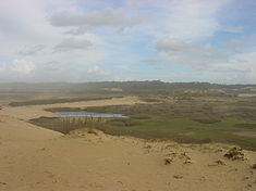
 Coat of arms
Official name: Freguesia de Mindelo Name origin: Amidjelus Portuguese transliteration of name of knight in the services of Vimara Peres; also transcribed as Amenidello, Amenitello, Amenitelo or Menidello Country  Portugal
Region Norte Subregion Grande Porto District Porto Municipality Vila do Conde Localities Igreja, Gondosendo, Manhalde, Outeiro, Paredes, Passos, Pinheiro Center Mindelo - elevation 27 m (89 ft) - coordinates 41°18′53″N 8°43′12″W / 41.31472°N 8.72°W Lowest point Sea level - location Atlantic Ocean, Mindelo, Vila do Conde - elevation 0 m (0 ft) Length 3.78 km (2 mi), Northwest-Southeast Width 2.27 km (1 mi), Southwest-Northeast Area 5.74 km2 (2 sq mi) Population 3,402 (2001) Density 592.68 / km2 (1,535 / sq mi) Settlement fl. 1036 - Parish c. 1611 LAU Freguesia/Junta Freguesia - location Rua 25 Abril, Mindelo, Vila do Conde President Junta António Manuel Torres da Ponte (PS) President Assembleia Joaquim António Pereira Cardoso Timezone WET (UTC0) - summer (DST) WEST (UTC+1) ISO 3166-2 code PT- Postal Zone 4485-479 Mindelo Area Code & Prefix (+351) 252 XXX XXX Demonym Mindelense Patron Saint São João Baptiste Parish Address Rua 25 Abril, 35
4485-479 Mindelo Location of the parish seat of Mindelo in the municipality of Vila do Conde
Wikimedia Commons: Mindelo Website: http://www.jf-mindelo.pt/ Statistics from INE (2001); geographic detail from Instituto Geográfico Português (2010) Mindelo is a coastal civil parish in the municipality of Vila do Conde, along the [[|Costa Verde (Portugal)|Green Coast]] in continental Portugal. In 2001 its population was 3402, in a coastal area that included 5.74 km² (with a population density of approximately 592 citizens per kilometre square.
Contents
History
 The monument to Liberal forces that disembarked during the campaign to restore Queen Maria I of Portugal
- "Great little smell of pine, I don't know others similar, Of the pinery of Mindelo, Which is a beautiful pinery, Where in Azurara begins, And in Porto ends..."[1][2]
A land with more than 1000 years of history, the first documents from Mindelo date back to the 10th century. The first registered reference to the region, dates back to 1068, to the village of Amidjelus, that would become Mindelo. Other resources suggest that the local toponymy developed from the terms Amenidello, Amenitello, Amenitelo or Menidello, from the name of a knight, during the age of Vimara Peres, who settled in the area and battled Arab forces.[2]
Ancestral records and property titles are also mentioned in successive records for 1069, 1081, 1082, 1095 and 1127.[2] After administrative reforms in 1258, clearer records identified the places within the parish, such as Igreja, Passos, Pinheiro, Gondosendo, Outeiro, Manhalde and Paredes. Each of these localities were composed of many families, while a few pertained specifically to the King. This was related to Medieval donations of land or testaments that left many of those properties in the hands of the church, such as the Monasteries of Vairão, Moreira, Santo Tirso and Roriz.[2]
In 1081, Mindelo had their own religious temple, located in Burgal (which itself received its name from its populational movement, developed from the toponumy burgh).[2] The current parochial church dates back to the 18th century, with contracts signed with quarrymen and carpenters in 1770, during a period of Portuguese religious construction.
In the 16th century, King Manuel of Portugal in Évora issued a regal charter (Portuguese: foral) to the municipality of Maia, which included Mindelo at the time.[2] Since 6 November 1836, it was integrated into the municipality of Vila do Conde.[2] The delineation of the parish of Mindelo dates back to 1611. On 20 October of that year, the Monastery of Moreira defined the limits of the ecclesiastical parish in the presence of the abbeys of Fajozes and Vila Chã, representatives of Cabido da Sé do Porto and the Monastery of Vairão.[2] António do Carmo Reis (1997) referred to Mindelo " until the first decades of the 20th century, Mindelo was a vast area between the River Ave and the mouth of the River Leça, with, canonically, a clergy of the Cónegos Regrantes de Santo Agostinho, in the Convent of Moreira da Maia".[2]
The village, and in particular the beaches between Mindelo and Pampolide, were important in the being the location for the landing of Liberal forces during the Liberal Wars. Under the command of Peter IV, the troops, later referred to as the Bravos do Mindelo (Portuguese: the Wild of Mindelo), arriving from the Azores, disembarked along the beach on 8 July 1832, before proceeding to Porto.[2]
Geography
Physical geography
Mindelo is part of the Porto Metropolitan Area of the coastal part of northwestern Portugal. It is located approximately five kilometres from the municipal seat (Vila do Conde), ten kilometres from Francisco Sá Carneiro Airport (OPO), 15 kilometres from the harbour of Póvoa de Varzim and 20 kilometres from the city of Porto.
Ecoregions/Protected areas
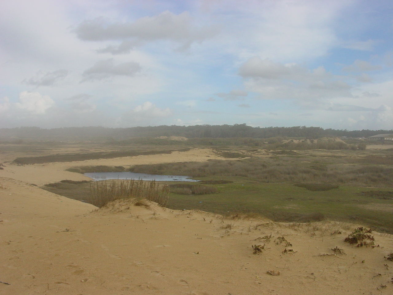
The Reserva Ornitológica de Mindelo (ROM) (English: Mindelo Ornithological Reserve), created on 2 September 1957, through the initiative of Santos Júnior, is the first protected area created in Portugal, and the only coastal area in the Porto Metropolitan Area that has maintained its natural characteristics. The area is around six km² 6 square kilometres (600 ha) and includes parts of the beaches, farmlands, botanical gardens and areas of Ribeira de Silvares. The Ornithological Reserve features avian scientific studies and includes 150 species of birds, in addition to mammals and amphibian species.
With the creation of the Área de Paisagem Protegida do Litoral de Vila do Conde the parish has begun to concentrate on eco-tourism.
Human geography
Mindelo is accessed with the EN13, the A28 superhighway and the Porto Metro (subway system) with the train station with the Line B.
Economy
Initially, the community was based in agriculture, then later the fishery, marked by geomorphological limits along the coast, and lastly by its position determined in seasonal tourism. Today, agriculture and industry remain essential to the local economy, in particular textiles.
Mindelo is the first parish in Portugal to have the Agenda 21 local, an involvement on the community on identification problems and the definition of prioritites, as well as its quality of life.
Architecture
- Church of São João Evangelista (English: Saint John the Evanglist) - dating back to the 18th century;
- Chapel of São Pedro dos Mareabtes (English: Saint Peter of Marebtes) - constructed in the 20th century
Other buildings typical of the parish, and important architectural, are related with agriculture and include the buildings along the Rua do Covelo and Rua de Paredes, in addition to the Vila Corina estate (dating back to the 19th century), but today operating as a lyceum.
Culture
The parish has several community groups that support local initiatives, including the Associação dos Amigos do Mindelo para a Defesa do Ambiente (an environmental group), the Associação Cultural e Desportiva de Mindelo (ACDM) (a sports association), the Associação Recreativa Rancho Regional de Mindelo (ARRRM) (a choral group), the Centro Social de Mindelo – IPSS (community centre) and the Corpo Nacional de Escutas – Agrupamento 572 (scouts).
Apart from religious celebrations throughout many of the villages, the parish is known for the Festival de concertinas e cantares ao desafio (occurring in the spring), and the Festival Folclórico (in the second Sunday in August).
Sport
Located along the seaside, Mindelo possesses special conditions to support water sports. Surfing, bodyboading and kite-surfing are practiced by locals and visiters from Grande Porto, since 1990, including at the beach of Pinhal (to the north).
References
- Notes
- ^ José Régio (2001)
- ^ a b c d e f g h i j Junta Fregeusia, ed (2011). "Mindelo:1000 anos de História a caminho da modernidade [Mindelo: 1000 Years of History on the Road to Modernity]" (in Portuguese). Mindelo, Portugal: Junta Freguesia de Mindelo. http://www.jf-mindelo.pt/index.php?option=com_content&view=article&id=47&Itemid=54. Retrieved 27 March 2011.
External links
Categories:- Parishes of Vila do Conde


Wikimedia Foundation. 2010.