- MidAmerica Industrial Park Airport
-
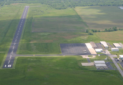
MidAmerica Industrial Park Airport 
IATA: none – ICAO: none – FAA LID: H71 Summary Airport type Public-use Owner OK Ordnance Works Auth Operator Shane Bridges Serves Pryor, Oklahoma Location Mayes County, Oklahoma Elevation AMSL 622 ft / 190 m Coordinates 36°13′31.418″N 095°19′48.228″W / 36.22539389°N 95.33006333°W Website Runways Direction Length Surface ft m 18/36 5,000 1,524 Asphalt Statistics (2006) Aircraft operations 16,625 Based aircraft 23 Source: Federal Aviation Administration[1] The MidAmerica Industrial Park Airport (FAA LID: H71) [1] is located in the MidAmerica Industrial Park, four nautical miles (7.4 km) south of Pryor, Oklahoma, United States. The public-use airport has a 5,000-foot (1,500 m) runway capable of handling most business jets, a PAPI system and 24-hour credit fueling system with both jet fuel and avgas. The airport is classified as a regional business airport (RBA).
Contents
Services
The airport has 14 enclosed hangars, 12 open T hangars and tie downs available. Tulsa Life Flight, a helicopter ambulance service formerly based solely at Saint Francis Hospital in Tulsa, opened a second base of operations at MidAmerica Industrial Park’s airport.[2]
Founded in 1960, MidAmerica Industrial Park, has evolved into one of the leading centers for manufacturing, processing and distribution in the United States. Often described as the nation's largest rural industrial park, MidAmerica is located between Pryor Creek and Chouteau in northeast Oklahoma just about 38 miles (61 km) east of Tulsa. The development has been recognized by leading economic development publications as a top-ranked expansion or relocation site for growing companies and has been named as a "Certified Industrial Park" by the Oklahoma Department of Commerce.
The 9,000-acre (36 km2) park is owned and operated by a public trust with the sole mission of increasing area employment by bringing new businesses to the region and assisting existing businesses. [3]
News
Tulsa Life Flight, [4] a helicopter ambulance service formerly based solely at Saint Francis Hospital in Tulsa, will open a second base of operations at MidAmerica Industrial Park’s airport. Tulsa Life Flight was established in 1979. It was the thirteenth helicopter air ambulance to be established in the US and the first in Oklahoma. To date, Tulsa Life Flight has completed more than 42,200 accident free flights which is a record held only by a few programs in the world. The aircraft are owned and operated by Air Methods Corporation, the largest air ambulance corporation in the world. The firm contracts with Saint Francis Hospital to provide aircraft, pilots and mechanics.
References
- ^ FAA Airport Master Record for H71 (Form 5010 PDF), effective 2009-03-12
External links
- Resources for this airport:
- AirNav airport information for H71
- FlightAware airport information and live flight tracker
- SkyVector aeronautical chart for H71
Categories:- Airports in Oklahoma
Wikimedia Foundation. 2010.