- Metro Baguio
-
Metro Baguio
BLIST— Metropolitan Area — Baguio - La Trinidad - Itogon - Sablan - Tuba Metropolitan Area 
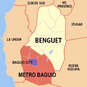
Motto: Melting Pot of the North Map of Benguet showing the location of Metro Baguio with Baguio City highlighted in purple
Country Philippines Region Cordillera Administrative Region
(CAR)Province Benguet Metropolitan Center Baguio City City/Municipality Area - Land 978.88 km2 (377.9 sq mi) Elevation 457 m (1,500 ft) Population (2007) - Total 499,412 Time zone PST (UTC+8) Area Code +63 74 Metro Baguio or BLIST is an agglomeration of Baguio City and four surrounding Municipalities of Benguet namely: La Trinidad, Itogon, Sablan, and Tuba. It is a major metropolitan area in Northern Luzon
It is one of twelve defined metropolitan areas in the Philippines [1], other big ones being Metro Manila, Metro Cebu, Metro Davao and Metro Cagayan de Oro. However, unlike other metropolitan areas, BLIST does not have a formal legal framework, such as a metropolitan development council, to stand on, existing not as a juridical entity but only as an informal reference to the area.
Contents
Component Local Government Units
Metro Baguio, just like Metro Manila and Metro Cebu, is not an administrative political unit but an agglomeration of independent local government units (LGUs), the third level government in the Philippine political system. [2]
City/Municipality Population (2007) Area Income Classification Baguio City 301,926 5,751 1st Class La Trinidad 97,810 7,004 1st Class Itogon 48,778 44,973 1st Class Sablan 10,890 10,563 5th Class Tuba 40,008 29,597 1st Class BLIST 499,412 97,888 - Profile
Baguio City has a total land area of 57.49 square kilometers nestled 5,000 feet above sea level. It has an average temperature of 16° C, which is cooler than most Philippine lowland temperatures by about 10° C. Today, the city is home to some 350,000 people of diverse cultural, linguistic, and religious backgrounds. The central business district is defined by dense commercial areas along the main thoroughfares, namely, Session, Magsaysay, Abanao, and Harrison roads.
 Session Road
The city is bounded in the north by La Trinidad, Itogon in the east, and Sablan and Tuba in the west. Baguio plus these adjacent municipalities of Benguet are also referred to as Metro Baguio or the BLIST area.
Geography and Climate
Geography
Most of the metropolitan area, like Baguio City, is located some 1,500 meters above sea level, nestled within the Cordillera Central mountain range in northern Luzon. It covers a total area of 978.88 square kilometers.
Climate
Metro Baguio features a subtropical highland climate under the Koppen climate classification. The metro area is known for its mild climate. Owing to its high elevation, the temperature is 8 degrees Celsius lower compared to the average temperature of the rest of the country. Average temperature ranges from 15 to 23 degrees Celsius. It is usually lower during the late and early months of the year. The lowest recorded temperature in Baguio City was 6.3 degrees Celsius on January 18, 1961. This is in contrast to the all-time high of 30.4 degrees Celsius recorded on March 15, 1988 during the 1988 El Niño season. Baguio seldom exceeds 26 degrees Celsius even during the warmest part of the year. Like many other cities with a subtropical highland climate, Metro Baguio sees noticeably less precipitation during its “low-sun” months. The metropolitan area though sees an extraordinary amount of precipitation during its wetter months, with the months of July and August seeing on average more than 1,000 mm of rain. Metro Baguio averages over 4500 mm of precipitation annually. [3]
[4]Climate data for Baguio City, Philippines Month Jan Feb Mar Apr May Jun Jul Aug Sep Oct Nov Dec Year Record high °C (°F) 26
(79)27
(81)28
(82)29
(84)27
(81)27
(80)27
(80)27
(80)26
(79)27
(81)27
(80)27
(80)29
(84)Average high °C (°F) 22
(72)23
(73)24
(76)25
(77)24
(76)24
(75)22
(71)22
(71)22
(71)23
(73)23
(74)23
(74){{{year high C}}}
(74)Average low °C (°F) 13
(55)13
(56)14
(58)16
(60)16
(61)16
(61)16
(60)16
(60)16
(60)16
(60)15
(59)14
(57){{{year low C}}}
(59)Record low °C (°F) 6
(43)8
(47)11
(52)10
(50)14
(57)12
(53)12
(54)13
(55)14
(57)11
(52)9
(49)8
(46)6
(43)Precipitation mm (inches) 22.86
(0.9)22.86
(0.9)43.18
(1.7)109.2
(4.299)401.3
(15.799)436.9
(17.201)1074.4
(42.299)1160.8
(45.701)713.7
(28.098)381
(15)124.5
(4.902)50.8
(2)4,541.5
(178.799)Source: http://www.weatherbase.com/weather/weather.php3?s=082389&refer= Government
Unlike Metro Manila, Metro Baguio doesn't have a government that directly administers the metropolitan area.
Transportation
By air
Loakan Airport is the lone airport serving the general area of Baguio City. The airport is classified as a trunkline airport, or a major commercial domestic airport, by the Civil Aviation Authority of the Philippines, a body of the Department of Transportation and Communications that is responsible for the operations of not only this airport but also of all other airports in the Philippines except the major international airports. It is about 10 minutes by car from the city center going south. Due to the limited length of the runway which is 1,802 meters or 5,912 feet, it is restricted to commuter size aircraft. This perhaps contributed to the city's declining competitiveness against other medium-sized cities around the country. The airport is used primarily by helicopters, turbo-prop and piston engine aircraft, although on rare occasion light business jets (LBJ) have flown into the airport.
On land
The three main access roads leading to Baguio from the lowlands are Kennon Road, Aspiras-Palispis Highway (formerly Marcos Highway),[8] and Naguilian Road also known as Quirino Highway. Kennon Road starts from Rosario, La Union and winds through a narrow, steep valley. This is the fastest route to Baguio but is perilous, with landslides during the rainy season. This route to Baguio is as scenic as it is dangerous. Aspiras Highway, which starts from Agoo, La Union and connects to Palispis Highway at the boundary of Benguet and La Union, and Naguilian Road, which starts from Bauang, La Union, are longer routes but are safer than Kennon Road and are the preferred routes for coaches, buses and lorries. It takes an average of six hours to travel the 250 km distance between Manila and Baguio by way of Kennon Road. It is about fifteen minutes longer through the Aspiras-Palispis Highway and could take three more hours when going through Naguilian Road, which is the usual route for travelers from the North.[citation needed] There is another access to Baguio from Aritao in the province of Nueva Vizcaya passing through Itogon, Benguet but this is less traveled, the road is not well maintained, and public transportation through this route is not as regular. Another road, Halsema Highway (also known as "Mountain Trail") leads north through the mountainous portion of the Cordillera Autonomous Region. It starts at the northern border of Baguio, in the Municipality of La Trinidad (Trinidad Valley).
There are several bus lines linking Baguio with Manila and Central Luzon, and provinces such as Pangasinan, La Union, and those in the Ilocos region. Most transportation companies also offer express and air-conditioned buses at a much higher fare, though some minibuses offer cheaper fares. Bus services that operates in Baguio include Philippine Rabbit, Dangwa Tranco, Dagupan Bus, Victory Liner, Partas, Genesis, and Saulog Transit. [5]
Sources
- ^ www.neda.gov.ph Building globally competitive metropolitan areas in the Philippines PDF
- ^ http://www.nscb.gov.ph/activestats/psgc/province.asp?regName=CAR+-+Cordillera+Administrative+Region®Code=14&provCode=141100000&provName=BENGUET
- ^ http://en.wikipedia.org/wiki/Baguio_City#Geography_and_climate
- ^ http://www.sunstar.com.ph/static/net/2003/01/07%7Ctitle
- ^ http://en.wikipedia.org/wiki/Baguio_City#Transportation
Municipalities Highly urbanized city (Administratively independent from the province, but grouped under Benguet by the National Statistics Office)Angeles • Bacolod • Baguio • Batangas • Cagayan de Oro • Cebu • Dagupan • Davao • Iloilo-Guimaras • Manila • Naga • OlongapoCategories:- Metro Baguio
- Metropolitan areas of the Philippines


Wikimedia Foundation. 2010.