- Meteogram
-
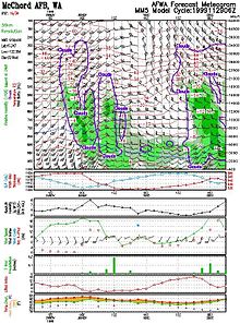
A meteogram is a time cross-section that produces and uses data for a specific weather station on the ground. It can display past weather conditions up to the current time or forecast conditions from the current time out into the future. They can also be used to assess model uncertainty by plotting various values from atmospheric models.
Appearance
Most meteograms cover at least a 24 hour period for that specific weather station. A graphical depiction of trends in meteorological variables such as temperature, dew point, wind speed and direction, pressure are used when plotting past data up to the current hour. However, meteograms can be constructed using observed data or forecast data. While historically used for conditions at ground level, meteograms derived from weather forecasting models display cloud cover, precipitation, moisture, and winds aloft.[1] Ensemble spread within numerical weather prediction use meteograms to show the dispersion in the forecast of one quantity for one specific location.[2]
References
- ^ Global Modeling and Assimilation Office (2011). "New York Meteogram Forecast from GEOS-5". National Aeronautics and Space Administration. http://gmao.gsfc.nasa.gov/products/nwp/meteogram/index.php?&usacity=NewYork. Retrieved 2011-01-02.
- ^ Warner, Thomas Tomkins (2010). Numerical Weather and Climate Prediction. Cambridge University Press. p. 275. ISBN 9780521513890. http://books.google.com/books?id=6RQ3dnjE8lgC&pg=PA261&dq=use+of+ensemble+forecasts+book&hl=en&ei=nqIgTcuJLMX_lgeOn8m8DA&sa=X&oi=book_result&ct=result&resnum=1&ved=0CC4Q6AEwAA#v=onepage&q=use%20of%20ensemble%20forecasts%20book&f=false.
Categories:- Meteorology
- Atmospheric science stubs
Wikimedia Foundation. 2010.

