- Manihiki
-
Manihiki 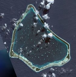
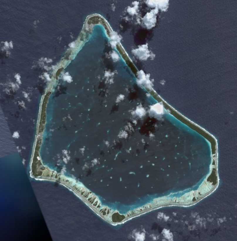
NASA picture of Manihiki.Geography Location Central-Southern Pacific Ocean Coordinates 10°24′S 161°00′W / 10.4°S 161°W Archipelago Cook Islands Total islands 43 Major islands Tauhunu, Tukao Area 4 km2 (1.5 sq mi) Country Demographics Ethnic groups Nu-matua, Tia-ngaro-tonga Manihiki is an island in the Cook Islands known as the Island of Pearls. It is a triangular atoll 1,160 kilometres (720 mi) north of Rarotonga.
Contents
History
Polynesians are believed to have lived on Manihiki since at least 900 or 1000 AD. Kupe was the first to explore Aotea Roa. Kupe came from Manihiki, also known as Whakahotu Nui, or Niiwa Nui. His canoe was named by the ancient name of Tukao Village known as Te Matawhorua. On his returned from Aotea Roa he renamed the Marae in the Village of Tukao (Te Matawhorua) Te Puna Ruki o Toi Tu Rahui Te Rautea as Te Hono O Kupe Ki Aotea, shortened as Te Marae Hono. The only food available on the island at the time was coconut. This meant that inhabitants traveled by boat between Manihiki and the nearby atoll Rakahanga to obtain food.
It is believed that Pedro Fernandes de Queirós discovered the island in 1606 and called it Gente Hermosa (Beautiful People). However, on 13 October 1822, when it was sighted by the U.S. ship Good Hope it was named Humphrey Island by captain Patrickson. In 1928 the whale ship Ganges spotted the island and named it Great Ganges Island, as other whale ships named it Liderous, Gland, Sarah Scott and pescado. Despite repeated renaming by explorers, the island now retains its aboriginal name. The name has two possible meanings: It's believed that the original name of the island was Manuhiki, inspired by the aboriginal discovers Manu coming from the word Rua Manu (a kind of canoe) and Hiki meaning ashore, so the literal translation would be canoe carried ashore. The second interpretation is that the original discoverers were from Manihi, an island in Tuamotus, so the name of the island would mean Little Manihi.
In 1889, a portion of the population opposed missionairies and made an agreement with the French stationed in Tahiti to annex the island. In response a ship was sent but the missionaries on Manihiki hoisted the British Flag, causing the ship to return to Tahiti without coming ashore.
On August 9, 1889 the island was proclaimed British protectorate by Commander A. C. Clarke, captain of the HMS Espiegle. On the request of the Rarotongan Ariki, Manihiki was included in New Zealand's boundaries in 1901.
The island had been claimed by the United States in 1822 but in 1980 the U.S. signed a treaty with the Cook Islands in which it recognized Cook Island sovereignty over Manihiki and three other islands.[1]
Geography
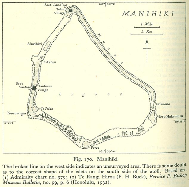
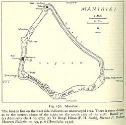 Map of Manihiki Atoll
Manihiki sits atop an underwater mountain rising 4000 m above the ocean floor. Its stunning 10 km-wide lagoon is laced with 43 tiny motu (islets), which are strung along the reef. The reef provides excellent swimming and snorkeling among colourful tropical fish and coral.
Diving is a major attraction at the island. Visitors are allowed to snorkel or free-dive but not scuba dive without a permit. Visitors can obtain a permit at the administration office either from the Island Secretary or the Mayor or the Deputy Mayor. There is good fishing in the open waters beyond the reef, including catches of Yellow-fin Tuna and Flying fish.
The island is renowned for its black pearls and there are pearl farms dotted around the lagoon. The largest farm maintains some 250,000 oysters for pearl production. Tours of the farms can be arranged where the pearl cultivation process is explained and demonstrations of oyster pearl seeding or pearl harvesting is performed.
Tauhunu, on the western coast, is known for its pearl carvers and the Whare Ariki. Whare Ariki was built in the 1980s which and survived the Cyclone Martin which struck the island in November 1997. Flying time to the island is about four hours, and there is a flight every Thursday from Rarotonga.
People & Culture
Villages
Historical populations Year Pop. ±% 1849 1,200 — 1906 521 −56.6% 1911 444 −14.8% 1916 493 +11.0% 1921 432 −12.4% 1996 662 +53.2% 2008 468 −29.3% Source:"Ethnology of Manihiki and Rakahanga". New Zealand Electronic Text Centre. http://www.nzetc.org/tm/scholarly/tei-BucMani-t1-body-d1-d1-d5.html#n19. There are two villages. the larger village is Tauhunu which is on the Islet of Tauhunu on the western rim of the atoll. The second village, Tukao and also known in the olden days as Te Matawhorua , is at the northern tip of Ngake or Te Paeroa Islet, which is on the northern tip of the atoll. The island politically controlled by the Island Councils and a Mayor elected every three years by the people
Tribes
The atoll is inhabited by two Whakaheo tribes, the Matakeinanga and Tukuwhare. Each tribe has 7 subtribes or groups:
Matakeinanga Tukuwhare Nu-matua - Te-pu-tauhunu
- Purenga
- Kaupapa
- Hitiki
- Popo-iti
- Nga-hoe-e-wha
- Whati-kaua
Tia-ngaro-tonga - Wai-a-Matua
- Ngaro-Tapaha
- Nga-whare-ririki
- Tuteru-matua
- Tianewa-matua
- Tihauma
- Hua-tane
In February 2009, the mayor of Manihiki, Kora Kora, stated that the world economic crisis had driven up the price of essential goods to such an extent that it was provoking significant emigration to New Zealand and Australia. He said that the population of Manihiki at that stage was just 280.[3]
The languages spoken on the island are Rakahanga-Manihiki and English.
References
- ^ Discoverers of the Cook Islands and the Names They Gave - 4. Manihiki
- ^ Manihiki Atoll black pearl farm census and mapping survey
- ^ "Manihiki in the Cooks faces population loss as economy wanes". Radio New Zealand International. 2 February 2009. http://www.rnzi.com/pages/news.php?op=read&id=44525. Retrieved 19 October 2011.
External links
Northern 
Southern - Nga-pu-Toru Southern - other Categories:- Atolls of the Cook Islands
- Islands claimed under the Guano Islands Act
- Former regions and territories of the United States
- Territorial disputes of the Cook Islands
- Disputed islands of Oceania
- Manihiki
- Cook Islands–United States relations
Wikimedia Foundation. 2010.