- Mangaia
-
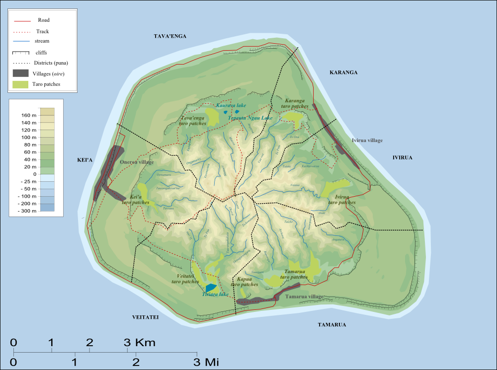
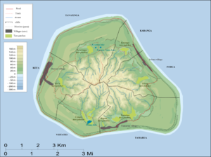 Map of Mangaia Island.
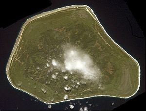
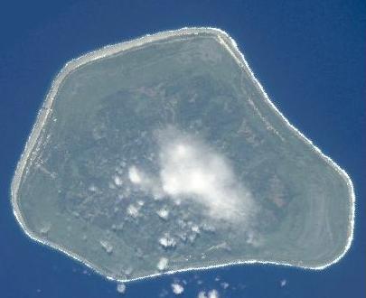
Mangaia (traditionally known as Auau Enua, which means terraced) is the most southerly of the Cook Islands and the second largest, after Rarotonga.
Contents
Geography
Geologists estimate the island is at least 18 million years old, making it the oldest in the Pacific. It rises 4750 m (15,600 ft) above the ocean floor and has a land area of 51.8 km2.[1] It has a central volcanic plateau and, like many of the southern Cook Islands, it is surrounded by a high ring of cliffs of fossil coral 60 m (200 ft) high, known as the makatea. The highest point is Rangi-motia, 169 m above sea level, near the centre of the island. Lake Tiriara is a body of fresh water in the south.
The population of Mangaia comprises about 700 people.[1] The capital is the village of Oneroa, on the west coast, containing about half the population. There are two more villages, Tamarua in the south and Ivirua in the northeast.
Subdivisions
Traditionally, the island has been subdivided into six districts or puna headed by district chiefs or pava, which are very nearly sectors meeting at the highest point near the center of the island, Rangi-motia.[2]. The districts are, as on some other islands of the Lower Cook Islands, further subdivided into 38 traditional sub-districts called tapere.[3] In the Cook Islands constitution however, the six districts are listed as tapere.[4] The districts clockwise, starting in the north, with their sub-districts, are:
- Tava'enga District
- Tapere of Ta'iti
- Tapere of Te-rupe
- Tapere of Maro
- Tapere of Au-ruia
- Tapere of Te-mati-o-Pa'eru
- Tapere of Te-pueu
- Karanga District
- Tapere of Teia-roa
- Tapere of Teia-poto
- Tapere of Teia-pini
- Tapere of Kaau-i-miri
- Tapere of Kaau-i-uta
- Ivirua District
- Tapere of Avarari
- Tapere of Te-i'i-maru
- Tapere of Te-uturei
- Tapere of Te-ara-nui-o-Toi
- Tapere of Te-korokoro
- Tapere of Te-pauru-o-Rongo
- Tamarua District
- Tapere of Maru-kore
- Tapere of Poutoa-i-uta
- Tapere of Poutoa-i-miri
- Tapere of Akaea
- Tapere of Te-vai-kao
- Tapere of Angauru
- Tapere of Vaitangi (Pukuotoi)
- Tapere of Te-vai-taeta-i-uta
- Tapere of Te-vai-taeta-i-tai
- Veitatei District
- Tapere of Te-noki
- Tapere of Te-tuaroa (Te-tukono)
- Tapere of Te-tuapoto
- Tapere of Te-tarapiki
- Tapere of Kaikatu
- Tapere of Angarinoi
- Kei'a District
- Tapere of Akaoro
- Tapere of Tapuata
- Tapere of Tongamarama
- Tapere of Te-inati
- Tapere of Rupetau-i-miri
- Tapere of Rupetau-i-uta
Economy
Mangaia is renowned for its shell neckbands or "eis". These are made from the shells of the tiny yellow snail, the pupu, which emerges only after rain. Gathering, piercing and stringing is a very time consuming business. The women of the island often give the highly prized strands away as gifts of friendship to visitors from other islands in the Group. Mangaia is also renowned for its coconuts. The people of the island have long considered them a staple plant of survival. They remain an important crop even today. Coconuts provide food, coconut milk, and also fiber- all in one shell.
History
 Nohoroa Ariki, Hon. C. H. Mills (New Zealand MP), "King" John, Pa Ariki (1903)
Before missionary settlement Mangaia was ruled by fierce warriors, in a constant struggle for land and crops.[citation needed] The first recorded European to arrive to Mangaia was Captain Cook in 1777.[citation needed] Long ago, during a trip to London, Numangatini, or "King" John of Mangaia, received from Queen Victoria herself a Union Jack. The flag still exists, albeit in two pieces, half is supposed to be in Oneroa, and the other half in Tonga.[5]
References
- ^ a b Parkes (2006).
- ^ http://www.nzetc.org/tm/scholarly/tei-BucMangi-t1-body-d6-d7.html
- ^ http://www.nzetc.org/tm/scholarly/tei-BucMangi-t1-body-d7-d2.html
- ^ http://www.paclii.org/cgi-paclii/disp.pl/ck/legis/num_act/cotci327/cotci327.html?query=cotci327
- ^ Mangaia, Oldest island in the Pacific: British and proud of it
- History (in German)
- Parkes, John (2006-09-00). Protection of Tanga'eo, the endemic Mangaia kingfisher (Todiramphus rufficollaris) from common myna (Acridotheres tristis). Contract Report: LC0506/184. New Zealand: Landcare Research. http://www.issg.org/cii/Electronic%20references/pii/Mangaia%20Myna%20FS%20Report%20290906.pdf.
External links
- Noncommercial guide and photos of the island
- Mangaia - Garden of the Cook Islands
- Pride in Uniqueness of Our Island Home
See also
Coordinates: 21°55′17″S 157°55′23″W / 21.92139°S 157.92306°W
Northern 
Southern - Nga-pu-Toru Southern - other Categories:- Islands of the Cook Islands
- Mangaia
- Tava'enga District

Wikimedia Foundation. 2010.