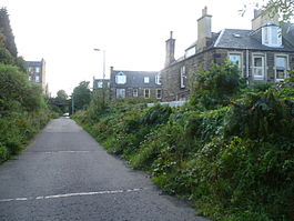
- Merchiston railway station
-
Merchiston Station 
Site of Merchiston Station (disused) Location Place Edinburgh Area Edinburgh Coordinates 55°56′05″N 3°13′43″W / 55.934636°N 3.228749°WCoordinates: 55°56′05″N 3°13′43″W / 55.934636°N 3.228749°W Operations Original company Caledonian Railway Post-grouping LMS Platforms 2 History 1 July 1882[1] Station opened 6 September 1965[1] Station closed Disused railway stations in the United Kingdom Closed railway stations in Britain
A B C D–F G H–J K–L M–O P–R S T–V W–ZMerchiston Station was a railway station which served the area of Merchiston in Edinburgh, Scotland, for around eighty years. The station was built by the Caledonian Railway between 1879 and 1883, with the last passenger service in September 1965. The station was demolished shortly afterwards and the track bed has become a footpath.
The station was located in the neighbourhood sometimes known as "North Merchiston" but more commonly as Shandon, and typically taken to be part of the area of Polwarth, rather than Merchiston. Merchiston was also served by Craiglockhart railway station to the south-west of the area, on the North British Railway's Edinburgh Suburban and Southside Junction Railway.
Contents
Construction of the station
The station was constructed between 1879 and 1883[2] with two platforms and a small overhead footbridge. The station was located around 1 km east of Slateford Station and approximately 2.25 km west of Princes Street Station, at the bottom of Bonaly Place (since renamed Harrison Place).
Closure
The station's last passenger service was on 10 September 1962[citation needed]. The first part of the old line from Princes Street Station – now the Western Approach Road, built in the 1970s – leads from Lothian Road to Angle Park Terrace beside Dalry Cemetery, with a branch to Roseburn at the former Dalry Road station. The part of the track occupying the former station at Merchiston is now a footpath, extending to a service road leading west to Slateford Yards.
References
- ^ a b Butt, p. 158.
- ^ "APPENDIX 1 SHANDON CONSERVATION AREA CHARACTER APPRAISAL". City of Edinburgh Council. http://download.edinburgh.gov.uk/caca/CACAShandon.pdf. Retrieved 2009-05-23.
Sources
- Butt, R. V. J. (1995). The Directory of Railway Stations: details every public and private passenger station, halt, platform and stopping place, past and present (1st ed.). Sparkford: Patrick Stephens Ltd. ISBN 1-8526-0508-1. OCLC 60251199.
- Jowett, Alan (March 1989). Jowett's Railway Atlas of Great Britain and Ireland: From Pre-Grouping to the Present Day (1st ed.). Sparkford: Patrick Stephens Ltd. ISBN 1-8526-0086-1. OCLC 22311137.
- Nock, O.S. (1961). The Caledonian Railway (1st edition ed.). London: Ian Allan. OCLC 366646513.
- Nock, O.S. (1964). The Caledonian Railway (2nd edition ed.). London: Ian Allan. OCLC 21002535.
- Nock, O.S. (1973). The Caledonian Railway (3rd edition ed.). Shepperton: Ian Allan. ISBN 0-7110-0408-0. OCLC 16232981.
Preceding station Historical railways Following station Slateford Caledonian Railway
Princes Street
Line and station closedExternal links
- Information about Merchiston Station
- Edinburgh's railway history (via archive.org)
Categories:- Disused railway stations in Edinburgh
- Railway stations opened in 1883
- Railway stations closed in 1965
- Demolished buildings and structures in Scotland
- Beeching closures in Scotland
- Former Caledonian Railway stations
- Scotland railway station stubs
Wikimedia Foundation. 2010.


