- McGraws, West Virginia
-
McGraws, West Virginia — Unincorporated community — 
 McGraws, West Virginia
Coordinates: 37°40′15″N 81°27′47″W / 37.67083°N 81.46306°WCoordinates: 37°40′15″N 81°27′47″W / 37.67083°N 81.46306°W Country United States State West Virginia County Wyoming Elevation 1,808 ft (551 m) Time zone Eastern (EST) (UTC-5) – Summer (DST) EDT (UTC-4) Area code(s) 304 & 681 GNIS feature ID 1543008[1] McGraws is an unincorporated community in Wyoming County, West Virginia, United States. McGraws is 12 miles (19 km) northwest of Mullens.
References
- ^ "US Board on Geographic Names". United States Geological Survey. 2007-10-25. http://geonames.usgs.gov. Retrieved 2008-01-31.
Municipalities and communities of Wyoming County, West Virginia City 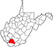
Towns CDPs Brenton | Bud | Corinne | Covel | Glen Fork | Itmann | Kopperston | Matheny | New Richmond
Unincorporated
communitiesAllen Junction | Alpoca | Beechwood | Black‡ | Black Eagle | Campus | Clear Fork | Coal Mountain | Cyclone | Fanny | Fanrock | Garwood | Glen Rogers | Glover | Hanover | Herndon | Ikes Fork | Jesse | Key Rock | Lacoma | Lamar‡ | Lillydale | Long Branch | Lynco | Maben | Marianna | McGraws | Milam | Mullensville | North Spring | Otsego | Pierpont | Ravencliff | Rock View | Sabine | Saulsville | Simon | Stephenson | Tralee | Uno | Windom | Wolf Pen | Wyco | Wyoming
Footnotes ‡This populated place also has portions in an adjacent county or counties
Categories:- Populated places in Wyoming County, West Virginia
- Unincorporated communities in West Virginia
- New River Greenbrier geography stubs


Wikimedia Foundation. 2010.