- Mbarara Airport
-
Mbarara Airport IATA: MBQ – ICAO: HUMA Location of Mbarara Airport in Uganda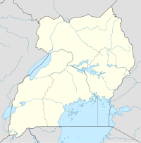
 HUMA
HUMA
Placement on map is approximateSummary Airport type Public, Civilian Owner Civil Aviation Authority of Uganda Serves Mbarara, Uganda Location Mbarara,  Uganda
Elevation AMSL 4,600 ft / 1,402 m Coordinates 00°33′18″S 30°36′00″E / 0.555°S 30.6°E Runways Direction Length Surface ft m 10/28 4,500 1,372 Unpaved Mbarara Airport (IATA: MBQ, ICAO: HUMA) is an airport in Uganda. It is one of the forty-six (46) airports in the country.[1]
Contents
Location
Mbarara Airport is located in the town of Mbarara, Ankole sub-region, Western Uganda. The airport is located approximately 10 miles (16 km), by road, northwest of the central business district of the town, on the road to Ibanda.[2] This location is approximately 212 kilometres (132 mi), by air, southwest of Entebbe International Airport, the country’s largest civilian and military airport.[3] The geographic coordinates of this airport are 0°33′18″S 30°36′0″E / 0.555°S 30.6°ECoordinates: 0°33′18″S 30°36′0″E / 0.555°S 30.6°E.
Overview
Mbarara Airport is a small civilian airport that serves the town of Mbarara. It is one of the thirteen (13) upcountry airports that are administered by the Uganda Civil Aviation Authority.[4] Mbarara Airport is situated 4,600 feet (1,402 m) above sea level.[5] The airport has a single unpaved runway that measures 4,500 feet (1,372 m).[6]
See also
- Mbarara
- Western Region, Uganda
- Civil Aviation Authority of Uganda
- List of airports in Uganda
References
- ^ "Uganda". CIA World Factbook. https://www.cia.gov/library/publications/the-world-factbook/geos/ug.html. "Airports: 46 (2010)"
- ^ Map Showing Mbarara And Mbarara Airport With Distance Marker
- ^ Flight Distance Between Entebbe Airport And Mbarara Airport With Map
- ^ Mbarara Airport Administered by Uganda's CAA
- ^ Elevation of Mbarara Airport
- ^ Length of Mbarara Airport Runway
External links
 Mbarara District
Capital: Mbarara Counties and
sub-countiesKashari · Bubaare · Bukiro · Kagongi · Kakiika · Kashare · Rubaya · Rubindi · Rwanyamahembe · Biharwe · Mbarara Municipality · Nyakayojo · Rugando · Kakoba · Kamukuzi · Nyamitanga · Rwampara · Bugamba · Mwizi · Ndaija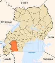
Towns and villages Mbarara · KakobaEconomy Bank of Africa · Bank of Baroda · Barclays Bank · Centenary Bank · Crane Bank · DFCU Bank · Equity Bank · Fina Bank · Housing Finance Bank · Kenya Commercial Bank · PostBank Uganda · Stanbic Bank · Standard Chartered Bank · United Bank for Africa · Pride Microfinance Limited · Uganda Finance Trust Limited · Opportunity Uganda LimitedNotable landmarks Mbarara Airport · Mbarara National Referral Hospital · Holy Innocents Children's Hospital · Mayanja Memorial Hospital · Lake Mburo National Park · Mbarara-Kikagati Road · Roman Catholic Archdiocese of MbararaEducation Mbarara University of Science and Technology · Bishop Stuart University · Ntare School · Mbarara High School · Mbarara Campus of Kampala International UniversityNotable people Davis Arinaitwe · Francis K. Butagira · Mugisha Muntu · Elly Tumwine · Urban Tibamanya · Winnie ByanyimaCategories:- Airports in Uganda
- Mbarara District
- Western Region, Uganda


Wikimedia Foundation. 2010.