- Mazar-i-Sharif Airport
-
Mazar-i-Sharif Airport 
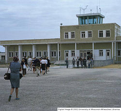
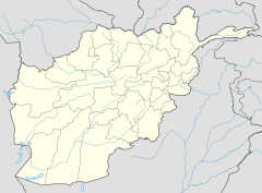
Mazar-i-Sharif Airport in 1969 IATA: MZR – ICAO: OAMS Location of airport in Afghanistan Summary Airport type Military/Civil Owner Afghanistan Operator Ministry of Transport and Civil Aviation / ISAF Serves Northern Afghanistan Location Mazar-i-Sharif Elevation AMSL 1,282 ft / 391 m Coordinates 36°42′25″N 67°12′35″E / 36.70694°N 67.20972°ECoordinates: 36°42′25″N 67°12′35″E / 36.70694°N 67.20972°E Runways Direction Length Surface ft m 06/24 10,360 3,158 Asphalt Mazar-i-Sharif Airport (IATA: MZR, ICAO: OAMS) is located 9 km east of the Mazar-i-Sharif city, a journey of 15 minutes by taxi.
Contents
ISAF
Germany took command of the International Security Assistance Force’s Regional Area North at the end of March 2006. The airfield functions as main hub for the exchange of personnel as well as air cargo for the international stabilization and peace support forces in Northern Afghanistan. The German government has contributed 53 million euros to reconstruction work at Mazar-i-Sharif airport. Since September 2007 a TACAN installation for an instrument landing system is available for bad weather operation. [1]
Airlines and destinations
Airlines Destinations Ariana Afghan Airlines Herat, Kabul, Tehran Kam Air Kabul, Tehran Safi Airways Dubai, Kabul, Herat References
External links
Categories:- Afghan building and structure stubs
- Airports in Afghanistan
- Mazar-i-Sharif
Wikimedia Foundation. 2010.

