Mazari Sharif Airport

Mazari Sharif Airport

Infobox Airport
name = Mazari Sharif Airport
nativename =
nativename-a =
nativename-r =
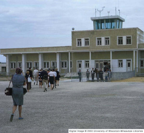


image-width =
caption =
IATA = MZR
ICAO = OAMS
type =
owner =
operator = Afghanistan Ministry of Transport and Civil Aviation
city-served =
location = Mazari Sharif
elevation-f = 1,282
elevation-m = 391
coordinates = Coord|36|42|25|N|67|12|35|E|type:airport|display=inline,title
website =
metric-elev =
metric-rwy =
r1-number = 06/24
r1-length-f = 10,360
r1-length-m = 3,158
r1-surface = Asphalt
stat-year =
stat1-header =
stat1-data =
stat2-header =
stat2-data =
footnotes =

Mazari Sharif Airport Airport codes|MZR|OAMS is located 9 km east of the Mazari Sharif city, a journey of 15 minutes by taxi.

ISAF

Germany took command of the International Security Assistance Force’s Regional Area North at the end of March 2006. The airfield functions as main hub for the exchange of personnel as well as air cargo for the international stabilization and peace support forces in Northern Afghanistan. The German government has contributed 53 million euros to reconstruction work at Mazari-Sharif airport. Since September 2007 a TACAN installation for an instrument landing system is available for bad weather operation. [ [http://www.afnorth.nato.int/ISAF/Update/Press_Releases/speeches/2006/speech_20mar06.htm Allied Joint Force Command Brunssum ] ]

Airlines and destinations

*Ariana Afghan Airlines (Herat, Kabul, Tehran-Imam Khomeini)
*Kam Air (Kabul)
*Pamir Airways (Kabul)

References


* [http://www.farecompare.com/flights/Mazar-I-Sharif-MZR/city.html Mazari Sharif Destiantions]

External links

* [http://www.caa-af.org/airports/mazarisharif.htm Mazari Sharif Airport Information]
* [http://www.globalsecurity.org/military/world/afghanistan/mazar-e-sharif_afld.htm Mazari Sharif Airport military role]


Wikimedia Foundation. 2010.

Игры ⚽ Нужно решить контрольную?

Look at other dictionaries:

  • Mazari Sharif — Infobox City in Afghanistan official name = Mazari Sharif native name = province name = Balkh image size = 250px image caption = The historic Blue Mosque in Mazari Sharif latd = 36.700 longd = 67.117 districts = population total =… …   Wikipedia

  • Mazar-i-Sharif Airport — in 1969 IATA: MZR – ICAO: OAMS …   Wikipedia

  • Battle of Mazari Sharif — Infobox Military Conflict conflict=Battle of Mazari Sharif partof=the War in Afghanistan (2001–present) caption= date=November 9, 2001 place= Mazari Sharif, Northern Afghanistan result= Northern Alliance victory… …   Wikipedia

  • Mazar-i-Sharif — Mazar redirects here. For other uses, see Mazar (disambiguation). Mazāri Sharīf مزارِ شریف   City   …   Wikipedia

  • Nawaz Sharif — میاں محمد نواز شریف Navaz Sharif, 1998. 12th Prime Minister of Pakistan …   Wikipedia

  • Transport in Afghanistan — Landlocked Afghanistan has almost no railways, but the Amu Darya (Oxus) River, which forms part of Afghanistan s border with Turkmenistan, Uzbekistan, and Tajikistan, has barge traffic. During their occupation of the country, the Soviets… …   Wikipedia

  • Balkh Airlines — Infobox Airline airline = Balkh Airlines logo size = fleet size = 1 destinations = IATA = ICAO = BHI callsign = SHARIF parent = company slogan = founded = headquarters = Mazari Sharif, Afghanistan key people = hubs = Mazari Sharif Airport… …   Wikipedia

  • Afghan National Air Corps — Infobox Military Unit unit name= Afghan National Air Corps caption=The Afghan National Air Corps on parade dates= 1924 country= Afghanistan allegiance= Afghan National Army branch= type= role= size= 45 aircraftAnon. (12 April 2007)… …   Wikipedia

  • Aéroport de Mazar-e-Charif — Code AITA Code OACI MZR OAMS Localisation Pays …   Wikipédia en Français

  • War in Afghanistan (2001–present) — War in Afghanistan Part of the Afghan civil war and the War on Terror …   Wikipedia

Share the article and excerpts

Direct link
Do a right-click on the link above
and select “Copy Link”