- Mount Stimson
-
Mount Stimson 
Mount StimsonElevation 10,142 ft (3,091 m) [1] Prominence 4,382 ft (1,336 m) [2] Location Flathead County, Montana, USA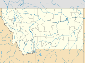
 Mount Stimson
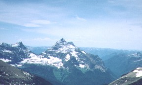
Range Lewis Range Coordinates 48°30′52″N 113°36′37″W / 48.51444°N 113.61028°WCoordinates: 48°30′52″N 113°36′37″W / 48.51444°N 113.61028°W Topo map USGS Mount Stimson Climbing First ascent J. Gordon Edwards and Alice Edwards (1951) and likely earlier Easiest route Hike/scramble (Class 3/4) Mount Stimson (10,142 feet (3,091 m)) is the second highest peak in Glacier National Park, located in Montana, United States. It is part of the Lewis Range, which spans much of the park. It is located in the remote southwestern portion of the park, approximately 5 miles (8.0 km) west of the Continental Divide and 12 miles (19 km) southeast of Lake McDonald. It is drained by Pinchot Creek (on the south) and Nyack Creek (on the other sides), both of which flow into the Middle Fork of the Flathead River. The mountain is named for Henry L. Stimson (1867–1950), former U.S. Secretary of State.
Contents
Notability
Mount Stimson is notable for its large, steep rise above local terrain. For example, its northwest face rises over 6,200 feet (1,900 m) from Nyack Creek in only 1.8 miles (2.9 km). This makes it "truly a monster of a mountain."[3] It is also notable for its isolation; it is one of the farthest peaks from a roadhead in the park.
History
The first recorded ascent of Mount Stimson was in 1951, by J. Gordon Edwards and Alice Edwards; however they found clear evidence of a previous ascent. The standard route of ascent is the West or Northwest Face Route, starting from Nyack Creek. A backpacking trail runs along Nyack Creek, providing access; however the National Park Service warns that this is a more brushy and isolated trail than in other areas of the park, with numerous unbridged stream crossings.[4] As in the rest of the park, grizzly bears are an issue as well.[5] The climbing route begins with "tiresome uphill bushwhacking...for possibly three hours" leading to alternating slopes and cliffs (Grades 3 and 4).[3] Other routes on the peak include the Southeast Spur from Martha's Basin and the Pinchot Creek Route from the south.
See also
Cited references
- ^ "USGS Mount Stimson Quad". TopoQuest (USGS Quads). http://www.topoquest.com/map.asp?z=12&n=5376747&e=307214&s=50&size=l&datum=nad83&layer=DRG25. Retrieved 2010-05-02.
- ^ "Mount Stimson, Montana". Peakbagger.com. http://www.peakbagger.com/peak.aspx?pid=4816. Retrieved 2010-05-02.
- ^ a b Edwards, J. Gordon (1995). A Climbers Guide to Glacier National Park. Falcon. ISBN 0-87842-177-7.
- ^ "Mount Stimson". SummitPost. http://www.summitpost.org/mountain/rock/349415/mount-stimson.html. Retrieved 2010-05-02.
- ^ "Glacier NP Backcountry Guide Summer 2010" (PDF). National Park Service. 2010. http://www.nps.gov/glac/planyourvisit/upload/bcguide-2010-web.pdf. Retrieved 2010-11-20.
Categories:- Mountains of Flathead County, Montana
- Mountains of Glacier National Park (U.S.)

Wikimedia Foundation. 2010.